Difference between revisions of "2021-06-26 51 10"
(GeorgDerReisende is planning an expedition to Clausthal-Zellerfeld) |
m (Location) |
||
| (2 intermediate revisions by one other user not shown) | |||
| Line 18: | Line 18: | ||
== Expedition == | == Expedition == | ||
| − | + | ||
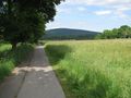
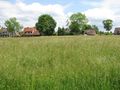
| + | I arrived at 12:36 in Clausthal, which was something later as planned and the bus stop was outside the city which led to a longer walk. Then I walked through the quarters of Clausthal and Zellerfeld and at last I arrived at the hash. It was an open meadow with high grown grass. I danced around a bit, then found the hash and took the usual photos. I waited for other geohashers to meet, but nobody arrived. After hash o'clock I went to the bus stop and traveled home. | ||
== Tracklog == | == Tracklog == | ||
| − | + | ||
| + | {{tracklog|2021-06-26 51 10 GeorgDerReisende.gpx}} | ||
== Photos == | == Photos == | ||
| − | < | + | |
| − | + | <gallery> | |
| − | -- | + | File:2021-06-26 51 10 GeorgDerReisende 09745.jpg | arrived |
| − | + | File:2021-06-26 51 10 GeorgDerReisende 10034.jpg | first glance to the hash area | |
| + | File:2021-06-26 51 10 GeorgDerReisende 10036.jpg | there it is | ||
| + | File:2021-06-26 51 10 GeorgDerReisende 10037.jpg | into this direction | ||
| + | File:2021-06-26 51 10 GeorgDerReisende 10038.jpg | proof 1 | ||
| + | File:2021-06-26 51 10 GeorgDerReisende 10041.jpg | proof 2 | ||
| + | File:2021-06-26 51 10 GeorgDerReisende 10042.jpg | looking north | ||
| + | File:2021-06-26 51 10 GeorgDerReisende 10043.jpg | east | ||
| + | File:2021-06-26 51 10 GeorgDerReisende 10044.jpg | south | ||
| + | File:2021-06-26 51 10 GeorgDerReisende 10045.jpg | west | ||
| + | File:2021-06-26 51 10 GeorgDerReisende 10046.jpg | a lake lay beyond the hash | ||
| + | File:2021-06-26 51 10 GeorgDerReisende 10053.jpg | this is not a raptor attack | ||
| + | File:2021-06-26 51 10 GeorgDerReisende 10059.jpg | the geohasher | ||
</gallery> | </gallery> | ||
| Line 34: | Line 47: | ||
<!-- Add any achievement ribbons you earned below, or remove this section --> | <!-- Add any achievement ribbons you earned below, or remove this section --> | ||
| − | + | {{xkcd centurion|name=[[User:GeorgDerReisende|GeorgDerReisende]]|count=69}} | |
| − | |||
| − | [[ | ||
| − | + | [[Category:Expeditions]] | |
| − | + | [[Category:Expeditions with photos]] | |
| − | |||
| − | |||
| − | |||
| − | |||
| − | |||
| − | |||
| − | |||
| − | |||
| − | |||
| − | |||
| − | |||
| − | |||
| − | |||
| − | |||
[[Category:Coordinates reached]] | [[Category:Coordinates reached]] | ||
| − | + | {{location|DE|NI|GS}} | |
| − | |||
| − | |||
| − | |||
| − | |||
| − | |||
| − | |||
| − | |||
| − | |||
| − | |||
| − | |||
| − | |||
| − | |||
| − | |||
| − | |||
| − | |||
| − | |||
| − | |||
Latest revision as of 13:42, 27 June 2021
| Sat 26 Jun 2021 in 51,10: 51.8223456, 10.3419937 geohashing.info google osm bing/os kml crox |
Location
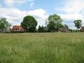
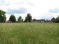
The hash lies on a meadow near Goslarsche Straße in Zellerfeld.
Participants
Plans
It's Saturday. Will be there at hash o'clock.
Expedition
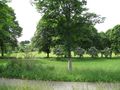
I arrived at 12:36 in Clausthal, which was something later as planned and the bus stop was outside the city which led to a longer walk. Then I walked through the quarters of Clausthal and Zellerfeld and at last I arrived at the hash. It was an open meadow with high grown grass. I danced around a bit, then found the hash and took the usual photos. I waited for other geohashers to meet, but nobody arrived. After hash o'clock I went to the bus stop and traveled home.
Tracklog
Photos
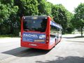
arrived
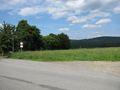
first glance to the hash area
there it is
into this direction
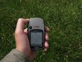
proof 1
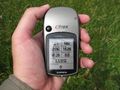
proof 2
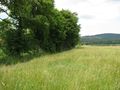
looking north
east
south
west
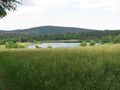
a lake lay beyond the hash
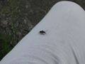
this is not a raptor attack

the geohasher


Achievements
GeorgDerReisende earned the xkcd Sextaginturion achievement
|