Difference between revisions of "2021-07-18 40 -4"
(Created page with "<!-- [[Image:{{{image|IMAGE}}}|thumb|left]] --> <!-- Remove this section if you don't want an image at the top (left) of your report. You should remove the "Image...") |
(→Expedition) |
||
| (2 intermediate revisions by 2 users not shown) | |||
| Line 47: | Line 47: | ||
The part between San Martín de Valdeiglesias and Almorox | The part between San Martín de Valdeiglesias and Almorox | ||
was very nice, sweeping curves through gentle hills. | was very nice, sweeping curves through gentle hills. | ||
| + | I rode this part again eight weeks later in expedition [[2021-09-12_40_-4]]. | ||
Closer to Maqueda, it became a little bit boring, with the | Closer to Maqueda, it became a little bit boring, with the | ||
road being mostly absolutely straight, not to speak about | road being mostly absolutely straight, not to speak about | ||
| Line 82: | Line 83: | ||
<!-- Add any achievement ribbons you earned below, or remove | <!-- Add any achievement ribbons you earned below, or remove | ||
this section --> | this section --> | ||
| − | |||
| − | |||
| − | |||
| − | |||
| − | |||
| − | |||
| − | |||
<!-- An actual expedition: --> | <!-- An actual expedition: --> | ||
| Line 99: | Line 93: | ||
<!-- if you reached your coords: --> | <!-- if you reached your coords: --> | ||
[[Category:Coordinates reached]] | [[Category:Coordinates reached]] | ||
| + | {{location|ES|CM|TO}} | ||
Latest revision as of 17:00, 13 September 2021
| Sun 18 Jul 2021 in 40,-4: 40.0167325, -4.5594099 geohashing.info google osm bing/os kml crox |
Location
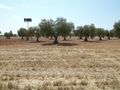
In a stubble field next to the motorway A-5 near Los Cerralbos.
Participants
Plans
Expedition
The geohash was directly next to the motorway A-5. It was in the middle of what looked like an unplanted field in the Maps, but in this season, some precious crops might live there, so I was not sure if I actually could reach it.
It was a good one hour motorcycle ride, so I was inclined to take the comfortable old Goldwing, however, very close to the geohash was a large gas station which provided parking space even for many trucks. I had lamented before about the troubles of getting my big and heavy motorcycle called Wendy parked, but it would never again be as easy as here, so I finally took Wendy for the trip.
The whole ride was over well-developed comfortable roads. The part between San Martín de Valdeiglesias and Almorox was very nice, sweeping curves through gentle hills. I rode this part again eight weeks later in expedition 2021-09-12_40_-4. Closer to Maqueda, it became a little bit boring, with the road being mostly absolutely straight, not to speak about the final part on the four lane motorway A-5.
With Wendy missing any holder for the navigation system, I had once more to remember the route, but I could find the right exit and parked at the gas station as planned. It was only a five minutes walk to the field which hosted the geohash, and it was all stubble, so no problem to enter it.
It was again a hot day (which had hold for all days since a couple of weeks here in central Spain), so I bought a cold soft drink at the gas station, enjoyed it sat down in the shadow, and rode home.
Tracklog
Photos
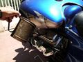
Topping off engin oil…
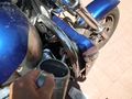
… and coolant. Wendy is in fact the newest of my motorcycles, but still she is 17 years old.
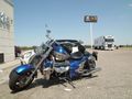
As expected, absolutely no parking problems here at the gas station.
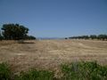
Here it is, in the middle of this stubble field, so no risk of harming crops.
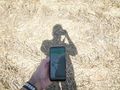
Proof (OK, I know, this way of proof is not new any more). 😜
From the geohash looking west towards the gas station.


