Difference between revisions of "2008-06-05 42 -71"
imported>Ben |
m (fix, sorry) |
||
| (6 intermediate revisions by 5 users not shown) | |||
| Line 1: | Line 1: | ||
| + | {{meetup graticule | ||
| + | | map=<map lat="42" lon="-71" date="2008-06-05" /> | ||
| + | | lat=42 | ||
| + | | lon=-71 | ||
| + | | date=2008-06-05 | ||
| + | | graticule_name=Boston | ||
| + | | graticule_link=Boston, Massachusetts | ||
| + | }} | ||
| + | |||
==The Location== | ==The Location== | ||
| − | + | {{egl|2008-06-05|42|-72|text=Map Coordinates}} | |
The site is located very near to the border between Foxborough, MA and Sharon, MA. It is several hundred meters from nearby Mansfield Street. The site falls on private property; specifically, the yard associated with a large house set back from Mansfield Street. A state park, Borderland State Park, is located close by. | The site is located very near to the border between Foxborough, MA and Sharon, MA. It is several hundred meters from nearby Mansfield Street. The site falls on private property; specifically, the yard associated with a large house set back from Mansfield Street. A state park, Borderland State Park, is located close by. | ||
| Line 7: | Line 16: | ||
==The Geohash== | ==The Geohash== | ||
| − | At roughly 3PM, [[User:Ben|Ben]] and Grace approached the site by car. | + | At roughly 3PM, [[User:Ben|Ben]] and Grace approached the site by car. Disregarding the light mist, we parked nearby and proceeded on foot. |
| − | <gallery caption=" | + | <gallery caption="Sneaking About" widths="200px" heights="200px" perrow="3"> |
Image:2008-06-05-42-71-01.jpg|The driveway from which the hash was accessible. | Image:2008-06-05-42-71-01.jpg|The driveway from which the hash was accessible. | ||
| + | Image:2008-06-05-42-71-02.jpg|The rather impressive house associated with the hash location. We knocked on the door to ask for permission to poke about, but nobody was home. | ||
| + | Image:2008-06-05-42-71-03.jpg|We decided to take a quick look around anyway. Soon enough, we reached the hash. This is the satellite photo of the hash, at the hash; stunning resemblance, no? | ||
| + | Image:2008-06-05-42-71-04.jpg|The large field (lawn?) we crossed to reach the hash. | ||
| + | Image:2008-06-05-42-71-05.jpg|Ben at the hash. | ||
| + | Image:2008-06-05-42-71-06.jpg|Grace at the hash. | ||
| + | Image:2008-06-05-42-71-07.jpg|There was also a pond nearby, presumably constructed by the local denizens. It looked more like a visual accoutrement than a place one would actually swim in. | ||
</gallery> | </gallery> | ||
==Post-Geohash Adventures== | ==Post-Geohash Adventures== | ||
| + | |||
| + | The entrance to Borderland State Park was only a couple of miles away. We paid a $2 entrance fee and looked around for a while. The place was apparently once a wealthy family's living space; their mansion and much of the grounds still stands in its original condition. There is also a sizable pair of ponds, and the usual New England assortment of flora and fauna. The park has a visitor's center with maps and other information; it was reasonably well-equipped, on the whole. They also have an 18-hole frisbee golf course scattered throughout; it looked fairly challenging, if you're into that sort of thing. | ||
| + | |||
| + | <gallery caption="A Walk in the Park" widths="200px" heights="200px" perrow="3"> | ||
| + | Image:2008-06-05-42-71-08.jpg|The mansion, covered in ivy. Note the large, impressive-looking bell in the upper left. | ||
| + | Image:2008-06-05-42-71-09.jpg|The front yard. | ||
| + | Image:2008-06-05-42-71-10.jpg|One of the 18 frisbee golf holes. It took us the better part of an hour to figure out their purpose. | ||
| + | Image:2008-06-05-42-71-11.jpg|Some of the pond. It was a bit over two miles around the whole thing. | ||
| + | </gallery> | ||
| + | |||
| + | [[Category:Expeditions]] | ||
| + | [[Category:Expeditions with photos]] | ||
| + | [[Category:Coordinates reached]] | ||
| + | {{location|US|MA|NO}} | ||
Latest revision as of 18:48, 18 January 2022
| Thu 5 Jun 2008 in Boston: 42.0664391, -71.1843892 geohashing.info google osm bing/os kml crox |
The Location
The site is located very near to the border between Foxborough, MA and Sharon, MA. It is several hundred meters from nearby Mansfield Street. The site falls on private property; specifically, the yard associated with a large house set back from Mansfield Street. A state park, Borderland State Park, is located close by.
The Geohash
At roughly 3PM, Ben and Grace approached the site by car. Disregarding the light mist, we parked nearby and proceeded on foot.
- Sneaking About
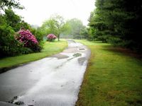
The driveway from which the hash was accessible.
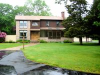
The rather impressive house associated with the hash location. We knocked on the door to ask for permission to poke about, but nobody was home.
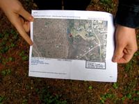
We decided to take a quick look around anyway. Soon enough, we reached the hash. This is the satellite photo of the hash, at the hash; stunning resemblance, no?
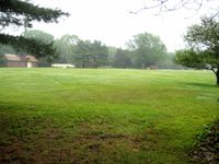
The large field (lawn?) we crossed to reach the hash.
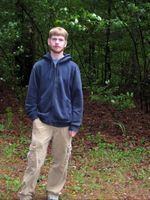
Ben at the hash.
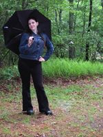
Grace at the hash.
There was also a pond nearby, presumably constructed by the local denizens. It looked more like a visual accoutrement than a place one would actually swim in.


Post-Geohash Adventures
The entrance to Borderland State Park was only a couple of miles away. We paid a $2 entrance fee and looked around for a while. The place was apparently once a wealthy family's living space; their mansion and much of the grounds still stands in its original condition. There is also a sizable pair of ponds, and the usual New England assortment of flora and fauna. The park has a visitor's center with maps and other information; it was reasonably well-equipped, on the whole. They also have an 18-hole frisbee golf course scattered throughout; it looked fairly challenging, if you're into that sort of thing.
- A Walk in the Park

The mansion, covered in ivy. Note the large, impressive-looking bell in the upper left.
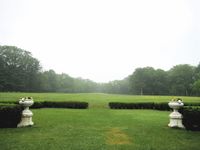
The front yard.
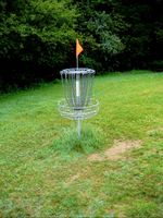
One of the 18 frisbee golf holes. It took us the better part of an hour to figure out their purpose.
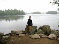
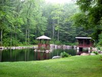
Some of the pond. It was a bit over two miles around the whole thing.


