Difference between revisions of "2008-05-26 37 -77"
From Geohashing
imported>Thomcat (Success/failure category added) |
m |
||
| (One intermediate revision by one other user not shown) | |||
| Line 15: | Line 15: | ||
== Discussion == | == Discussion == | ||
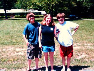
| − | stepol made a run by the location on their way to Short Pump. Pulled into a driveway, found the location in front of someone's house and took pictures of the kids at the site. Homeowner was just pulling out of their driveway when we snapped the picture. | + | [[User:stepol|stepol]] made a run by the location on their way to Short Pump. Pulled into a driveway, found the location in front of someone's house and took pictures of the kids at the site. Homeowner was just pulling out of their driveway when we snapped the picture. |
| Line 27: | Line 27: | ||
[[Category:Expeditions with photos]] | [[Category:Expeditions with photos]] | ||
[[Category:Coordinates reached]] | [[Category:Coordinates reached]] | ||
| + | {{location|US|VA|HC}} | ||
Latest revision as of 12:19, 19 March 2022
| Mon 26 May 2008 in 37,-77: 37.6731281, -77.6073080 geohashing.info google osm bing/os kml crox |
About
These coordinates are located in the Richmond, Virginia graticule on 2008-05-26. Coordinates are 37.673128°, -77.607309°, which is on Shady Grove Road in Glen Allen near Deep Run High School.
Discussion
stepol made a run by the location on their way to Short Pump. Pulled into a driveway, found the location in front of someone's house and took pictures of the kids at the site. Homeowner was just pulling out of their driveway when we snapped the picture.
Pictures
- stepol's kids
