Difference between revisions of "2022-05-23 39 -82"
Michael5000 (talk | contribs) (→Location) |
m (Location) |
||
| (3 intermediate revisions by one other user not shown) | |||
| Line 1: | Line 1: | ||
| − | + | {{meetup graticule | |
| − | |||
| − | |||
| − | |||
| − | |||
| − | |||
| − | |||
| − | |||
| − | |||
| lat={{#explode:{{SUBPAGENAME}}| |1}} | | lat={{#explode:{{SUBPAGENAME}}| |1}} | ||
| lon={{#explode:{{SUBPAGENAME}}| |2}} | | lon={{#explode:{{SUBPAGENAME}}| |2}} | ||
| Line 15: | Line 7: | ||
== Location == | == Location == | ||
| − | In the woods, down | + | In the woods, down back roads off of Ohio State Highway 555. |
== Participants == | == Participants == | ||
| − | |||
| − | |||
| − | + | *[[User:Michael5000|Michael5000]] | |
| − | |||
== Expedition == | == Expedition == | ||
| − | |||
| − | == | + | I woke up in Monroe, Michigan, and when the hashpoints came out saw that there were accessible ones one graticule to the north, two graticules to the west, and two to the south-southeast. I decided to head south-southeast, to this one. |
| − | + | ||
| + | I passed through Toledo, crossed the table-flat agricultural land of northwest Ohio, grazed Columbus, and then entered the maze of rural roads in the southeastern portion of the state. Highway 555 is quite narrow, winding, and little-traveled, so when I turned off onto the gravel sideroad I already felt like I was way out in the backwoods. A few miles down that road, when my GPS started pointing back and to the right, I realized that a very rough branch track I had driven by was the road to the hashpoint. Well! It wasn't gated or signed, but it was not the kind of road you want to drive a rental car down, so I parked. | ||
| + | |||
| + | It was about a mile walk from there to the hashpoint, and it was very, very quiet and peaceful. For all that, I admit that I was worried the whole time that aggressive locals would show up and yell at me for being someplace they didn't want me. That can happen, and it's always a drag. But it didn't happen this time, not even when I passed an otherwise perfectly ordinarily looking house in the middle of the woods, not obviously abandoned but not obviously occupied either. The hashpoint itself was about 10 meters off the road, and it looked like it was going to be a miserable walk out through mud -- but it wasn't! | ||
| + | |||
| + | == The Dead Zone == | ||
| + | |||
| + | I had noticed that there were a number of Virgin graticules still in West Virginia and neighboring states, but until I looked at geohashing.win after this expedition it didn't strike me what a large area in this part of the world had never been geohashed. There are surely several reasons for this -- topographical, demographic, perhaps cultural, and certainly the low "n" of active geohashers -- but this successful expedition (the light blue square here) snuck a little ways into the Appalachian Dead Zone. | ||
| + | |||
| + | [[File:2022-05-23 39 -82 The Dead Zone.JPG|thumb|left]] | ||
| + | |||
| + | I decided to overnight in Athens, Ohio, but got disoriented on those roads -- there's not a lot of signage! -- and ended up in the very charming river town of Marietta instead. My intention was to wake up on 2022-05-24 and geohash the Dead Zone like it had (literally) never been hashed before! But there was nothing available that wouldn't have required a machete, a warrant, or a canoe -- which helps illustrate why it's a Dead Zone, I suppose. So I went to the [https://www.cincinnatiartmuseum.org/ Cincinnati Museum of Art] instead. | ||
== Photos == | == Photos == | ||
| − | + | ||
| − | |||
| − | |||
<gallery perrow="5"> | <gallery perrow="5"> | ||
| + | File:2022-05-23 39 -82 a.jpg|I am not driving a rental car down that side road... | ||
| + | File:2022-05-23 39 -82 b.jpg|...and over that plank bridge. | ||
| + | File:2022-05-23 39 -82 c.jpg|It's pretty, though! | ||
| + | File:2022-05-23 39 -82 d.jpg|After about a mile, the hashpoint is ahead and off to the left. | ||
| + | File:2022-05-23 39 -82 e.jpg|I hike through this scrub to the tree over yonder. | ||
| + | File:2022-05-23 39 -82 f.jpg|Geohasher, triumphant. | ||
| + | File:2022-05-23 39 -82 g.jpg|Ursine mascot, triumphant. | ||
| + | File:2022-05-23 39 -82 i.jpg|Phone, triumphant. | ||
| + | File:2022-05-23 39 -82 h.jpg|Always good to get back to base camp! | ||
</gallery> | </gallery> | ||
== Achievements == | == Achievements == | ||
{{#vardefine:ribbonwidth|800px}} | {{#vardefine:ribbonwidth|800px}} | ||
| − | |||
| − | |||
| − | |||
| − | |||
| − | |||
| − | |||
| − | |||
| − | |||
| − | |||
| − | |||
| − | |||
| − | |||
| − | |||
| − | |||
| − | |||
| − | |||
[[Category:Expeditions]] | [[Category:Expeditions]] | ||
| − | |||
[[Category:Expeditions with photos]] | [[Category:Expeditions with photos]] | ||
| − | |||
| − | |||
| − | |||
| − | |||
| − | |||
[[Category:Coordinates reached]] | [[Category:Coordinates reached]] | ||
| − | + | {{location|US|OH|MA}} | |
| − | |||
| − | |||
| − | |||
| − | |||
| − | |||
| − | |||
| − | |||
| − | |||
| − | |||
| − | |||
| − | |||
| − | |||
| − | |||
| − | |||
| − | |||
| − | |||
| − | |||
Revision as of 02:42, 25 May 2022
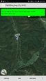
| Mon 23 May 2022 in 39,-82: 39.5929143, -82.0129372 geohashing.info google osm bing/os kml crox |
Location
In the woods, down back roads off of Ohio State Highway 555.
Participants
Expedition
I woke up in Monroe, Michigan, and when the hashpoints came out saw that there were accessible ones one graticule to the north, two graticules to the west, and two to the south-southeast. I decided to head south-southeast, to this one.
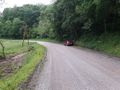
I passed through Toledo, crossed the table-flat agricultural land of northwest Ohio, grazed Columbus, and then entered the maze of rural roads in the southeastern portion of the state. Highway 555 is quite narrow, winding, and little-traveled, so when I turned off onto the gravel sideroad I already felt like I was way out in the backwoods. A few miles down that road, when my GPS started pointing back and to the right, I realized that a very rough branch track I had driven by was the road to the hashpoint. Well! It wasn't gated or signed, but it was not the kind of road you want to drive a rental car down, so I parked.
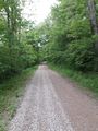
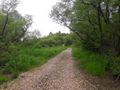
It was about a mile walk from there to the hashpoint, and it was very, very quiet and peaceful. For all that, I admit that I was worried the whole time that aggressive locals would show up and yell at me for being someplace they didn't want me. That can happen, and it's always a drag. But it didn't happen this time, not even when I passed an otherwise perfectly ordinarily looking house in the middle of the woods, not obviously abandoned but not obviously occupied either. The hashpoint itself was about 10 meters off the road, and it looked like it was going to be a miserable walk out through mud -- but it wasn't!
The Dead Zone
I had noticed that there were a number of Virgin graticules still in West Virginia and neighboring states, but until I looked at geohashing.win after this expedition it didn't strike me what a large area in this part of the world had never been geohashed. There are surely several reasons for this -- topographical, demographic, perhaps cultural, and certainly the low "n" of active geohashers -- but this successful expedition (the light blue square here) snuck a little ways into the Appalachian Dead Zone.

I decided to overnight in Athens, Ohio, but got disoriented on those roads -- there's not a lot of signage! -- and ended up in the very charming river town of Marietta instead. My intention was to wake up on 2022-05-24 and geohash the Dead Zone like it had (literally) never been hashed before! But there was nothing available that wouldn't have required a machete, a warrant, or a canoe -- which helps illustrate why it's a Dead Zone, I suppose. So I went to the Cincinnati Museum of Art instead.
Photos
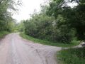
I am not driving a rental car down that side road...
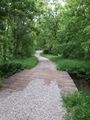
...and over that plank bridge.
It's pretty, though!
After about a mile, the hashpoint is ahead and off to the left.
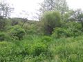
I hike through this scrub to the tree over yonder.

Geohasher, triumphant.
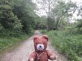
Ursine mascot, triumphant.
Phone, triumphant.
Always good to get back to base camp!


