Difference between revisions of "2022-07-18 58 5"
From Geohashing
m (Location) |
(→Location) |
||
| Line 15: | Line 15: | ||
== Location == | == Location == | ||
<!-- where you've surveyed the hash to be --> | <!-- where you've surveyed the hash to be --> | ||
| − | A headland that juts out into Lutsivatnet. | + | A headland that juts out into Lutsivatnet, Sandnes, Norway. |
== Participants == | == Participants == | ||
Revision as of 18:30, 19 July 2022
| Mon 18 Jul 2022 in 58,5: 58.8752307, 5.8593802 geohashing.info google osm bing/os kml crox |
Location
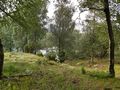
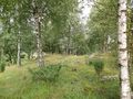
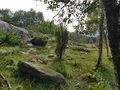
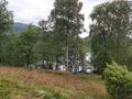
A headland that juts out into Lutsivatnet, Sandnes, Norway.
Participants
Plans
Expedition
The trip to today's hashpoint took place in an area near Lake Lutsivannet in Sandnes municipality, Norway. I had to walk through an area where cows were grazing. It was very wet and dirty so it took longer to get there than I had planned. Still, reaching the hashpoint was no problem.
Tracklog
Photos

Lutsi @58.8752,5.8594
View to Storevågen
View to the northwest
View to the southwest
View to Forenessunda


