Difference between revisions of "2022-08-28 45 -122"
Hamblingreen (talk | contribs) |
Hamblingreen (talk | contribs) m |
||
| (One intermediate revision by one other user not shown) | |||
| Line 1: | Line 1: | ||
| − | [[Image: | + | [[Image:2022-08-28 45 -122 Thwarted.jpg|450px|left|i almost decided to just hop the gate, but my parents talked me out of it.]] |
{{meetup graticule | {{meetup graticule | ||
| Line 13: | Line 13: | ||
== Participants == | == Participants == | ||
| − | Me and, reluctantly, my parents. | + | [[User:Hamblingreen|Hamblingreen]]: Me and, reluctantly, my parents. |
== Plans == | == Plans == | ||
| Line 28: | Line 28: | ||
== Photos == | == Photos == | ||
<gallery perrow="5"> | <gallery perrow="5"> | ||
| − | Image: | + | Image:2022-08-28 45 -122 Biomimicry-trail.jpg|Biomimicry Trail, we got distracted. |
| − | Image: | + | Image:2022-08-28 45 -122 Chill-cow.jpg|A cow we got way too close to! |
| − | Image: | + | Image:2022-08-28 45 -122 Blackberries-galore.jpg|Blackberries found along the trail that slowed down our hike by quite a bit |
| − | Image: | + | Image:2022-08-28 45 -122 Poster.jpg|Left a poster for the property owners to find. If you are reading this, hi! |
| − | Image: | + | Image:2022-08-28 45 -122 Sturgeon-lake.jpg|The lake next to the hashpoint that we hiked around |
| − | Image: | + | Image:2022-08-28 45 -122 Thwarted.jpg|Thwarted! Darn it, it was worth a shot though |
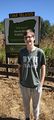
| − | Image: | + | Image:2022-08-28 45 -122 Trail-marker.jpg|A trail marker right next to where we got stuck |
</gallery> | </gallery> | ||
== Achievements == | == Achievements == | ||
{{#vardefine:ribbonwidth|800px}} | {{#vardefine:ribbonwidth|800px}} | ||
| − | {{No trespassing |latitude=45 |longitude=-122 |date=2022-08-28 |image= | + | {{No trespassing |latitude=45 |longitude=-122 |date=2022-08-28 |image=2022-08-28 45 -122 Thwarted.jpg |name= [[User:Hamblingreen|Hamblingreen]] ([[User talk:Hamblingreen|talk]]) |distance= }} |
| − | |||
[[Category:Expeditions]] | [[Category:Expeditions]] | ||
| Line 47: | Line 46: | ||
[[Category:Coordinates not reached]] | [[Category:Coordinates not reached]] | ||
[[Category:Not reached - No public access]] | [[Category:Not reached - No public access]] | ||
| − | + | <!-- "Attended alternate location" means something different and is not really used nowadays --> | |
{{location|US|OR|MU}} | {{location|US|OR|MU}} | ||
Latest revision as of 22:49, 18 September 2022

| Sun 28 Aug 2022 in 45,-122: 45.7196101, -122.8334665 geohashing.info google osm bing/os kml crox |
"No, geohashing has nothing to do with hash."
Contents
Location
A field on Sauvie Island. Unfortunately private property, but it's right next to Oak Island drive. Just west across an irrigation ditch lies a trailhead. Time for a sunday drive!
Participants
Hamblingreen: Me and, reluctantly, my parents.
Plans
Drive across the St. Johns and Sauvie Island bridges to the north end of the island, park by the side of the road and ask whoever lives there to let me into their field. I wouldn't say yes if I were them. Since I don't have a GPS device I'll use OSM for proof. Shoot some pictures on my Pinephone, including one with a Goofy Grin (TM).
Expedition
I expected this to be an easy side-of-the-road hash n' run, but I was sorely mistaken. We left from home at around 3 o'clock, and it took only 10 minutes to get to Sauvie's Island. Driving north from the bridge, I saw Hood, St Helens, and Adams all at once. As we approached the hashpoint, the road forked. I needed to take a left, but there was a locked gate and a "no tresspassing" sign. I don't know how i missed that it was a private road in my research, but in the true spirit of geohashing i decided not to break the law for the internet's sake.
On the way back I posted one of these printed signs made by User:Crox/Poster, writing a note on the poster stating that the hashpoint lies just ahead.
Distractions and Detours
My mom suggested that we head up the right fork a little further. From on top of a dike, we saw what may have been the hashpoint. An abandoned barn and old broken farm equipment dotted a hill just across Gilbert River. As a side note Gilbert river was more like an irrigation ditch, so it wouldn't have been too hard to wade across. After a few more minutes of gravel road driving, we arrived at the Biomimicry nature trail. I showed up in H&M sweatpants and a baggy t-shirt, but hiked 3 miles anyway. At first I was dragging my parents along to my pointless internet adventure, now they were the ones dragging me off to some nature trail. I rolled up my sweatpants and got to hiking. By this point we were thoroughly distracted by the seemingly endless blackberries lining the hike. There were some freely roaming cows chillin a little ways off the trail, so my dad and I walked over to them and said hi. He tried to feed the cow some grass but she wasn't interested. We walked along sturgeon lake a few miles more before turning back and headng home.
Photos
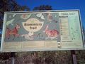
Biomimicry Trail, we got distracted.
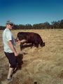
A cow we got way too close to!
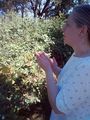
Blackberries found along the trail that slowed down our hike by quite a bit
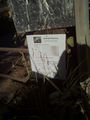
Left a poster for the property owners to find. If you are reading this, hi!
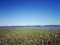
The lake next to the hashpoint that we hiked around
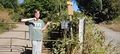
Thwarted! Darn it, it was worth a shot though
A trail marker right next to where we got stuck


Achievements
Hamblingreen (talk) earned the No trespassing consolation prize
|