Difference between revisions of "2022-12-10 58 5"
From Geohashing
(→Expedition) |
(→Achievements) |
||
| (8 intermediate revisions by 2 users not shown) | |||
| Line 54: | Line 54: | ||
{{location|NO|11}} | {{location|NO|11}} | ||
| + | {{Two to the N achievement | ||
| + | | count = 5 | ||
| + | | date = 2022-12-10 | ||
| + | | latitude = 58 | ||
| + | | longitude = 5 | ||
| + | | name = Pica42 | ||
| + | | global = 32 | ||
| + | | reached = true | ||
| + | | retro = true | ||
| + | | graticule = true | ||
| + | }} | ||
| + | {{Last man standing | ||
| + | | latitude = 58 | ||
| + | | longitude = 5 | ||
| + | | date = 2022-12-10 | ||
| + | | gender = man | ||
| + | | name = [[User:Pica42|Pica42]] | ||
| + | }} | ||
| − | + | {{Frozen Geohash | |
| + | | latitude = 58 | ||
| + | | longitude = 5 | ||
| + | | date = 2022-12-10 | ||
| + | | temperature = -3°C | ||
| + | | name = pica42 | ||
| + | }} | ||
| Line 62: | Line 86: | ||
__NOTOC__ | __NOTOC__ | ||
| − | |||
| − | |||
| − | |||
| − | |||
| − | |||
| − | |||
| − | |||
| − | |||
| − | |||
| − | |||
| − | |||
| − | |||
| − | |||
| − | |||
| − | |||
| − | |||
| − | |||
| − | |||
| − | |||
| − | |||
| − | |||
| − | |||
| − | |||
| − | |||
| − | |||
| − | |||
| − | |||
| − | |||
| − | |||
| − | |||
| − | |||
| − | |||
| − | |||
| − | |||
| − | |||
| − | |||
| − | |||
| − | |||
| − | |||
| − | |||
| − | |||
Latest revision as of 15:57, 16 December 2022
| Sat 10 Dec 2022 in 58,5: 58.9946463, 5.6138882 geohashing.info google osm bing/os kml crox |
Location
Randaberg, Norway
Participants
Plans
Expedition
Today it was a bit cold, -3°C but no wind. On my way to the hash, I stopped by a garage to get the brakes on my electric scooter repaired. Afterwards I drove my VW Golf Plus to the center of Randaberg where I parked and walked about 1 km to the hash.
Tracklog
Photos
Randaberg @58.9947,5.6139
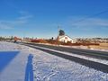
Wiew to the north.
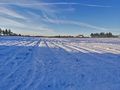
Wiew to the west.
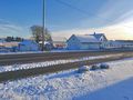
View mother southeast.


Achievements
Pica42 earned the Land geohash achievement
|
Pica42 earned the Two to the N achievement
|
Pica42 earned the Last man standing achievement
|
pica42 earned the Frozen Geohash Achievement
|