Difference between revisions of "2023-02-11 45 -122"
Michael5000 (talk | contribs) (→Participants) |
Michael5000 (talk | contribs) (→Expedition) |
||
| (3 intermediate revisions by 2 users not shown) | |||
| Line 1: | Line 1: | ||
| − | + | {{meetup graticule | |
| − | |||
| − | |||
| − | |||
| − | |||
| − | |||
| − | |||
| − | |||
| − | |||
| lat={{#explode:{{SUBPAGENAME}}| |1}} | | lat={{#explode:{{SUBPAGENAME}}| |1}} | ||
| lon={{#explode:{{SUBPAGENAME}}| |2}} | | lon={{#explode:{{SUBPAGENAME}}| |2}} | ||
| Line 20: | Line 12: | ||
* [[user:michael5000|Michael5000]] | * [[user:michael5000|Michael5000]] | ||
| − | == | + | == Expedition == |
| − | + | ||
| + | This one didn't look very doable the first time I looked at it. When I looked at it a little closer on Friday evening, though, it seemed like a "maybe," and by Saturday morning I was upgrading it to a "probably." In the event, it was perfectly accessible. | ||
| − | + | The only challenge was parking, which was ironic as there were half a dozen sprawling parking lots for various offices and light industrial operations around, all but empty on a Saturday, but they were also gated or carded or being more or less checked out by a guy chilling in a security company car nearby. | |
| − | |||
| − | + | So, I found a gravel patch a few blocks away, and then literally walked right down a concrete path to within 15 feet of the hashpoint, which was at the bottom of a little slope at the edge of a large area that has been cleared for some humongous construction project. I positioned myself atop it, savored the moment, and that was that! | |
| − | |||
== Photos == | == Photos == | ||
| − | + | ||
| − | |||
| − | |||
<gallery perrow="5"> | <gallery perrow="5"> | ||
| + | File:2023-02-11 45 -122 1.jpg|The people of Vancouver kindly laid a trail directly to the hashpoint. | ||
| + | File:2023-02-11 45 -122 2.jpg|It's just beyond the stripe of green grass at the bottom of this photo, at the bottom of a slope. | ||
| + | File:2023-02-11 45 -122 3.jpg|Looking west: "The Quarry Senior Living" | ||
| + | File:2023-02-11 45 -122 4.jpg|This was a hashcot-certified expedition. | ||
| + | File:2023-02-11 45 -122 5.jpg|This was a phone-certified expedition. | ||
</gallery> | </gallery> | ||
| Line 41: | Line 35: | ||
__NOTOC__ | __NOTOC__ | ||
| − | |||
| − | |||
| − | |||
| − | |||
| − | |||
| − | |||
| − | |||
| − | |||
| − | |||
| − | |||
| − | |||
| − | |||
| − | |||
| − | |||
[[Category:Expeditions]] | [[Category:Expeditions]] | ||
| − | |||
[[Category:Expeditions with photos]] | [[Category:Expeditions with photos]] | ||
| − | |||
| − | |||
| − | |||
| − | |||
| − | |||
[[Category:Coordinates reached]] | [[Category:Coordinates reached]] | ||
| − | + | {{location|US|WA|CR}} | |
| − | |||
| − | |||
| − | |||
| − | |||
| − | |||
| − | |||
| − | |||
| − | |||
| − | |||
| − | |||
| − | |||
| − | |||
| − | |||
| − | |||
| − | |||
| − | |||
| − | |||
Latest revision as of 14:37, 10 May 2023
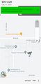
| Sat 11 Feb 2023 in 45,-122: 45.6191979, -122.4883106 geohashing.info google osm bing/os kml crox |
Location
Behind a retirement community in east Vancouver.
Participants
Expedition
This one didn't look very doable the first time I looked at it. When I looked at it a little closer on Friday evening, though, it seemed like a "maybe," and by Saturday morning I was upgrading it to a "probably." In the event, it was perfectly accessible.
The only challenge was parking, which was ironic as there were half a dozen sprawling parking lots for various offices and light industrial operations around, all but empty on a Saturday, but they were also gated or carded or being more or less checked out by a guy chilling in a security company car nearby.
So, I found a gravel patch a few blocks away, and then literally walked right down a concrete path to within 15 feet of the hashpoint, which was at the bottom of a little slope at the edge of a large area that has been cleared for some humongous construction project. I positioned myself atop it, savored the moment, and that was that!
Photos
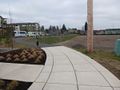
The people of Vancouver kindly laid a trail directly to the hashpoint.
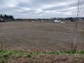
It's just beyond the stripe of green grass at the bottom of this photo, at the bottom of a slope.
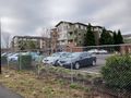
Looking west: "The Quarry Senior Living"
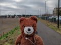
This was a hashcot-certified expedition.
This was a phone-certified expedition.


