Difference between revisions of "2023-06-16 46 -122"
Michael5000 (talk | contribs) (→Location) |
m (Location) |
||
| (7 intermediate revisions by one other user not shown) | |||
| Line 1: | Line 1: | ||
| − | + | {{meetup graticule | |
| − | |||
| − | |||
| − | |||
| − | |||
| − | |||
| − | |||
| − | |||
| − | |||
| lat={{#explode:{{SUBPAGENAME}}| |1}} | | lat={{#explode:{{SUBPAGENAME}}| |1}} | ||
| lon={{#explode:{{SUBPAGENAME}}| |2}} | | lon={{#explode:{{SUBPAGENAME}}| |2}} | ||
| Line 17: | Line 9: | ||
== Participants == | == Participants == | ||
| − | |||
| − | |||
| − | + | *[[user:Michael5000|Michael5000]] | |
| − | |||
== Expedition == | == Expedition == | ||
| − | |||
| − | + | After the total loss of vehicle in [[2023-05-01 45 -119]], I fantasized on the theme of replacing it with a new high-mileage vehicle that could also handle rough roads and easily accommodate a bicycle, and maybe even improve on it with such modern features as turn indicators that still worked. Then, at some point, I realized that by dint of my historical diligence, thrift, hard work, and -- more to the point -- insanely good luck, I could do exactly that. And so it is that last weekend I took possession of a Toyota RAV4 Hybrid "Woodland Edition," a semi-sentient expedition vehicle with the provisional name ''Bright Blue Gravitas''. | |
| − | + | ||
| + | This was its first use in pursuit of a hashpoint. After wrapping up the work-week, I made the familiar slow crossing into Washington state and then continued about 50 miles north to the little berg of Castle Rock which, as I discovered in [[2022-05-14 46 -122]], has a nice little running trail. 4.21 running miles later, I headed east towards the little village of Toutle, last visited on [[2022-06-11 46 -122]]. The rough-road capabilities of the new vehicle weren't really put into play; all I needed to do was pull over on the shoulder of Highway 504 -- the road up to well known local volcano Mt. St. Helens -- and wander a few steps off into the forest. | ||
| + | |||
== Photos == | == Photos == | ||
| − | + | ||
| − | |||
| − | |||
<gallery perrow="5"> | <gallery perrow="5"> | ||
| + | File:2023-06-16 46 -122 1.jpg|The "Spirit Lake Highway" | ||
| + | File:2023-06-16 46 -122 2.jpg|Looking back towards the road, from the hashpoint. | ||
| + | File:2023-06-16 46 -122 3.jpg|Myself, at the hashpoint. | ||
| + | File:2023-06-16 46 -122 4.jpg|''BBG'' enjoying its first expedition. | ||
</gallery> | </gallery> | ||
== Achievements == | == Achievements == | ||
{{#vardefine:ribbonwidth|100%}} | {{#vardefine:ribbonwidth|100%}} | ||
| − | + | ||
| + | *[[Mt. St. Helens, Washington|Mt St Helens]] is now the first graticule outside of my [[Portland, Oregon|home turf]] where I've gone on ten expeditions. | ||
__NOTOC__ | __NOTOC__ | ||
| − | |||
| − | |||
| − | |||
| − | |||
| − | |||
| − | |||
| − | |||
| − | |||
| − | |||
| − | |||
| − | |||
| − | |||
| − | |||
| − | |||
[[Category:Expeditions]] | [[Category:Expeditions]] | ||
| − | |||
[[Category:Expeditions with photos]] | [[Category:Expeditions with photos]] | ||
| − | |||
| − | |||
| − | |||
| − | |||
| − | |||
[[Category:Coordinates reached]] | [[Category:Coordinates reached]] | ||
| − | + | {{location|US|WA|CW}} | |
| − | |||
| − | |||
| − | |||
| − | |||
| − | |||
| − | |||
| − | |||
| − | |||
| − | |||
| − | |||
| − | |||
| − | |||
| − | |||
| − | |||
| − | |||
| − | |||
| − | |||
Revision as of 18:42, 17 June 2023
| Fri 16 Jun 2023 in 46,-122: 46.3403953, -122.7104018 geohashing.info google osm bing/os kml crox |
Location
On the shoulder of state highway 504, just northeast of Toutle.
Participants
Expedition
After the total loss of vehicle in 2023-05-01 45 -119, I fantasized on the theme of replacing it with a new high-mileage vehicle that could also handle rough roads and easily accommodate a bicycle, and maybe even improve on it with such modern features as turn indicators that still worked. Then, at some point, I realized that by dint of my historical diligence, thrift, hard work, and -- more to the point -- insanely good luck, I could do exactly that. And so it is that last weekend I took possession of a Toyota RAV4 Hybrid "Woodland Edition," a semi-sentient expedition vehicle with the provisional name Bright Blue Gravitas.
This was its first use in pursuit of a hashpoint. After wrapping up the work-week, I made the familiar slow crossing into Washington state and then continued about 50 miles north to the little berg of Castle Rock which, as I discovered in 2022-05-14 46 -122, has a nice little running trail. 4.21 running miles later, I headed east towards the little village of Toutle, last visited on 2022-06-11 46 -122. The rough-road capabilities of the new vehicle weren't really put into play; all I needed to do was pull over on the shoulder of Highway 504 -- the road up to well known local volcano Mt. St. Helens -- and wander a few steps off into the forest.
Photos
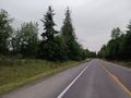
The "Spirit Lake Highway"
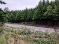
Looking back towards the road, from the hashpoint.

Myself, at the hashpoint.
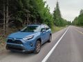
BBG enjoying its first expedition.


Achievements
- Mt St Helens is now the first graticule outside of my home turf where I've gone on ten expeditions.