Difference between revisions of "2023-07-18 45 -122"
From Geohashing
Michael5000 (talk | contribs) (→Achievements) |
Michael5000 (talk | contribs) |
||
| Line 19: | Line 19: | ||
*[[user:Michael5000|Michael5000]] | *[[user:Michael5000|Michael5000]] | ||
| − | |||
| − | |||
| − | |||
== Expedition == | == Expedition == | ||
The workday ended and I was a little at loose ends myself, so I took a look at the hashpoint again and this time I noticed that there was a trail nearby that I'd never run on before. So, I drove down and parked down a gravel road nearby, walked out to the hashpoint, took a few pictures, and then went for a little run down the trail and some of the side roads. | The workday ended and I was a little at loose ends myself, so I took a look at the hashpoint again and this time I noticed that there was a trail nearby that I'd never run on before. So, I drove down and parked down a gravel road nearby, walked out to the hashpoint, took a few pictures, and then went for a little run down the trail and some of the side roads. | ||
| − | |||
| − | |||
| − | |||
== Photos == | == Photos == | ||
Revision as of 03:25, 19 July 2023
| Tue 18 Jul 2023 in 45,-122: 45.3717819, -122.3759162 geohashing.info google osm bing/os kml crox |
Location
On the side of Oregon 224 a few miles north of Estacada.
Participants
Expedition
The workday ended and I was a little at loose ends myself, so I took a look at the hashpoint again and this time I noticed that there was a trail nearby that I'd never run on before. So, I drove down and parked down a gravel road nearby, walked out to the hashpoint, took a few pictures, and then went for a little run down the trail and some of the side roads.
Photos
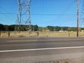
Looking up the powerlines from the hashpoint
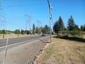
Looking up the highway from the hashpoint
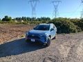
Vehicle stashed nearby
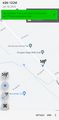
Hashpoint


