Difference between revisions of "2023-07-25 45 -122"
Michael5000 (talk | contribs) (→Participants) |
Michael5000 (talk | contribs) |
||
| Line 20: | Line 20: | ||
*[[user:Michael5000|Michael5000]] | *[[user:Michael5000|Michael5000]] | ||
| − | == | + | == Expedition == |
| − | + | ||
| + | Today's hashpoint was once again surprisingly close to home, so even though it wasn't technically exactly accessible it seemed like it might be worth taking a look. Since it was nice and cool today, I decided to make it a running expedition. | ||
| + | |||
| + | 3.5 miles got me to Going Street -- a name I've always liked -- and within sight of the hashpoint, which was by the fenceline between two residential lots. It didn't seem like anybody was home, and there wasn't a fence or anything, so I put on my "I'm puzzled by something and trying to work it out" face and walked confidently across the lawn to the fence. I looked around. Gosh, something seemed to be puzzling me. But whatever it was, I soon shrugged and discretely returned to the sidewalk, after taking a quick screenshot on my phone. | ||
| − | + | 4 more miles got me near home, but then I added a few loops in order to get a total 8.14 miles, which is the furthest I've run since the Great Ankle Sprain of November 2020. A fine excursion all in all. | |
| − | |||
| − | |||
| − | |||
== Photos == | == Photos == | ||
<gallery perrow="5"> | <gallery perrow="5"> | ||
| − | File:2023-07-25 45 -122 a.jpg | + | File:2023-07-25 45 -122 a.jpg|The fun street art at 21st and Going Street |
| − | File:2023-07-25 45 -122 b.jpg | + | File:2023-07-25 45 -122 b.jpg|That handsome tree is very close to the hashpoint |
| − | File:2023-07-25 45 -122 c.jpg | + | File:2023-07-25 45 -122 c.jpg|I got very close to that handsome tree |
</gallery> | </gallery> | ||
| Line 42: | Line 42: | ||
__NOTOC__ | __NOTOC__ | ||
| − | |||
| − | |||
| − | |||
| − | + | [[Category:Expeditions]] | |
| − | |||
| − | |||
| − | |||
| − | |||
| − | |||
| − | |||
| − | |||
| − | |||
| − | |||
| − | |||
[[Category:Expeditions with photos]] | [[Category:Expeditions with photos]] | ||
| − | |||
| − | |||
| − | |||
| − | |||
| − | |||
[[Category:Coordinates reached]] | [[Category:Coordinates reached]] | ||
| − | |||
| − | |||
| − | |||
| − | |||
| − | |||
| − | |||
| − | |||
| − | |||
| − | |||
| − | |||
| − | |||
| − | |||
| − | |||
| − | |||
| − | |||
| − | |||
| − | |||
| − | |||
Revision as of 03:27, 26 July 2023
| Tue 25 Jul 2023 in 45,-122: 45.5565961, -122.6444469 geohashing.info google osm bing/os kml crox |
Location
In somebody's yard on NE Going Street.
Participants
Expedition
Today's hashpoint was once again surprisingly close to home, so even though it wasn't technically exactly accessible it seemed like it might be worth taking a look. Since it was nice and cool today, I decided to make it a running expedition.
3.5 miles got me to Going Street -- a name I've always liked -- and within sight of the hashpoint, which was by the fenceline between two residential lots. It didn't seem like anybody was home, and there wasn't a fence or anything, so I put on my "I'm puzzled by something and trying to work it out" face and walked confidently across the lawn to the fence. I looked around. Gosh, something seemed to be puzzling me. But whatever it was, I soon shrugged and discretely returned to the sidewalk, after taking a quick screenshot on my phone.
4 more miles got me near home, but then I added a few loops in order to get a total 8.14 miles, which is the furthest I've run since the Great Ankle Sprain of November 2020. A fine excursion all in all.
Photos
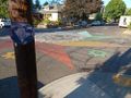
The fun street art at 21st and Going Street
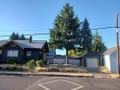
That handsome tree is very close to the hashpoint

I got very close to that handsome tree


