Difference between revisions of "2023-08-19 44 -123"
Michael5000 (talk | contribs) (→Participants) |
m |
||
| (4 intermediate revisions by 2 users not shown) | |||
| Line 13: | Line 13: | ||
}}<!-- edit as necessary --> | }}<!-- edit as necessary --> | ||
== Location == | == Location == | ||
| − | + | In the woods east of Lincoln City. | |
== Participants == | == Participants == | ||
*[[user:Michael5000|Michael5000]] | *[[user:Michael5000|Michael5000]] | ||
| − | == | + | == Expedition == |
| − | + | After [[2023-08-19 45 -123]] I was eager to get lunch, but I'm always terribly susceptible to the usually-false notion that a better eatery than the one I'm passing will surely appear around the next bend, so it wasn't until 90 slow miles south on US 101 that I finally stopped for lunch in Lincoln City, at 430 PM. | |
| + | |||
| + | After refueling, I headed inland on Oregon 18, then turned south on Bear Creek Road for a few miles, then picking up National Forest Road 7, a smoothly paved one-lane ribbon that wound me around another six miles to the Drift Creek Falls Trailhead, where I docked and unloaded the bicycle for the third time today. | ||
| + | |||
| + | I coasted about two kilometers downhill to a stretch of road where a broad curve swept around a hill at an even radius of about 0.18 miles from the hashpoint. The forest was thick, but not bramble-ridden, so it wasn't too hard to get in from the road. From my first point of penetration, I found myself at the bottom of a very steep ferny incline, still a ways from the hashpoint, and it was clear that there was as much vertical distance as horizontal distance involved. That being the case, I trekked back out to the bicycle and backtracked a bit so that I could re-enter the forest at a higher point of elevation. | ||
| + | |||
| + | I've mention in past write-ups that the forests west of the Cascades are not especially easy to move through, but over 15 or 20 minutes I did manage to fight my way up from my new entry point to the top of the very steep ferny incline. That was pretty exciting, especially when my GPS unit got into two digits (in feet) and dropped to 70... 50... 35... and then, there I was at the top of the top incline, still 35 feet away. | ||
| − | + | For the next 30 or 40 minutes, I tried three or four down-the-cliff forays, but could never get closer than 21 feet. The hashpoint itself seemed to have perversely landed in the steepest and most thickly vegetated area of the entire slope. Plus, it was a lousy environment to be navigating by GPS: reception is poor under a thick forest canopy, and when you can only scramble a few steps at a time, the gadget has a hard time showing you whether you are moving towards or away from your target. Well, I've read my ''Hamlet'' and know that discretion is the better part of valor, so eventually I fought my way back out to the road and the bicycle. Dripping with sweat and a few drops of blood from my carved-up legs, I peddled back up the long incline back to the vehicle. | |
| − | |||
| − | + | Onward to [[2023-08-19 44 -122]]. | |
| − | |||
== Photos == | == Photos == | ||
| − | |||
| − | |||
| − | |||
<gallery perrow="5"> | <gallery perrow="5"> | ||
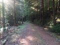
| + | File:2023-08-19 44 -123 a.jpg|It was a day of forest roads | ||
</gallery> | </gallery> | ||
| Line 39: | Line 41: | ||
__NOTOC__ | __NOTOC__ | ||
| − | |||
| − | |||
| − | |||
| − | |||
| − | |||
| − | |||
| − | |||
| − | |||
| − | |||
| − | |||
| − | |||
| − | |||
| − | |||
[[Category:Expeditions]] | [[Category:Expeditions]] | ||
| − | |||
[[Category:Expeditions with photos]] | [[Category:Expeditions with photos]] | ||
| − | |||
| − | |||
| − | |||
| − | |||
| − | |||
| − | |||
| − | |||
| − | |||
| − | |||
[[Category:Coordinates not reached]] | [[Category:Coordinates not reached]] | ||
| − | |||
| − | |||
[[Category:Not reached - Mother Nature]] | [[Category:Not reached - Mother Nature]] | ||
| − | + | {{location|US|OR|LC}} | |
| − | |||
| − | |||
| − | |||
| − | |||
| − | |||
| − | |||
| − | |||
| − | |||
| − | |||
| − | |||
Latest revision as of 15:50, 26 August 2023
| Sat 19 Aug 2023 in 44,-123: 44.9243995, -123.8580770 geohashing.info google osm bing/os kml crox |
Location
In the woods east of Lincoln City.
Participants
Expedition
After 2023-08-19 45 -123 I was eager to get lunch, but I'm always terribly susceptible to the usually-false notion that a better eatery than the one I'm passing will surely appear around the next bend, so it wasn't until 90 slow miles south on US 101 that I finally stopped for lunch in Lincoln City, at 430 PM.
After refueling, I headed inland on Oregon 18, then turned south on Bear Creek Road for a few miles, then picking up National Forest Road 7, a smoothly paved one-lane ribbon that wound me around another six miles to the Drift Creek Falls Trailhead, where I docked and unloaded the bicycle for the third time today.
I coasted about two kilometers downhill to a stretch of road where a broad curve swept around a hill at an even radius of about 0.18 miles from the hashpoint. The forest was thick, but not bramble-ridden, so it wasn't too hard to get in from the road. From my first point of penetration, I found myself at the bottom of a very steep ferny incline, still a ways from the hashpoint, and it was clear that there was as much vertical distance as horizontal distance involved. That being the case, I trekked back out to the bicycle and backtracked a bit so that I could re-enter the forest at a higher point of elevation.
I've mention in past write-ups that the forests west of the Cascades are not especially easy to move through, but over 15 or 20 minutes I did manage to fight my way up from my new entry point to the top of the very steep ferny incline. That was pretty exciting, especially when my GPS unit got into two digits (in feet) and dropped to 70... 50... 35... and then, there I was at the top of the top incline, still 35 feet away.
For the next 30 or 40 minutes, I tried three or four down-the-cliff forays, but could never get closer than 21 feet. The hashpoint itself seemed to have perversely landed in the steepest and most thickly vegetated area of the entire slope. Plus, it was a lousy environment to be navigating by GPS: reception is poor under a thick forest canopy, and when you can only scramble a few steps at a time, the gadget has a hard time showing you whether you are moving towards or away from your target. Well, I've read my Hamlet and know that discretion is the better part of valor, so eventually I fought my way back out to the road and the bicycle. Dripping with sweat and a few drops of blood from my carved-up legs, I peddled back up the long incline back to the vehicle.
Onward to 2023-08-19 44 -122.
Photos
It was a day of forest roads
