Difference between revisions of "2023-08-16 52 -2"
From Geohashing
DocHeather (talk | contribs) (An expedition message sent via Geohash Droid for Android.) |
m (Location) |
||
| (8 intermediate revisions by 2 users not shown) | |||
| Line 14: | Line 14: | ||
== Location == | == Location == | ||
<!-- where you've surveyed the hash to be --> | <!-- where you've surveyed the hash to be --> | ||
| + | Turns out this location was actually in the middle of Breinton Road in Hereford, right near the junction with Breinton Ave. | ||
| + | My phone told me when I was "within GPS precision", which was right in the middle of the road. | ||
== Participants == | == Participants == | ||
<!-- who attended: If you link to your wiki user name in this section, your expedition will be picked up by the various statistics generated for geohashing. You may use three tildes ~ as a shortcut to automatically insert the user signature of the account you are editing with. | <!-- who attended: If you link to your wiki user name in this section, your expedition will be picked up by the various statistics generated for geohashing. You may use three tildes ~ as a shortcut to automatically insert the user signature of the account you are editing with. | ||
--> | --> | ||
| + | I was the only person on my expedition. Going solo. [[User:DocHeather|DocHeather]] ([[User talk:DocHeather|talk]]) | ||
== Plans == | == Plans == | ||
| Line 33: | Line 36: | ||
--> | --> | ||
<gallery perrow="5"> | <gallery perrow="5"> | ||
| + | |||
| + | Image:2023-08-16_52_-2_DocHeather_1692199729841.jpg|After approximately 15 years of knowing about geohashing, I finally made it to a hash on the correct day! [https://openstreetmap.org/?mlat=52.05399167&mlon=-2.73411667&zoom=16 @52.0540,-2.7341] | ||
</gallery> | </gallery> | ||
| Line 38: | Line 43: | ||
{{#vardefine:ribbonwidth|100%}} | {{#vardefine:ribbonwidth|100%}} | ||
<!-- Add any achievement ribbons you earned below, or remove this section --> | <!-- Add any achievement ribbons you earned below, or remove this section --> | ||
| + | |||
| + | {{land geohash | latitude = 52 | longitude = -2 | date = 2023-08-16 | name = DocHeather | image = 2023-08-16 52 -2 DocHeather 1692199729841.jpg }} | ||
| + | {{speed racer | latitude = 52 | longitude = -2 | date = 2023-08-16 | name = DocHeather | image = DocHeatherSpeedRacerProof2023-08-16.jpg | speed = 30mph (maximum legal speed for the residential road)}} | ||
__NOTOC__ | __NOTOC__ | ||
| − | |||
| − | |||
| − | |||
| − | |||
| − | |||
| − | |||
| − | |||
| − | |||
| − | |||
| − | |||
| − | |||
| − | |||
| − | |||
| − | |||
[[Category:Expeditions]] | [[Category:Expeditions]] | ||
| − | |||
[[Category:Expeditions with photos]] | [[Category:Expeditions with photos]] | ||
| − | |||
| − | |||
| − | |||
| − | |||
| − | |||
[[Category:Coordinates reached]] | [[Category:Coordinates reached]] | ||
| − | + | {{location|GB|ENG|HEF}} | |
| − | |||
| − | |||
| − | |||
| − | |||
| − | |||
| − | |||
| − | |||
| − | |||
| − | |||
| − | |||
| − | |||
| − | |||
| − | |||
| − | |||
| − | |||
| − | |||
| − | |||
Latest revision as of 19:42, 31 August 2023
| Wed 16 Aug 2023 in 52,-2: 52.0539522, -2.7341169 geohashing.info google osm bing/os kml crox |
Location
Turns out this location was actually in the middle of Breinton Road in Hereford, right near the junction with Breinton Ave. My phone told me when I was "within GPS precision", which was right in the middle of the road.
Participants
I was the only person on my expedition. Going solo. DocHeather (talk)
Plans
Expedition
Tracklog
Photos
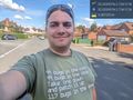
After approximately 15 years of knowing about geohashing, I finally made it to a hash on the correct day! @52.0540,-2.7341

Achievements
DocHeather earned the Land geohash achievement
|

DocHeather earned the Speed racer achievement
by passing through the (52, -2) geohash on 2023-08-16 at 30mph (maximum legal speed for the residential road).