Difference between revisions of "2023-09-25 38 -77"
Michael5000 (talk | contribs) (→Location) |
m (Location) |
||
| (2 intermediate revisions by one other user not shown) | |||
| Line 16: | Line 16: | ||
== Participants == | == Participants == | ||
| − | + | *[[user:Michael5000|Michael5000]] | |
| − | + | *[[user:Mrs.5000|Mrs.5000]] | |
| − | == | + | == Expedition == |
| − | + | After a chill morning with friends near Charlottesville, we started towards the airport to wrap up a week of East Coast travel. Nothing had looked very accessible at first glance, but a double-check of the point nearest the airport revealed that, on some maps, it looked like it was right off a trail in a park. Since we'd given ourselves some extra time, we saw that if there weren't any heinous delays, we would have time to nab it. | |
| + | |||
| + | There weren't any heinous delays, so we drove into Prince William Forest Park and then took a brief hike, a couple of kilometers maybe, on the Farms to Forest Trail. It was a damp walk on a misty day, but not at all muddy -- a fine walk in the woods! And indeed, the hashpoint was only a few steps off the trail. | ||
| − | + | On the way out, we were pulled over by a forest ranger, who felt that I had been exceeding the posted limit of 25 mph. This was certainly true! We got off with a warning, and a Police Geohash accomplishment! That was a first for both of us, as far as we can remember. | |
| − | |||
| − | + | From there, it was back to National Airport and our return flight to the home graticule. | |
| − | |||
== Photos == | == Photos == | ||
| − | + | ||
| − | |||
| − | |||
<gallery perrow="5"> | <gallery perrow="5"> | ||
| + | File:2023-09-25 38 -77 h.jpg|Hasty navigational notes | ||
| + | File:2023-09-25 38 -77 a.jpg|The jump-off point for the hike | ||
| + | File:2023-09-25 38 -77 b.jpg|Safety briefing | ||
| + | File:2023-09-25 38 -77 c.jpg|Hiking trails | ||
| + | File:2023-09-25 38 -77 d.jpg|The 5000s win again! | ||
| + | File:2023-09-25 38 -77 g.jpg|View from the hashpoint | ||
| + | File:2023-09-25 38 -77 e.jpg|Mrs.5000 lingers at the hashpoint | ||
| + | File:2023-09-25 38 -77 f.jpg|The hashcot certifies this expedition | ||
| + | File:2023-09-25 38 -77 i.jpg|The app certifies this expedition | ||
</gallery> | </gallery> | ||
== Achievements == | == Achievements == | ||
{{#vardefine:ribbonwidth|100%}} | {{#vardefine:ribbonwidth|100%}} | ||
| − | |||
| − | + | {{police geohash | |
| − | |||
| − | |||
| − | |||
| − | + | | latitude = 38 | |
| + | | longitude = -77 | ||
| + | | date = 2023-09-25 | ||
| + | | encounter = being warned for speeding | ||
| + | | name = the 5000s | ||
| − | + | }} | |
| − | <!-- | + | <!-- Add any achievement ribbons you earned below, or remove this section --> |
| − | |||
| − | --> | ||
| − | + | __NOTOC__ | |
| − | |||
| − | |||
[[Category:Expeditions]] | [[Category:Expeditions]] | ||
| − | |||
[[Category:Expeditions with photos]] | [[Category:Expeditions with photos]] | ||
| − | |||
| − | |||
| − | |||
| − | |||
| − | |||
[[Category:Coordinates reached]] | [[Category:Coordinates reached]] | ||
| − | + | {{location|US|VA|PW}} | |
| − | |||
| − | |||
| − | |||
| − | |||
| − | |||
| − | |||
| − | |||
| − | |||
| − | |||
| − | |||
| − | |||
| − | |||
| − | |||
| − | |||
| − | |||
| − | |||
| − | |||
Revision as of 00:42, 26 September 2023
| Mon 25 Sep 2023 in 38,-77: 38.6051991, -77.4075229 geohashing.info google osm bing/os kml crox |
Location
Off a trail in Prince William Forest Park.
Participants
Expedition
After a chill morning with friends near Charlottesville, we started towards the airport to wrap up a week of East Coast travel. Nothing had looked very accessible at first glance, but a double-check of the point nearest the airport revealed that, on some maps, it looked like it was right off a trail in a park. Since we'd given ourselves some extra time, we saw that if there weren't any heinous delays, we would have time to nab it.
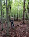
There weren't any heinous delays, so we drove into Prince William Forest Park and then took a brief hike, a couple of kilometers maybe, on the Farms to Forest Trail. It was a damp walk on a misty day, but not at all muddy -- a fine walk in the woods! And indeed, the hashpoint was only a few steps off the trail.
On the way out, we were pulled over by a forest ranger, who felt that I had been exceeding the posted limit of 25 mph. This was certainly true! We got off with a warning, and a Police Geohash accomplishment! That was a first for both of us, as far as we can remember.
From there, it was back to National Airport and our return flight to the home graticule.
Photos

Hasty navigational notes
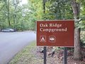
The jump-off point for the hike
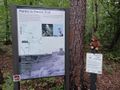
Safety briefing
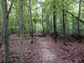
Hiking trails

The 5000s win again!
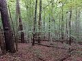
View from the hashpoint
Mrs.5000 lingers at the hashpoint
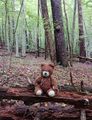
The hashcot certifies this expedition
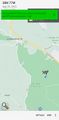
The app certifies this expedition


Achievements
the 5000s earned the Police Geohash Achievement
|