Difference between revisions of "2023-08-12 41 -71"
m (Finally found that page I have been meaning to add) |
|||
| (4 intermediate revisions by 3 users not shown) | |||
| Line 27: | Line 27: | ||
The blue sky above us was turning slightly gray when we left at around 3:40, and I had realized it would have been smarter of me if I had read the forecast and brought a raincoat. It only drizzled, fortunately, and we were able to reach Pomfret School ten minutes before the hour. Another thing that I should have done was a bit more research about the school, as I had no idea that it was a privately owned boarding school, and it is possible we could have been trespassing. No-one was there to witness us, though, and there were no warning signs posted, so in we went. It was a beautiful complex, and I made sure to grab pictures on the way out. | The blue sky above us was turning slightly gray when we left at around 3:40, and I had realized it would have been smarter of me if I had read the forecast and brought a raincoat. It only drizzled, fortunately, and we were able to reach Pomfret School ten minutes before the hour. Another thing that I should have done was a bit more research about the school, as I had no idea that it was a privately owned boarding school, and it is possible we could have been trespassing. No-one was there to witness us, though, and there were no warning signs posted, so in we went. It was a beautiful complex, and I made sure to grab pictures on the way out. | ||
| − | Parking by the hockey rink, we plotted how to move around the lake that blocked our way to the hashpoint. We decided to move counterclockwise through a path of trimmed foliage (Map Man joked that the faculty must have known that geohashers would be there and planned ahead), then cut through the woods. After doing the Geohashing Dance™️ for a few minutes around the hashpoint, we snapped the pictures for the gallery, left my marker, and started back. Heading back, we found a road that had a few bridges that made for an easy return journey, so was it a win or a loss that we took a somewhat difficult approach to get there in the first place? | + | Parking by the hockey rink, we plotted how to move around the lake that blocked our way to the hashpoint. We decided to move counterclockwise through a path of trimmed foliage (Map Man joked that the faculty must have known that geohashers would be there and planned ahead), then cut through the woods. After doing the [[The Dance™|Geohashing Dance™️]] for a few minutes around the hashpoint, we snapped the pictures for the gallery, left my marker, and started back. Heading back, we found a road that had a few bridges that made for an easy return journey, so was it a win or a loss that we took a somewhat difficult approach to get there in the first place? |
Anyhow, Map Man said that he very much enjoyed getting to try something new, and he requested that I invite him on further expeditions when he has time! Our first hash was a great success, and while the rest of my family are still shaking their heads, Map Man and I revel in our triumph and also learn from the handful of missteps we made. A first time for everything, indeed. | Anyhow, Map Man said that he very much enjoyed getting to try something new, and he requested that I invite him on further expeditions when he has time! Our first hash was a great success, and while the rest of my family are still shaking their heads, Map Man and I revel in our triumph and also learn from the handful of missteps we made. A first time for everything, indeed. | ||
| Line 84: | Line 84: | ||
{{land geohash | {{land geohash | ||
| + | | latitude = 41 | ||
| + | | longitude = -71 | ||
| + | | date = 2023-08-12 | ||
| + | | name = [[User:JBest|JBest]] | ||
| + | }} | ||
| + | {{Two to the N achievement | ||
| + | |||
| + | | count = 0 | ||
| + | | date = 2023-08-12 | ||
| latitude = 41 | | latitude = 41 | ||
| longitude = -71 | | longitude = -71 | ||
| − | + | | name = JBest | |
| − | | name = JBest | + | | reached = true (optional - include if you are counting coordinates reached) |
| − | | | ||
}} | }} | ||
| + | |||
__NOTOC__ | __NOTOC__ | ||
| − | |||
| − | |||
| − | |||
| − | |||
| − | |||
| − | |||
| − | |||
| − | |||
| − | |||
| − | |||
| − | |||
| − | |||
| − | |||
| − | |||
[[Category:Expeditions]] | [[Category:Expeditions]] | ||
| − | |||
[[Category:Expeditions with photos]] | [[Category:Expeditions with photos]] | ||
| − | |||
| − | |||
| − | |||
[[Category:Coordinates reached]] | [[Category:Coordinates reached]] | ||
| − | + | {{location|US|CT|WI}} | |
| − | |||
| − | |||
| − | |||
| − | |||
| − | |||
| − | |||
| − | |||
| − | |||
| − | |||
| − | |||
| − | |||
| − | |||
| − | |||
| − | |||
| − | |||
Latest revision as of 18:14, 22 October 2023
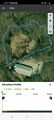
| Sat 12 Aug 2023 in 41,-71: 41.8869944, -71.9711452 geohashing.info google osm bing/os kml crox |
Location
Around 500 feet North of the ice rink of Pomfret School, Pomfret, CT.
Participants
- JBest
- Map Man
Plans
On Friday the 11th, I had discovered that the hash location for this graticule was only a few miles North of Mashamoquet State Forest's Wolf Den campground, which was where my family and friends were happening to be camping for that week! (We play games, hike and discuss Shakespeare.) I decided that I would not want to miss such an easy opportunity for my first hash while I still hadn't obtained my driver's license yet, so I silently plotted a scheme to obtain a ride and people to travel with...
Ultimately, after everyone I persuaded to travel with me called me a nerd (fair, we are all nerds, but this felt EXRTEMELY nerdy even to them), my father agreed to commit the crime with me. Map Man is his blog alias, he used to letterbox with the family when we were younger and I had drawn a comparison between it and geohashing. I didn't count on meeting anybody else for 4:00 on location, but following the tradition for my first go just felt right.
Expedition
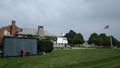
The blue sky above us was turning slightly gray when we left at around 3:40, and I had realized it would have been smarter of me if I had read the forecast and brought a raincoat. It only drizzled, fortunately, and we were able to reach Pomfret School ten minutes before the hour. Another thing that I should have done was a bit more research about the school, as I had no idea that it was a privately owned boarding school, and it is possible we could have been trespassing. No-one was there to witness us, though, and there were no warning signs posted, so in we went. It was a beautiful complex, and I made sure to grab pictures on the way out.
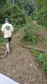
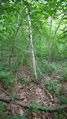
Parking by the hockey rink, we plotted how to move around the lake that blocked our way to the hashpoint. We decided to move counterclockwise through a path of trimmed foliage (Map Man joked that the faculty must have known that geohashers would be there and planned ahead), then cut through the woods. After doing the Geohashing Dance™️ for a few minutes around the hashpoint, we snapped the pictures for the gallery, left my marker, and started back. Heading back, we found a road that had a few bridges that made for an easy return journey, so was it a win or a loss that we took a somewhat difficult approach to get there in the first place?
Anyhow, Map Man said that he very much enjoyed getting to try something new, and he requested that I invite him on further expeditions when he has time! Our first hash was a great success, and while the rest of my family are still shaking their heads, Map Man and I revel in our triumph and also learn from the handful of missteps we made. A first time for everything, indeed.
Tracklog
Our path from the rink, tracked by Map Man's hiking app

Photos
Expedition
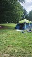
Breaking down our tent before the expedition.

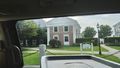
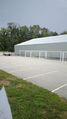
Welcome or no...?
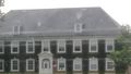
Fancy!
Mind the interior of the vehicle.
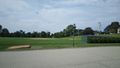
Sportsball field.
Second Sportsball field!
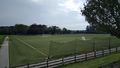
The rink near the hashpoint...
... and the view of where to go.
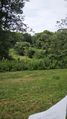
A semi-convenient way to go counterclockwise around the lake.


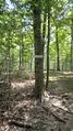
Hashpoint
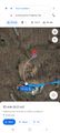
Google Maps screenshot proof of location (constructive advice welcome).

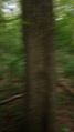
Somewhat blurry photos of the surrounding area...
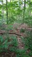
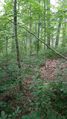

Panorama shot.


...and then there's us!
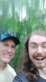
Stupid grins as required!
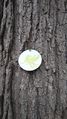
Marker I drew up myself...
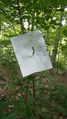
...placed on a nearby branch.


Return Journey
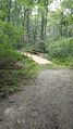
There was a road with a bridge this whole time?!
Cool emblem of the school's sports team.
We unfortunately never crossed paths with JJ... :(

Cross-country whatever, anyone?
Parting shot from the back of the campus
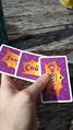
A game of Five Crowns back at the campsite with my non-geohashing friends!


Achievements
JBest earned the Land geohash achievement
|
