Difference between revisions of "2023-10-28 49 11"
([live picture]Seubersdorf train station) |
m (Location) |
||
| (4 intermediate revisions by one other user not shown) | |||
| Line 14: | Line 14: | ||
== Location == | == Location == | ||
<!-- where you've surveyed the hash to be --> | <!-- where you've surveyed the hash to be --> | ||
| + | In a forest near Seubersdorf | ||
== Participants == | == Participants == | ||
<!-- who attended: If you link to your wiki user name in this section, your expedition will be picked up by the various statistics generated for geohashing. You may use three tildes ~ as a shortcut to automatically insert the user signature of the account you are editing with. | <!-- who attended: If you link to your wiki user name in this section, your expedition will be picked up by the various statistics generated for geohashing. You may use three tildes ~ as a shortcut to automatically insert the user signature of the account you are editing with. | ||
--> | --> | ||
| − | + | [[User:Torodeas|Torodeas]] ([[User talk:Torodeas|talk]]) | |
| − | |||
| − | |||
== Expedition == | == Expedition == | ||
<!-- how it all turned out. your narrative goes here. --> | <!-- how it all turned out. your narrative goes here. --> | ||
| + | I've been waiting for this one. I'm close to a [[Subdivision_geohash_achievement | Subdivision]] of the German state of Bavaria into its 7 governmental districts. At this point, I'm lacking two: Upper Palatinate and Lower Bavaria. | ||
| + | |||
| + | Most likely, I'll use the Nuremberg - Vienna train line for both - while there are some other options for Upper Palatinate, Lower Bavaria is almost unreachable for a day trip unless the hash is close to this line of tracks. | ||
| + | |||
| + | Today's hash is close to these tracks and in an accessible forest. | ||
| + | It is in Upper Palatinate, which is the closer one to me, but a deal is a deal. | ||
| + | |||
| + | With the winter quickly approaching, I disregard the official meet-up time of 4 pm, so I can get a bit more of sunlight on my way back (or if anything significantly messes up my scheduled train ride). I plan to arrive at 2 pm instead. | ||
| + | |||
| + | But right at my first change of trains, this plan is getting its first contact with reality. | ||
| + | And as we know, no plan withstands contact with reality. So does mine - the train I want to take to Nuremberg is 25 minutes delays, | ||
| + | much longer than my planned connection in Nuremberg. | ||
| + | |||
| + | Luckily, Fürth-Nuremberg is a very frequent connection with multiple lines - I can hop on one of the various ''Regionalexpress'' - regional express lines -, use one of the two commuter trains (S1 or S6) or I can take the subway. After a quick thought I hurry towards the subway - and see it leave the platform right when I arrive. That was the last option of arriving in Nuremberg in time for my connection. Oh well. | ||
| + | |||
| + | I take the next train bound for Nuremberg, as the next subway is in 7 minutes and trains are considerably faster. This train - a S6 commuter train - is not expected to arrive in time for a connection, and I have to wait 20 minutes for the next train to Neumarkt. | ||
| + | |||
| + | Arriving 20 minutes delayed at Seubersdorf wouldn't bug me. But I still have another train to catch: The last 14 minutes train ride between Neumarkt and Seubersdorf. And that one runs hourly, so my delay will automatically extend to 60 minutes - unless I get to catch my planned train in Neumarkt. I then realize: I've originally planned 21 minutes of connection time in Neumarkt. I'm now in the train 20 minutes later than scheduled. So I have 1 minute to make my connection in Neumarkt. That's tight - but at least it's not impossible. | ||
| + | |||
| + | When we pull into Neumarkt train station, I'm already at the doors, and I see my train bound for Seubersdorf. It's just on the other side of the platform. And I get in. I'm back ''on time'' again. | ||
| + | |||
| + | After arriving at the train station (and remembering to take a photo of the departure board, I've learned since [[2023-09-09_50_11]]), I walk out to the hash. It's in a forested area, approx. 30 minutes by foot from the station. | ||
| + | One main road almost connects the train station and the hash. It even has a footpath. But I still like to avoid roads so I take a slightly more easterly path to the hash. Contrary to OSM in this area, there is a footpath inside the windbreak that continues up to the forest. Technically, that could qualify me for the [[OpenStreetMap achievement]], but I seem to be unable to figure out how to add this. So no price for me and no updates for OSM. | ||
| + | |||
| + | The hash itself is on a relatively steep slope, making the last 100 meters quite challenging. By pure chance, I've arrived at the upper end of the slope, so I can just gradually step down until I reach the hash. After a quick search, I find the spot and record proof. | ||
| + | |||
| + | Remember when I wrote I did learn since [[2023-09-09_50_11]]? I did not. I took a photo of the departure board, and I even looked at it when I started walking back from the hash. But I misread and read / memorized 14:25 (the correct time would have been 14:31). That's quite tight - it took me 40 mins to get to the hash and now I've only got 20. And so I alternate between a fast walk and some running to arrive in time. I do arrive at 14:24 - to see that the train at 14:25 isn't even in the correct direction and I would have had 6 extra minutes. Oh well. | ||
== Tracklog == | == Tracklog == | ||
| Line 33: | Line 59: | ||
--> | --> | ||
<gallery perrow="5"> | <gallery perrow="5"> | ||
| + | |||
| + | Image:2023-10-28_49_11_Torodeas_1698496916838.jpg|Seubersdorf train station | ||
Image:2023-10-28_49_11_Torodeas_1698496814193.jpg|Proof | Image:2023-10-28_49_11_Torodeas_1698496814193.jpg|Proof | ||
| Line 40: | Line 68: | ||
Image:2023-10-28_49_11_Torodeas_1698496847661.jpg|At the hash | Image:2023-10-28_49_11_Torodeas_1698496847661.jpg|At the hash | ||
| − | |||
</gallery> | </gallery> | ||
| Line 46: | Line 73: | ||
{{#vardefine:ribbonwidth|100%}} | {{#vardefine:ribbonwidth|100%}} | ||
<!-- Add any achievement ribbons you earned below, or remove this section --> | <!-- Add any achievement ribbons you earned below, or remove this section --> | ||
| + | {{Public transport geohash | ||
| + | |||
| + | | latitude = 49 | ||
| + | | longitude = 11 | ||
| + | | date = 2023-10-28 | ||
| + | | busline = RB11, S6, S3, RB51 | ||
| + | |||
| + | }} | ||
| + | |||
| + | {{land geohash | ||
| + | |||
| + | | latitude = 49 | ||
| + | | longitude = 11 | ||
| + | | date = 2023-10-28 | ||
| + | }} | ||
__NOTOC__ | __NOTOC__ | ||
<!-- =============== USEFUL CATEGORIES FOLLOW ================ | <!-- =============== USEFUL CATEGORIES FOLLOW ================ | ||
Delete the next line ONLY if you have chosen the appropriate categories below. If you are unsure, don't worry. People will read your report and help you with the classification. --> | Delete the next line ONLY if you have chosen the appropriate categories below. If you are unsure, don't worry. People will read your report and help you with the classification. --> | ||
| − | [[Category: | + | [[Category:Expeditions]] |
| + | [[Category:Expeditions with photos]] | ||
| + | [[Category:Coordinates reached]] | ||
<!-- ==REQUEST FOR TWITTER BOT== Please leave either the New report or the Expedition planning category in as long as you work on it. This helps the twitter bot a lot with announcing the right outcome at the right moment. --> | <!-- ==REQUEST FOR TWITTER BOT== Please leave either the New report or the Expedition planning category in as long as you work on it. This helps the twitter bot a lot with announcing the right outcome at the right moment. --> | ||
| Line 89: | Line 133: | ||
(Don't forget to delete this final close comment marker) --> | (Don't forget to delete this final close comment marker) --> | ||
| + | {{location|DE|BY|NM}} | ||
Latest revision as of 21:42, 28 October 2023
| Sat 28 Oct 2023 in 49,11: 49.1782167, 11.6377728 geohashing.info google osm bing/os kml crox |
Location
In a forest near Seubersdorf
Participants
Expedition
I've been waiting for this one. I'm close to a Subdivision of the German state of Bavaria into its 7 governmental districts. At this point, I'm lacking two: Upper Palatinate and Lower Bavaria.
Most likely, I'll use the Nuremberg - Vienna train line for both - while there are some other options for Upper Palatinate, Lower Bavaria is almost unreachable for a day trip unless the hash is close to this line of tracks.
Today's hash is close to these tracks and in an accessible forest. It is in Upper Palatinate, which is the closer one to me, but a deal is a deal.
With the winter quickly approaching, I disregard the official meet-up time of 4 pm, so I can get a bit more of sunlight on my way back (or if anything significantly messes up my scheduled train ride). I plan to arrive at 2 pm instead.
But right at my first change of trains, this plan is getting its first contact with reality. And as we know, no plan withstands contact with reality. So does mine - the train I want to take to Nuremberg is 25 minutes delays, much longer than my planned connection in Nuremberg.
Luckily, Fürth-Nuremberg is a very frequent connection with multiple lines - I can hop on one of the various Regionalexpress - regional express lines -, use one of the two commuter trains (S1 or S6) or I can take the subway. After a quick thought I hurry towards the subway - and see it leave the platform right when I arrive. That was the last option of arriving in Nuremberg in time for my connection. Oh well.
I take the next train bound for Nuremberg, as the next subway is in 7 minutes and trains are considerably faster. This train - a S6 commuter train - is not expected to arrive in time for a connection, and I have to wait 20 minutes for the next train to Neumarkt.
Arriving 20 minutes delayed at Seubersdorf wouldn't bug me. But I still have another train to catch: The last 14 minutes train ride between Neumarkt and Seubersdorf. And that one runs hourly, so my delay will automatically extend to 60 minutes - unless I get to catch my planned train in Neumarkt. I then realize: I've originally planned 21 minutes of connection time in Neumarkt. I'm now in the train 20 minutes later than scheduled. So I have 1 minute to make my connection in Neumarkt. That's tight - but at least it's not impossible.
When we pull into Neumarkt train station, I'm already at the doors, and I see my train bound for Seubersdorf. It's just on the other side of the platform. And I get in. I'm back on time again.
After arriving at the train station (and remembering to take a photo of the departure board, I've learned since 2023-09-09_50_11), I walk out to the hash. It's in a forested area, approx. 30 minutes by foot from the station. One main road almost connects the train station and the hash. It even has a footpath. But I still like to avoid roads so I take a slightly more easterly path to the hash. Contrary to OSM in this area, there is a footpath inside the windbreak that continues up to the forest. Technically, that could qualify me for the OpenStreetMap achievement, but I seem to be unable to figure out how to add this. So no price for me and no updates for OSM.
The hash itself is on a relatively steep slope, making the last 100 meters quite challenging. By pure chance, I've arrived at the upper end of the slope, so I can just gradually step down until I reach the hash. After a quick search, I find the spot and record proof.
Remember when I wrote I did learn since 2023-09-09_50_11? I did not. I took a photo of the departure board, and I even looked at it when I started walking back from the hash. But I misread and read / memorized 14:25 (the correct time would have been 14:31). That's quite tight - it took me 40 mins to get to the hash and now I've only got 20. And so I alternate between a fast walk and some running to arrive in time. I do arrive at 14:24 - to see that the train at 14:25 isn't even in the correct direction and I would have had 6 extra minutes. Oh well.
Tracklog
Photos
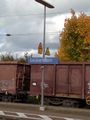
Seubersdorf train station

Proof
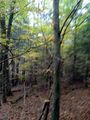
View from the hash
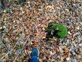
At the hash


Achievements
This user earned the Public transport geohash achievement
|
This user earned the Land geohash achievement
|