Difference between revisions of "2023-11-30 37 -122"
(→Plans) |
m (Location) |
||
| (8 intermediate revisions by 2 users not shown) | |||
| Line 27: | Line 27: | ||
== Expedition == | == Expedition == | ||
<!-- how it all turned out. your narrative goes here. --> | <!-- how it all turned out. your narrative goes here. --> | ||
| + | Getting to Devil's Slide went smoothly, but right after I got off the bus I found that the road I'd been planning on walking up had a sign that said Authorized Personnel Only. Encouraged by the Google reviews, though, I walked down Highway 1 a little bit to the next road which looked like it connected, and this one had no such sign. In fact, there was a "Keep our parks clean" sign, and a gap by the gate clearly for people to walk through. So, I started down the trail. Along the way I encountered some kind of heavily graffiti'd abandoned building, but also some clear signs of trail maintenance and mountain bikers. As I got higher, I could see that the reason for the restricted access sign earlier was a Caltrans maintenance facility that the other road went nearby to. | ||
| + | |||
| + | Eventually, I reached the point on the trail closest to the point, so I left it there. The bushwhacking was considerably better than the last point I reached, since the brush was significantly less dense and closer to the ground. There were still a few difficult places in a drainage, but altogether not too bad. Ultimately I reached the point pretty high on the ridge, near some power lines. After a bit of dancing around to find the exact point, I took some photos. There were really nice views of the ocean and the nearby coastal communities from up there. | ||
| + | |||
| + | I went back down more directly, and not via the shrubby drainage, and encountered some bicyclers on the way down. The bus was about half an hour late, though, so I could have spent more time up in the trails instead of hurrying down as I did. Oh well. | ||
== Photos == | == Photos == | ||
| Line 33: | Line 38: | ||
--> | --> | ||
<gallery perrow="5"> | <gallery perrow="5"> | ||
| + | Image:2023-11-30 37 -122 bus.jpg | Bus stop, looking towards Devil's Slide Tunnels | ||
| + | Image:2023-11-30 37 -122 gate.jpg | The gate to the trails | ||
| + | Image:2023-11-30 37 -122 house.jpg | Abandoned building off the trails | ||
| + | Image:2023-11-30 37 -122 trail thing.jpg | Some fun decoration along the trail | ||
| + | Image:2023-11-30 37 -122 leave.jpg | Can't stay on the trail forever | ||
| + | Image:2023-11-30 37 -122 shrubby.jpg | Pretty brushy up to the point (a bit beyond the power lines) | ||
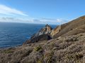
| + | Image:2023-11-30 37 -122 at point.jpg | Looking south along the coast from the point. You can see the Caltrans maintenance facility to the left and the ruins of the triangulation station on the right. | ||
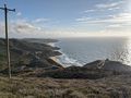
| + | Image:2023-11-30 37 -122 north.jpg | Looking north from a bit lower | ||
| + | Image:2023-11-30 37 -122 proof.png | Proof | ||
</gallery> | </gallery> | ||
| Line 38: | Line 52: | ||
{{#vardefine:ribbonwidth|100%}} | {{#vardefine:ribbonwidth|100%}} | ||
<!-- Add any achievement ribbons you earned below, or remove this section --> | <!-- Add any achievement ribbons you earned below, or remove this section --> | ||
| + | {{Last man standing | latitude = 37 | longitude = -122 | date = 2023-11-30 | name = calymsis}} | ||
| + | {{Public transport geohash | latitude = 37 | longitude = -122 | date = 2023-11-30 | busline = BART and the 110 and 117 buses | name = calymsis}} | ||
| + | {{land geohash | latitude = 37 | longitude = -122 | date = 2023-11-30 | name = calymsis }} | ||
| + | {{Two to the N achievement | count = 2 | latitude = 37 | longitude = -122 | date = 2023-11-30 | name = calymsis}} | ||
__NOTOC__ | __NOTOC__ | ||
| − | |||
| − | |||
| − | |||
| − | |||
| − | |||
| − | |||
| − | |||
| − | |||
| − | |||
| − | |||
| − | |||
| − | |||
| − | |||
| − | |||
[[Category:Expeditions]] | [[Category:Expeditions]] | ||
| − | |||
[[Category:Expeditions with photos]] | [[Category:Expeditions with photos]] | ||
| − | |||
| − | |||
| − | |||
| − | |||
| − | |||
[[Category:Coordinates reached]] | [[Category:Coordinates reached]] | ||
| − | + | {{location|US|CA|SM}} | |
| − | |||
| − | |||
| − | |||
| − | |||
| − | |||
| − | |||
| − | |||
| − | |||
| − | |||
| − | |||
| − | |||
| − | |||
| − | |||
| − | |||
| − | |||
| − | |||
| − | |||
Latest revision as of 16:43, 12 December 2023
| Thu 30 Nov 2023 in 37,-122: 37.5717959, -122.5134015 geohashing.info google osm bing/os kml crox |
Location
Right on Devil's Slide on the Pacific coast.
Participants
Plans
BART to Daly City, 110 bus to Pacifica, 117 bus one stop to Devil's Slide. There's trails marked on Google Maps and OpenStreetMaps here, and there's some Google reviews, so it's likely I'll be able to hike up the hill to the point.
Expedition
Getting to Devil's Slide went smoothly, but right after I got off the bus I found that the road I'd been planning on walking up had a sign that said Authorized Personnel Only. Encouraged by the Google reviews, though, I walked down Highway 1 a little bit to the next road which looked like it connected, and this one had no such sign. In fact, there was a "Keep our parks clean" sign, and a gap by the gate clearly for people to walk through. So, I started down the trail. Along the way I encountered some kind of heavily graffiti'd abandoned building, but also some clear signs of trail maintenance and mountain bikers. As I got higher, I could see that the reason for the restricted access sign earlier was a Caltrans maintenance facility that the other road went nearby to.
Eventually, I reached the point on the trail closest to the point, so I left it there. The bushwhacking was considerably better than the last point I reached, since the brush was significantly less dense and closer to the ground. There were still a few difficult places in a drainage, but altogether not too bad. Ultimately I reached the point pretty high on the ridge, near some power lines. After a bit of dancing around to find the exact point, I took some photos. There were really nice views of the ocean and the nearby coastal communities from up there.
I went back down more directly, and not via the shrubby drainage, and encountered some bicyclers on the way down. The bus was about half an hour late, though, so I could have spent more time up in the trails instead of hurrying down as I did. Oh well.
Photos
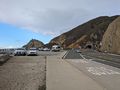
Bus stop, looking towards Devil's Slide Tunnels
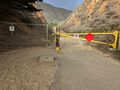
The gate to the trails
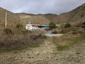
Abandoned building off the trails
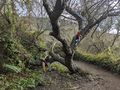
Some fun decoration along the trail
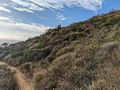
Can't stay on the trail forever
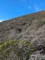
Pretty brushy up to the point (a bit beyond the power lines)
Looking south along the coast from the point. You can see the Caltrans maintenance facility to the left and the ruins of the triangulation station on the right.
Looking north from a bit lower

Proof


Achievements
calymsis earned the Last man standing achievement
|
calymsis earned the Public transport geohash achievement
|
calymsis earned the Land geohash achievement
|
