Difference between revisions of "2016-06-28 50 -126"
imported>Dunstergirl |
m (per Renaming Proposal) |
||
| (16 intermediate revisions by 3 users not shown) | |||
| Line 11: | Line 11: | ||
| lat=50 | | lat=50 | ||
| lon=-126 | | lon=-126 | ||
| − | | date= | + | | date=2016-06-28 |
}} | }} | ||
| Line 30: | Line 30: | ||
So we packed food (supper was already spaghetti, just threw the ingredients in a bag), beverages, GPS, camera, etc. and off we went to the boat. | So we packed food (supper was already spaghetti, just threw the ingredients in a bag), beverages, GPS, camera, etc. and off we went to the boat. | ||
| − | I just showed him roughly where we were going and loaded it up on the GPS and we settled down for a nice ride. Cooked our meal along the way. Marvelling that we live on an island and have a boat and could just do this on the spur of the moment. | + | I just showed him roughly where we were going and loaded it up on the GPS and we settled down for a nice ride. Cooked our meal along the way. Ate it. Marvelling that we live on an island and have a boat and could just do this on the spur of the moment. |
| − | + | Eventually we got as close as we could given the vagaries of tides and GPS but I think we did very well on a first try with the boat. | |
| + | |||
| + | Then we cruised around Stubbs Island to see if any sea lions were in evidence (they weren't) and then headed home again. Maybe saw a whale. When we got back to Rough Bay we checked the crab traps we'd put out the day before but they were empty save for a too-small crab and a wee ?flounder? both of which we threw back. Docked feeling as happy as we'd ever been. Amazing evening on the boat. | ||
| + | |||
| + | All thanks to this bizarre thing called geohashing - we were both grateful and amazed at our excellent adventure. | ||
== Tracklog == | == Tracklog == | ||
| − | + | Remembering how to do this after 4 years. This should work. | |
| − | |||
| − | |||
| − | [ | + | [https://drive.google.com/open?id=1ezMibe7gd7nWaBgC1ENbo1M-BfA&usp=sharing] |
== Photos == | == Photos == | ||
| Line 46: | Line 48: | ||
<gallery perrow="5"> | <gallery perrow="5"> | ||
| − | Image: | + | Image: 2016-06-28 50 -126 A.jpg|Looking NE from the point |
| − | Image: | + | Image: 2016-06-28 50 -126 B.jpg|Pearse Islands from the hashpoint |
| − | Image: | + | Image: 2016-06-28 50 -126 C.jpg|Stubbs Island |
| − | Image: | + | Image: 2016-06-28 50 -126 D.jpg|Donegal Head on Malcolm Island from hashpoint. |
| − | Image: | + | Image: 2016-06-28 50 -126 E.jpg|BC mainland from a little farther along |
| − | Image: | + | Image: 2016-06-28 50 -126 F.jpg|Sointula on the way home. Our house the white with red roof in the middle. |
| − | Image: | + | Image: 2016-06-28 50 -126 G.jpg|Our trusty steed. |
</gallery> | </gallery> | ||
| Line 58: | Line 60: | ||
{{#vardefine:ribbonwidth|800px}} | {{#vardefine:ribbonwidth|800px}} | ||
| − | {{ | + | {{graticule unlocked | latitude = 50 | longitude = -126 | date = 2016-06-28 | name = [[User:dunstergirl|dunstergirl]] | image = 2016-06-28 50 -126 C.jpg }} |
{{#vardefine:ribbonwidth|800px}} | {{#vardefine:ribbonwidth|800px}} | ||
| − | {{ | + | {{water geohash |
| − | | latitude = | + | | latitude = 50 |
| − | | longitude = - | + | | longitude = -126 |
| − | | date = | + | | date = 2016-06-28 |
| name = [[User:dunstergirl|dunstergirl]] | | name = [[User:dunstergirl|dunstergirl]] | ||
}} | }} | ||
| Line 78: | Line 80: | ||
[[Category:Coordinates reached]] | [[Category:Coordinates reached]] | ||
| + | {{location|CA|BC|MW}} | ||
Latest revision as of 05:00, 20 March 2024
| Tue 28 Jun 2016 in 50,-126: 50.6070574, -126.8434197 geohashing.info google osm bing/os kml crox |
Location
On the ocean somewhere south of Donegal Head on Malcolm Island, a bit west of Stubbs Island, somewhere about where Weynton Passage meets Cormorant Channel.
Participants
- dunstergirl. And my partner David on his first geohashing adventure.
Plans
Last minute 4:30 pm "Hey how would you like to go on an adventure in the boat?"
Expedition
I just moved to Malcolm Island last fall but this is my first geohashing adventure since I arrived. I'd told David (who has a boat, which you need around here) much about my previous geohashing adventures in the Robson Valley, and from time to time remembered to check for points, but they were usually far away or inconvenient for the day. But today I checked last minute, there it was maybe an hour's boat trip away, beautiful evening, and he was game.
So we packed food (supper was already spaghetti, just threw the ingredients in a bag), beverages, GPS, camera, etc. and off we went to the boat.
I just showed him roughly where we were going and loaded it up on the GPS and we settled down for a nice ride. Cooked our meal along the way. Ate it. Marvelling that we live on an island and have a boat and could just do this on the spur of the moment.
Eventually we got as close as we could given the vagaries of tides and GPS but I think we did very well on a first try with the boat.
Then we cruised around Stubbs Island to see if any sea lions were in evidence (they weren't) and then headed home again. Maybe saw a whale. When we got back to Rough Bay we checked the crab traps we'd put out the day before but they were empty save for a too-small crab and a wee ?flounder? both of which we threw back. Docked feeling as happy as we'd ever been. Amazing evening on the boat.
All thanks to this bizarre thing called geohashing - we were both grateful and amazed at our excellent adventure.
Tracklog
Remembering how to do this after 4 years. This should work.
Photos
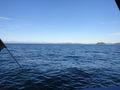
Looking NE from the point
Pearse Islands from the hashpoint
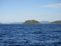
Stubbs Island
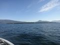
Donegal Head on Malcolm Island from hashpoint.
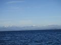
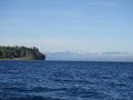
BC mainland from a little farther along
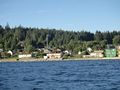
Sointula on the way home. Our house the white with red roof in the middle.
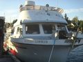
Our trusty steed.


Achievements
dunstergirl earned the Graticule Unlocked Achievement
|
dunstergirl earned the Water geohash achievement
|