Difference between revisions of "2011-09-19 44 -118"
From Geohashing
imported>Michael5000 m (Created page with "{{subst:Expedition |lat = 44 |lon = -118 |date = 2011-09-19 }}") |
m (per Renaming Proposal) |
||
| (17 intermediate revisions by 2 users not shown) | |||
| Line 1: | Line 1: | ||
| − | |||
| − | |||
| − | |||
| − | |||
| − | |||
| − | |||
| − | |||
| − | |||
| − | |||
| − | |||
{{meetup graticule | {{meetup graticule | ||
| lat=44 | | lat=44 | ||
| Line 15: | Line 5: | ||
}} | }} | ||
| − | + | [[File:2011-09-19 44 -118 main.JPG|thumb|left|300 px|The Bear fears no rough road.]] | |
| + | |||
| + | |||
__NOTOC__ | __NOTOC__ | ||
== Location == | == Location == | ||
| − | + | ||
| + | In National Forest land southwest of Unity. | ||
| + | |||
== Participants == | == Participants == | ||
| − | |||
| − | + | *[[User:Michael5000|Michael5000]] | |
| − | + | ||
== Expedition == | == Expedition == | ||
| − | |||
| − | + | This was a fairly straightforward hashpoint if you happened to be passing through the area. A paved road southwest from the little town of Unity ended close to the border of the Wallowa-Whitman National Forest, and following a rough forest service road brought me to within a few hundred meters. A steep climb up a wooded slope was tough going, but led to a smooth stony ridgetop with handsome views of the border of forest and rangeland. | |
| − | + | ||
| + | From here, I returned to Unity and continued to follow U.S. 26 westward towards the next hashpoint. | ||
== Photos == | == Photos == | ||
| − | + | ||
| − | |||
| − | |||
<gallery perrow="5"> | <gallery perrow="5"> | ||
| + | File:2011-09-19 44 -118 1.JPG|The road that leads to | ||
| + | File:2011-09-19 44 -118 2.JPG|the slope that leads to | ||
| + | File:2011-09-19 44 -118 3.JPG|the rocky shelf with | ||
| + | File:2011-09-19 44 -118 4.JPG|the lovely views where | ||
| + | File:2011-09-19 44 -118 5.JPG|the sagebrush hangs out at the hashpoint | ||
| + | File:2011-09-19 44 -118 6.JPG|and so did I. | ||
</gallery> | </gallery> | ||
== Achievements == | == Achievements == | ||
{{#vardefine:ribbonwidth|800px}} | {{#vardefine:ribbonwidth|800px}} | ||
| − | |||
| + | |||
| + | {{Graticule unlocked | ||
| + | | latitude = 44 | ||
| + | | longitude = -118 | ||
| + | | date = 2011-09-19 | ||
| + | | name = [[User:Michael5000|Michael5000]] | ||
| + | | image = 2011-09-19 44 -118 main.JPG | ||
| + | }} | ||
| − | |||
| − | |||
| − | |||
| − | + | {{Multihash2 | count = 4 | date = 2011-09-19 | name = [[User:Michael5000|Michael5000]]}} | |
| − | + | * Six attempts and four successes in one long day. | |
| − | [[ | + | *Eighth Expedition of the [[Endurance Geohashing]] series. |
| − | |||
| − | |||
[[Category:Expeditions]] | [[Category:Expeditions]] | ||
| − | |||
[[Category:Expeditions with photos]] | [[Category:Expeditions with photos]] | ||
| − | |||
| − | |||
| − | |||
| − | |||
| − | |||
[[Category:Coordinates reached]] | [[Category:Coordinates reached]] | ||
| − | + | {{location|US|OR|BA}} | |
| − | |||
| − | |||
| − | |||
| − | |||
| − | |||
| − | |||
| − | |||
| − | |||
| − | |||
Latest revision as of 05:49, 20 March 2024
| Mon 19 Sep 2011 in 44,-118: 44.4223289, -118.2688817 geohashing.info google osm bing/os kml crox |

Location
In National Forest land southwest of Unity.
Participants
Expedition
This was a fairly straightforward hashpoint if you happened to be passing through the area. A paved road southwest from the little town of Unity ended close to the border of the Wallowa-Whitman National Forest, and following a rough forest service road brought me to within a few hundred meters. A steep climb up a wooded slope was tough going, but led to a smooth stony ridgetop with handsome views of the border of forest and rangeland.
From here, I returned to Unity and continued to follow U.S. 26 westward towards the next hashpoint.
Photos
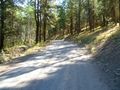
The road that leads to
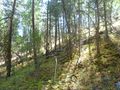
the slope that leads to
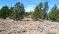
the rocky shelf with
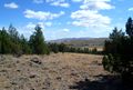
the lovely views where
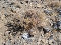
the sagebrush hangs out at the hashpoint
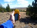
and so did I.


Achievements
Michael5000 earned the Graticule Unlocked Achievement
|
Michael5000 earned the Multihash Achievement
|
- Six attempts and four successes in one long day.
- Eighth Expedition of the Endurance Geohashing series.