Difference between revisions of "2009-10-07 38 -9"
imported>Davidc (dur) |
m (per Renaming Proposal) |
||
| (7 intermediate revisions by 3 users not shown) | |||
| Line 1: | Line 1: | ||
| + | [[Image:2009-10-07_38_-9_IMG_1863.JPG|thumb|left]] | ||
| − | |||
| − | |||
| − | |||
| − | |||
{{meetup graticule | {{meetup graticule | ||
| lat=38 | | lat=38 | ||
| Line 10: | Line 7: | ||
}} | }} | ||
| − | |||
__NOTOC__ | __NOTOC__ | ||
== Location == | == Location == | ||
| + | Cabo Espichel, near Sesimbra, Portugal. | ||
== Participants == | == Participants == | ||
| + | * [[User:Davidc|davidc]] | ||
== Plans == | == Plans == | ||
| + | Since I've been at the [http://www.ripe.net/ripe/meetings/ripe-59/ RIPE meeting in Lisbon] all week, I've been waiting for a good set of coordinates to deflower the graticule with. You couldn't really ask for a better location than today's, on a picturesque headland about 50km south of the city. | ||
== Expedition == | == Expedition == | ||
| + | I ducked out of the afternoon sessions and set off on my adventure. Not really sure how reliable Portugese public transportation would be, it was with some trepidation that I waited for the 13:45 207 bus to Sesimbra. Luckily it was on time, and I had a few minutes to buy some hashcards in Sesimbra before my 14:50 connection on the 201 to Cabo Espichel. The journey thus far quite uneventful, I took the bus to the last stop, at the convent. | ||
| − | + | The cliff face exposes billions of years of history due to tectonic movement. Jurassic era | |
| + | dinosaur footprints are visible in the rock. Apparently the locals used to believe these were the footprints of the Virgin Mary. This explains why they built a convent at the top - though it doesn't explain why Christians aren't more terrified about the monumental size and clawed feet of their saviour's mother. | ||
| + | To ease me into hashing in a whole new country, the route to today's coordinates led me across a field. Of course, this being the rocky heathland of Portugal's coast, it was a field of seagulls instead of corn or horses. The hashpoint itself lay a little further in a lush strip of bushes. | ||
| + | |||
| + | A hash-beetle occupied the exact coordinates, but I wasn't afraid of him. His miniature proportions made him seem almost cute; even rabbitfox could had squashed him with her dainty little paw. Coordinates reached, but with the sun beating down heavily, we didn't tarry long. I wrote out the [[Hashcard achievement|hashcards]] (will you be lucky enough to receive one?), scratched a sign into the packed mud, watered a parched hash-bush nearby, and set off toward the lighthouse. | ||
| + | |||
| + | Unusually far inland for such an important lighthouse, the adjoining buildings today appear to be converted to apartments. Round the back we found the [http://coord.info/GC173T7 geocache GC173T7] into which I finally managed to drop a geocoin I've been carrying from Berlin through England. | ||
| + | |||
| + | Getting back was somewhat more problematic. The next bus heading back didn't come as far as Cabo Espichel, but only to Azoia. Fortunately it was not for another hour, so I had time to walk. On the way I followed an inexplicable wall along the entire route, which turned out to be a cute little aqueduct going to the convent. | ||
| + | |||
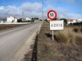
| + | I arrived in Azoia just in time to tank a bottle of water and a Red Bull before boarding the 201 back toward Sesimbra. The mist rolls in and out quickly in this part of the world, and it quickly overtook us as we left the cape. This time, I got off the bus early at Santana in order to be in time for the next connection back to Lisboa which also passed through that town. | ||
| + | |||
| + | And that's where I am now, writing the report on the bus home. Portugal's sun-parched countryside isn't much to look at, and I have to shower and head out again as soon as I get back to the hotel. | ||
| + | |||
| + | I hereby claim the Virgin Graticule achievement for the first geohash in 38,-9. In fact, unless I'm very much mistaken, I just deflowered the whole country. Hooray! | ||
| + | |||
| + | {{Davidc/Autumn_2009_series}} | ||
== Photos == | == Photos == | ||
| − | + | === Going to the hash === | |
| − | + | ||
| − | |||
| − | |||
| − | |||
<gallery perrow="4"> | <gallery perrow="4"> | ||
| + | Image:2009-10-07_38_-9_IMG_1809.JPG|First bus, Lisbon to Sesimbra. | ||
| + | Image:2009-10-07_38_-9_IMG_1811.JPG|Second bus, Sesimbra to Cabo Espichel. | ||
| + | Image:2009-10-07_38_-9_IMG_1812.JPG|View from the convent. | ||
| + | Image:2009-10-07_38_-9_IMG_1813.JPG|View from the convent. | ||
| + | Image:2009-10-07_38_-9_IMG_1814.JPG|The convent. | ||
| + | Image:2009-10-07_38_-9_IMG_1818.JPG|My bus in front of the convent. | ||
| + | Image:2009-10-07_38_-9_IMG_1821.JPG|A field of seagulls. | ||
| + | Image:2009-10-07_38_-9_IMG_1825.JPG|Green hides the hashpoint. | ||
| + | Image:2009-10-07_38_-9_IMG_1828.JPG|A blockage before the hash ... | ||
| + | Image:2009-10-07_38_-9_IMG_1829.JPG|... a sidetrack ... | ||
| + | Image:2009-10-07_38_-9_IMG_1830.JPG|... and a way through ... | ||
| + | Image:2009-10-07_38_-9_IMG_1831.JPG|... to the hashpoint. | ||
| + | </gallery> | ||
| + | === At the hash === | ||
| + | |||
| + | <gallery perrow="4"> | ||
| + | Image:2009-10-07_38_-9_IMG_1833.JPG|The hash-beetle. | ||
| + | Image:2009-10-07_38_-9_IMG_1837.JPG|GPS Proof. | ||
| + | Image:2009-10-07_38_-9_IMG_1844.JPG|Me & rabbitfox grinning. | ||
| + | Image:2009-10-07_38_-9_IMG_1853.JPG|rabbitfox impersonating davidc. | ||
| + | Image:2009-10-07_38_-9_IMG_1860.JPG|Signage. | ||
</gallery> | </gallery> | ||
| + | === Around the hash === | ||
| − | <!-- | + | <gallery perrow="4"> |
| − | < | + | Image:2009-10-07_38_-9_IMG_1863.JPG|Lighthouse. Actual Size!!! |
| − | [[ | + | Image:2009-10-07_38_-9_IMG_1866.JPG|Lighthouse. |
| − | -- | + | Image:2009-10-07_38_-9_IMG_1870.JPG|Geocache drop. |
| + | Image:2009-10-07_38_-9_IMG_1871.JPG|Back of the lighthouse. | ||
| + | Image:2009-10-07_38_-9_IMG_1872.JPG|Geocache bush. | ||
| + | Image:2009-10-07_38_-9_IMG_1873.JPG|The lighthouse should be over there, really. | ||
| + | Image:2009-10-07_38_-9_IMG_1876.JPG|Rocky. | ||
| + | Image:2009-10-07_38_-9_IMG_1884.JPG|Rockier. | ||
| + | Image:2009-10-07_38_-9_IMG_1885.JPG|Billions of years of rock. | ||
| + | Image:2009-10-07_38_-9_IMG_1888.JPG|The convent perched on top. | ||
| + | Image:2009-10-07_38_-9_IMG_1890.JPG|The convent and the rocks. | ||
| + | </gallery> | ||
| + | |||
| + | === The way back home === | ||
| + | |||
| + | <gallery perrow="4"> | ||
| + | Image:2009-10-07_38_-9_IMG_1893.JPG|A fresh ditch by the road. No doubt to bring FTTH to the residents of the lighthouse. | ||
| + | Image:2009-10-07_38_-9_IMG_1895.JPG|A dubious wall ... | ||
| + | Image:2009-10-07_38_-9_IMG_1897.JPG|... along the whole route back ... | ||
| + | Image:2009-10-07_38_-9_IMG_1896.JPG|... turned out to be an aqueduct for the convent. | ||
| + | Image:2009-10-07_38_-9_IMG_1898.JPG|How cool is that? | ||
| + | Image:2009-10-07_38_-9_IMG_1900.JPG|Typically half-arsed attempts at building houses. | ||
| + | Image:2009-10-07_38_-9_IMG_1901.JPG|Milestone. | ||
| + | Image:2009-10-07_38_-9_IMG_1904.JPG|That's not sunlight forcing my eyes shut, that's a river of sweat that even my big fat eyebrows can't divert. | ||
| + | Image:2009-10-07_38_-9_IMG_1905.JPG|A much more dignified photo of myself at this point. | ||
| + | Image:2009-10-07_38_-9_IMG_1907.JPG|The first town! Bus stop not far away. | ||
| + | Image:2009-10-07_38_-9_IMG_1921.JPG|rabbitfox double-checks the hashcards. | ||
| + | Image:2009-10-07_38_-9_IMG_1924.JPG|The fog quickly overtakes the bus. | ||
| + | Image:2009-10-07_38_-9_IMG_1930.JPG|The bridge ... | ||
| + | Image:2009-10-07_38_-9_IMG_1933.JPG|... crossing ... | ||
| + | Image:2009-10-07_38_-9_IMG_1940.JPG|... the strait ... | ||
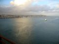
| + | Image:2009-10-07_38_-9_IMG_1945.JPG|... back to Lisbon. The docks. | ||
| + | Image:2009-10-07_38_-9_IMG_1954.JPG|And the aqueduct in the middle of the city. | ||
| + | </gallery> | ||
| + | |||
| + | == Ribbons == | ||
| + | |||
| + | <!-- One of you should give me the Hashcard achievement when you receive your card! --> | ||
| + | |||
| + | {{Graticule unlocked | ||
| + | | latitude = 38 | ||
| + | | longitude = -9 | ||
| + | | date = 2009-10-07 | ||
| + | | name = [[User:davidc|davidc]] | ||
| + | }} | ||
| + | {{Hashcard | ||
| + | | latitude = 38 | ||
| + | | longitude = -9 | ||
| + | | date = 2009-10-07 | ||
| + | | recipient = [[User:lyx|lyx]] and [[User:relet|relet]] | ||
| + | | name = rabbitfox and [[User:davidc|davidc]] | ||
| + | | image = P1050202.JPG | ||
| + | }} | ||
| − | |||
[[Category:Expeditions]] | [[Category:Expeditions]] | ||
| − | |||
[[Category:Expeditions with photos]] | [[Category:Expeditions with photos]] | ||
| − | |||
| − | |||
| − | |||
| − | |||
| − | |||
[[Category:Coordinates reached]] | [[Category:Coordinates reached]] | ||
| − | + | {{location|PT|15}} | |
| − | |||
| − | |||
| − | |||
| − | |||
| − | |||
| − | |||
| − | |||
| − | |||
| − | |||
Latest revision as of 06:22, 20 March 2024

| Wed 7 Oct 2009 in 38,-9: 38.4156129, -9.2083447 geohashing.info google osm bing/os kml crox |
Location
Cabo Espichel, near Sesimbra, Portugal.
Participants
Plans
Since I've been at the RIPE meeting in Lisbon all week, I've been waiting for a good set of coordinates to deflower the graticule with. You couldn't really ask for a better location than today's, on a picturesque headland about 50km south of the city.
Expedition
I ducked out of the afternoon sessions and set off on my adventure. Not really sure how reliable Portugese public transportation would be, it was with some trepidation that I waited for the 13:45 207 bus to Sesimbra. Luckily it was on time, and I had a few minutes to buy some hashcards in Sesimbra before my 14:50 connection on the 201 to Cabo Espichel. The journey thus far quite uneventful, I took the bus to the last stop, at the convent.
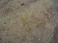
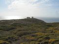
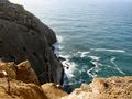
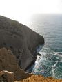
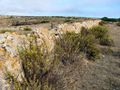
The cliff face exposes billions of years of history due to tectonic movement. Jurassic era dinosaur footprints are visible in the rock. Apparently the locals used to believe these were the footprints of the Virgin Mary. This explains why they built a convent at the top - though it doesn't explain why Christians aren't more terrified about the monumental size and clawed feet of their saviour's mother.
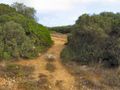
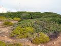
To ease me into hashing in a whole new country, the route to today's coordinates led me across a field. Of course, this being the rocky heathland of Portugal's coast, it was a field of seagulls instead of corn or horses. The hashpoint itself lay a little further in a lush strip of bushes.
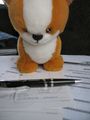
A hash-beetle occupied the exact coordinates, but I wasn't afraid of him. His miniature proportions made him seem almost cute; even rabbitfox could had squashed him with her dainty little paw. Coordinates reached, but with the sun beating down heavily, we didn't tarry long. I wrote out the hashcards (will you be lucky enough to receive one?), scratched a sign into the packed mud, watered a parched hash-bush nearby, and set off toward the lighthouse.
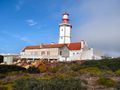
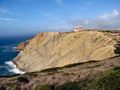
Unusually far inland for such an important lighthouse, the adjoining buildings today appear to be converted to apartments. Round the back we found the geocache GC173T7 into which I finally managed to drop a geocoin I've been carrying from Berlin through England.
Getting back was somewhat more problematic. The next bus heading back didn't come as far as Cabo Espichel, but only to Azoia. Fortunately it was not for another hour, so I had time to walk. On the way I followed an inexplicable wall along the entire route, which turned out to be a cute little aqueduct going to the convent.
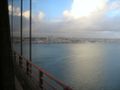
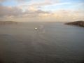
I arrived in Azoia just in time to tank a bottle of water and a Red Bull before boarding the 201 back toward Sesimbra. The mist rolls in and out quickly in this part of the world, and it quickly overtook us as we left the cape. This time, I got off the bus early at Santana in order to be in time for the next connection back to Lisboa which also passed through that town.
And that's where I am now, writing the report on the bus home. Portugal's sun-parched countryside isn't much to look at, and I have to shower and head out again as soon as I get back to the hotel.
I hereby claim the Virgin Graticule achievement for the first geohash in 38,-9. In fact, unless I'm very much mistaken, I just deflowered the whole country. Hooray!
This geohash was part of davidc's European tour in Autumn 2009:
England:
- 2009-09-27 50 -1 - Eastleigh, Hampshire.
- 2009-09-29 51 -0 - Stoke D'Abernon, Surrey (Failed: No Public Access)
- 1978-11-27 51 -0 on 2009-09-29 - my Origin Geohash in Bramley, Surrey.
- 2009-09-29 51 -1 - Ashmansworth. Speed racer!
- 2009-09-30 52 -2 - Herefordshire. Virgin graticule!
- 2009-09-30 52 -1 - Sibford Gower, Oxfordshire.
- 2009-10-01 51 -0 - Reigate, Surrey (Failed Ambassador)
Portugal:
- 2009-10-07 38 -9 - Cabo Espichel, Sesimbra
Photos
Going to the hash

First bus, Lisbon to Sesimbra.
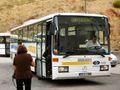
Second bus, Sesimbra to Cabo Espichel.
View from the convent.
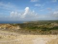
View from the convent.
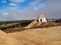
The convent.
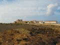
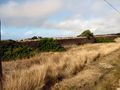
My bus in front of the convent.
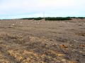
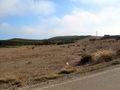
A field of seagulls.
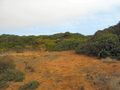
Green hides the hashpoint.
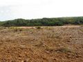
A blockage before the hash ...
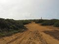
... a sidetrack ...
... and a way through ...
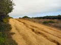
... to the hashpoint.


At the hash
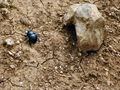
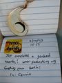
The hash-beetle.
GPS Proof.

Me & rabbitfox grinning.

rabbitfox impersonating davidc.
Signage.


Around the hash
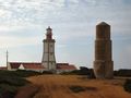
Lighthouse. Actual Size!!!
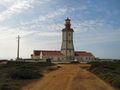
Lighthouse.
Geocache drop.
Back of the lighthouse.
Geocache bush.
The lighthouse should be over there, really.
Rocky.
Rockier.
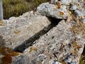
Billions of years of rock.
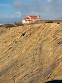
The convent perched on top.
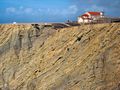
The convent and the rocks.


The way back home
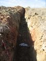
A fresh ditch by the road. No doubt to bring FTTH to the residents of the lighthouse.
A dubious wall ...
... along the whole route back ...
... turned out to be an aqueduct for the convent.

How cool is that?
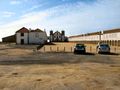
Typically half-arsed attempts at building houses.
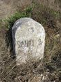
Milestone.

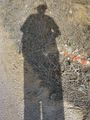
That's not sunlight forcing my eyes shut, that's a river of sweat that even my big fat eyebrows can't divert.
A much more dignified photo of myself at this point.
The first town! Bus stop not far away.
rabbitfox double-checks the hashcards.
The fog quickly overtakes the bus.
The bridge ...
... crossing ...
... the strait ...
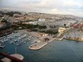
... back to Lisbon. The docks.
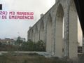
And the aqueduct in the middle of the city.


Ribbons
davidc earned the Graticule Unlocked Achievement
|
rabbitfox and davidc earned the Hashcard achievement
|