Difference between revisions of "2008-11-14 -53 -70"
imported>Relet |
m (per Renaming Proposal) |
||
| (9 intermediate revisions by 4 users not shown) | |||
| Line 1: | Line 1: | ||
Comment: How can anyone have such luck?! This one is withing WALKING distance in a graticule where it is reason enough to celebrate if a hash actually falls on land! (Now I'll be very disappointed if you don't get that one, and if I don't get a similar opportunity in Tromsø. ;-) [[User:Lyx|Lyx]] 17:04, 14 November 2008 (UTC) | Comment: How can anyone have such luck?! This one is withing WALKING distance in a graticule where it is reason enough to celebrate if a hash actually falls on land! (Now I'll be very disappointed if you don't get that one, and if I don't get a similar opportunity in Tromsø. ;-) [[User:Lyx|Lyx]] 17:04, 14 November 2008 (UTC) | ||
| − | |||
| − | |||
| − | |||
{{meetup graticule | {{meetup graticule | ||
| − | | map=<map lat= | + | | map=<map lat=-53 lon=-70 date=2008-11-14/> |
| − | | lat= | + | | lat=-53 |
| − | | lon= | + | | lon=-70 |
| − | | date= | + | | date=2008-11-14 |
}} | }} | ||
| − | |||
__NOTOC__ | __NOTOC__ | ||
== Participants == | == Participants == | ||
| + | * [[User:Relet|Relet]] 22:24, 17 November 2008 (UTC) | ||
== Plans == | == Plans == | ||
| + | I totally agree with the above comment. The hash lay right next to the ferry pier of Punta Arenas, Chile. Had I taken the ferry, I would have passed it by 15m. But it also was some 150m from the main highway to the north. So the only thing that could possibly spoil it was a fence. | ||
== Expedition == | == Expedition == | ||
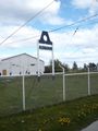
| + | After having packed all my stuff, and about to leave the town (I originally had planned to go hiking in Tierra del Fuego during maybe four to five days, including a lengthy expedition to wherever a hash may lie), I stopped the car near the docks and proceeded on foot. As predicted, there was a fence in front of the hash. Fortunately, it was the visitors parking of some shipping company and the gate was wide open. So I entered, and took a few pictures. I came as close as maybe 8-9m without trampling their lawn. There was an interesting battleship exposed on the docks, as the opposite lot is occupied by the Chilean navy. Yay for southermost easy geohash. :) | ||
== Tracklog == | == Tracklog == | ||
| + | tbd. | ||
| − | + | [[Category:Expeditions]] | |
| + | [[Category:Expeditions with photos]] | ||
| + | [[Category:Coordinates reached]] | ||
| − | <gallery | + | == Gallery == |
| − | Image: | + | <gallery widths="160px" align=center> |
| − | Image: | + | Image:20081114-53-70-P1020575.JPG|in the navy now |
| + | Image:20081114-53-70-P1020576.JPG|in front of the hash | ||
| + | Image:20081114-53-70-P1020577.JPG|stupid grin hidden by camera | ||
| + | Image:20081114-53-70-P1020578.JPG|ASMAR main building, hash on lawn to the right | ||
| + | Image:20081114-53-70-P1020579.JPG|ASMAR company logo | ||
</gallery> | </gallery> | ||
| − | + | == Achievements == | |
| − | + | {{South geohash|date=2008-11-14|latitude=-53|longitude=-70|name=[[User:relet|relet]]}} | |
| − | + | {{Graticule unlocked|date=2008-11-14|latitude=-53|longitude=-70|name=[[User:relet|relet]]}} | |
| − | + | {{location|CL|MA}} | |
| − | |||
| − | |||
| − | |||
| − | |||
| − | |||
| − | |||
| − | |||
| − | [[ | ||
| − | |||
| − | [[ | ||
| − | |||
| − | |||
| − | |||
Latest revision as of 06:42, 20 March 2024
Comment: How can anyone have such luck?! This one is withing WALKING distance in a graticule where it is reason enough to celebrate if a hash actually falls on land! (Now I'll be very disappointed if you don't get that one, and if I don't get a similar opportunity in Tromsø. ;-) Lyx 17:04, 14 November 2008 (UTC)
| Fri 14 Nov 2008 in -53,-70: -53.1225352, -70.8672240 geohashing.info google osm bing/os kml crox |
Participants
- Relet 22:24, 17 November 2008 (UTC)
Plans
I totally agree with the above comment. The hash lay right next to the ferry pier of Punta Arenas, Chile. Had I taken the ferry, I would have passed it by 15m. But it also was some 150m from the main highway to the north. So the only thing that could possibly spoil it was a fence.
Expedition
After having packed all my stuff, and about to leave the town (I originally had planned to go hiking in Tierra del Fuego during maybe four to five days, including a lengthy expedition to wherever a hash may lie), I stopped the car near the docks and proceeded on foot. As predicted, there was a fence in front of the hash. Fortunately, it was the visitors parking of some shipping company and the gate was wide open. So I entered, and took a few pictures. I came as close as maybe 8-9m without trampling their lawn. There was an interesting battleship exposed on the docks, as the opposite lot is occupied by the Chilean navy. Yay for southermost easy geohash. :)
Tracklog
tbd.
Gallery
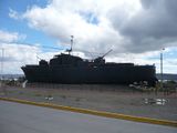
in the navy now
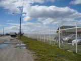
in front of the hash
stupid grin hidden by camera
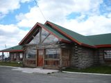
ASMAR main building, hash on lawn to the right
ASMAR company logo


Achievements
relet earned the South geohash achievement
|
relet earned the Graticule Unlocked Achievement
|