Difference between revisions of "2010-04-09 60 36"
imported>Danatar (double time-traveller airhash ;-)) |
(per Renaming Proposal) |
||
| (2 intermediate revisions by 2 users not shown) | |||
| Line 22: | Line 22: | ||
{{ | {{ | ||
| − | + | Graticule unlocked | latitude = 60 | longitude = 36 | date = 2010-04-09 | name = Danatar }}{{ | |
air geohash | latitude = 60 | longitude = 36 | date = 2010-04-09 | name = Danatar | image = 2010-04-09_60_36_departure.jpg | vehicle = Boeing 777-300ER }}{{ | air geohash | latitude = 60 | longitude = 36 | date = 2010-04-09 | name = Danatar | image = 2010-04-09_60_36_departure.jpg | vehicle = Boeing 777-300ER }}{{ | ||
Easy_geohash | latitude = 60 | longitude = 36 | date = 2010-04-09 | name = Danatar | image = 2010-04-09 60 36 neva.jpg }} | Easy_geohash | latitude = 60 | longitude = 36 | date = 2010-04-09 | name = Danatar | image = 2010-04-09 60 36 neva.jpg }} | ||
| Line 45: | Line 45: | ||
==Tracklog== | ==Tracklog== | ||
| − | The | + | http://www.everytrail.com/view_trip.php?trip_id=609337 The log file was originally composed of a route (all the locations) and many many waypoints (taken every second and each consisting of location + timestamp in Japanese time). I deleted most of the waypoints to save storage space, but it's still 1.2 MB. I left about one waypoint every hour and the waypoints near the two hashpoints. The complete tracklog (9 MB) is available on demand. Everytrail doesn't show the elevation to me, but I don't know why. |
==64 105== | ==64 105== | ||
| − | When looking at the tracklog, I found out that the one mentioned above was the second hashpoint I had passed on that day. At | + | When looking at the tracklog, I found out that the one mentioned above was the second hashpoint I had passed on that day. At 17:23 Japanese time (my internal clock) / 16:23 local time the plane passed within 80 metres of the 64 105 hashpoint, in a probably uninhabited part of the Krasnoyarsk region in Siberia. The 60 36 hashpoint I passed at 21:20 Japanese time / 16:20 local time. Thaaaat means: I visited the second hashpoint, 69 degrees latitude or 3435 km distant, three minutes before the first one, i.e. almost as a [[Time-Traveller Geohash]]. Or the plane was flying >1000 km backwards per minute. LOL |
| − | |||
[[Category:Expeditions]] | [[Category:Expeditions]] | ||
| Line 56: | Line 55: | ||
[[Category:Coordinates reached]] | [[Category:Coordinates reached]] | ||
[[Category:Danatar]] | [[Category:Danatar]] | ||
| + | {{location|RU|VLG}} | ||
Latest revision as of 11:32, 20 March 2024
| Fri 9 Apr 2010 in Zubovo, Russia: 60.2350413, 36.3068176 geohashing.info google osm bing/os kml crox |
Location
Today's location is near the towns(?) Markovo and Kiyno (sorry, no Cyrillic letters available).
Country: Russia; Federal district: Northwestern; Federal subject: Vologda Oblast (RU-VLG)
Expedition
Danatar
At the end of my trip to Japan, it was finally time to go home. I flew from Nagoya to Tokyo, changed the plane and started towards Europe. During the trip, I had my new GPS logger active and every few minutes I looked at it to make sure it still had reception and to check if we were approaching any hashpoints.
We passed meridian after meridian without hitting a hashpoint. The longitude coordinates were counting down rapidly, latitude was creeping slowly as we had a mostly western route. While flying over Siberia, we came very close to at least two hashpoints, but passed them by. While flying through the 60 36 graticule and approaching the longitude of the hashpoint, the latitude offset was nearing the desired 14 minutes 6 seconds. But would I reach both at the same time? My heart was beating faster. As I came nearer and nearer to the hashpoint, I set my camera to rapid mode and held the release button down. Careful checking of the pictures afterwards told me that I had been near enough to the hashpoint. Hooray! Pictures out of the window and of my mad grin followed. The plane continued on its route, as if nothing had happened.
Danatar earned the Graticule Unlocked Achievement
|
Danatar earned the Air geohash achievement
|
Danatar has visited an Easy Geohash
|
With me, there were lots of people (up to 292 passengers + crew, but I saw some spare seats; there were 71 in my group) at the hashpoint, but I guess they don't count as geohashers ;-) Also, the outside temperature at the hashpoint according to the plane's display was -51 °C.
Does this count as public transport?
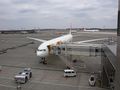
The mode of transport, a Boeing 777-300ER
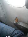
GPS receiver working. Must not be moved, else signal is lost.
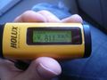
The desired coordinates, noted for quick look-up.
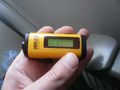
GPS, 6" from the hashpoint
10480 metres above sea level, 811 km/h.

Coordinates reached! MUHAHAHAHA!

Looking out of the window to the north, the hashpoint is under and behind the plane.
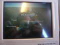
Location indicator on the plane's multi-purpose monitor.
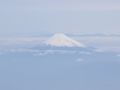
Fuji, passed earlier
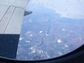
Yenisei River near 66° 87.5°
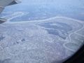
Lake Ladoga and Neva River east of Saint Petersburg


Tracklog
http://www.everytrail.com/view_trip.php?trip_id=609337 The log file was originally composed of a route (all the locations) and many many waypoints (taken every second and each consisting of location + timestamp in Japanese time). I deleted most of the waypoints to save storage space, but it's still 1.2 MB. I left about one waypoint every hour and the waypoints near the two hashpoints. The complete tracklog (9 MB) is available on demand. Everytrail doesn't show the elevation to me, but I don't know why.
64 105
When looking at the tracklog, I found out that the one mentioned above was the second hashpoint I had passed on that day. At 17:23 Japanese time (my internal clock) / 16:23 local time the plane passed within 80 metres of the 64 105 hashpoint, in a probably uninhabited part of the Krasnoyarsk region in Siberia. The 60 36 hashpoint I passed at 21:20 Japanese time / 16:20 local time. Thaaaat means: I visited the second hashpoint, 69 degrees latitude or 3435 km distant, three minutes before the first one, i.e. almost as a Time-Traveller Geohash. Or the plane was flying >1000 km backwards per minute. LOL