Difference between revisions of "2021-04-23 62 29"
(Created page with "{{Subst:Expedition}}") |
m (subst-ing) |
||
| (5 intermediate revisions by 2 users not shown) | |||
| Line 1: | Line 1: | ||
| − | + | {{meetup graticule | |
| + | | lat=62 | ||
| + | | lon=29 | ||
| + | | date=2021-04-23 | ||
| + | }} | ||
| + | __NOTOC__ | ||
| + | == Location == | ||
| + | On the top of the Utranharju ridge, only 373 metres from [[2021-04-10 62 29]]. | ||
| − | + | The point on a topographic map: {{MapSiteLink | N = 6948427.6 | E = 647341.4 | title = Geohash+2021-04-23+62+29}} | |
| − | + | == Participants == | |
| − | + | * [[User:Kripakko|Kripakko]] | |
| − | + | == Expedition == | |
| − | + | This hashpoint happened to be very close to the one I visited 13 days ago, and I reckoned that the most convenient way to approach it would be along the same roads as then. I could also have approached from the south along the sandy roads, but I had no idea whether they would actually be traversable. So I decided to do a déjà vu trip and follow the same route to the ridge where I would have to walk a slightly longer distance. | |
| − | |||
| − | |||
| − | |||
| − | |||
| − | |||
| − | |||
| − | |||
| − | + | I had much stuff to do during the day, and I was at home at about half past eight. If I would leave for the geohash immediately, I would have just barely enough daylight left (sunset was at 20:52) that I could reach the hashpoint while being able to take photos, so I did just that. I quickly changed my clothes and shoes and left. Being wiser after the previous expedition, I wore my Nokian rubber boots with 40-cm shafts that would definitely be enough for any amount of snow that I would encounter. | |
| − | |||
| − | |||
| − | + | I parked the bicycle in the same place as the last time. The maintenance road of the mast was clearer now but still a little muddy, so I did not want to cycle on it with my narrow tyres. I walked up to the skiing track, taking photos of familiar places on the way, and continued to the hashpoint via the mast. I could also have taken a shorter, straighter path from the parking site, but I wanted to follow the same route. It was getting progressively darker but not too dark yet for the mobile phone camera. The deepest patch of snow that I encountered on my way was about 20 cm deep. There was probably more on the bottoms of some deep depressions, but I was not adventurous enough to go in them. | |
| − | |||
| − | + | The hashpoint was located in a pine forest next to a small forest road. I was barely able to take the proof photos and a selfie. Despite still having enough daylight to see with my eyes, the camera was struggling to focus and to take sharp photos because the exposure times needed to be long. Also, the exposures and white balances turned out inconsistent across the photos. Had I had a systems camera and a stand with me, I would have had no problems taking photos. The mobile phone camera has poor optics and a weak flash, so it is not really suitable for dark conditions. It was easy this way though, and the photos were acceptable at least. | |
| − | |||
| − | + | I returned along the same route and eventually was back at the bicycle again. At this point, it was getting really dark, but it was no problem on the road. I took a slightly shorter route back home than the last time, and indeed according to my GPS receiver, I ended up cycling 13.0 km and walking 2.0 km in total. | |
| − | |||
== Photos == | == Photos == | ||
| − | + | Compare the photos to the ones on the previous expedition report: [[2021-04-10 62 29]]. | |
| − | + | ||
| − | |||
<gallery perrow="5"> | <gallery perrow="5"> | ||
| + | Image:2021-04-23_62_29_01-bicycle.jpg | Where I parked the bicycle. {{MapSiteLink | N=6948763 | E=647496 | title=Photo+1}} | ||
| + | Image:2021-04-23_62_29_02-uphill.jpg | The hill where I buttslid previously. Not possible anymore, but one could walk it. {{MapSiteLink | N=6948860 | E=647267 | title=Photos+2+%26+10}} | ||
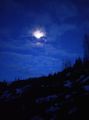
| + | Image:2021-04-23_62_29_03-moon1.jpg | The moon is shining behind the clouds. {{MapSiteLink | N=6948706 | E=647101 | title=Photo+3}} | ||
| + | Image:2021-04-23_62_29_04-skitrack.jpg | How the skiing track looks now, impossible to ski because there is no snow. {{MapSiteLink | N=6948654 | E=647125 | title=Photo+4}} | ||
| + | Image:2021-04-23_62_29_05-gpsr1.jpg | Proof of location. {{MapSiteLink | N=6948428 | E=647341 | title=Photos+5%E2%80%937}} | ||
| + | Image:2021-04-23_62_29_06-gpsr2.jpg | Proof of date. {{MapSiteLink | N=6948428 | E=647341 | title=Photos+5%E2%80%937}} | ||
| + | Image:2021-04-23_62_29_07-selfie.jpg | Selfie at the hashpoint. {{MapSiteLink | N=6948428 | E=647341 | title=Photos+5%E2%80%937}} | ||
| + | Image:2021-04-23_62_29_08-depression.jpg | A depression that probably still has at least half a metre of snow on the bottom. I did not go there to try though. {{MapSiteLink | N=6948732 | E=647099 | title=Photo+8}} | ||
| + | Image:2021-04-23_62_29_09-footprints.jpg | My footprints from the previous expedition. {{MapSiteLink | N=6948766 | E=647113 | title=Photo+9}} | ||
| + | Image:2021-04-23_62_29_10-moon2.jpg | A final look at the moon. {{MapSiteLink | N=6948860 | E=647267 | title=Photos+2+%26+10}} | ||
</gallery> | </gallery> | ||
== Achievements == | == Achievements == | ||
{{#vardefine:ribbonwidth|800px}} | {{#vardefine:ribbonwidth|800px}} | ||
| − | |||
| − | |||
| − | |||
| − | |||
| − | |||
| − | |||
| − | |||
| − | |||
| − | |||
| − | |||
| − | |||
| − | |||
| − | + | {{land geohash | name = Kripakko | latitude = 62 | longitude = 29 | date = 2021-04-23}} | |
| + | {{bicycle geohash | name = Kripakko | latitude = 62 | longitude = 29 | date = 2021-04-23 | distance = 13.0 km | bothways = true}} | ||
| − | |||
[[Category:Expeditions]] | [[Category:Expeditions]] | ||
| − | |||
[[Category:Expeditions with photos]] | [[Category:Expeditions with photos]] | ||
| − | |||
| − | |||
| − | |||
| − | |||
| − | |||
[[Category:Coordinates reached]] | [[Category:Coordinates reached]] | ||
| − | + | {{location|FI|13}} | |
| − | |||
| − | |||
| − | |||
| − | |||
| − | |||
| − | |||
| − | |||
| − | |||
| − | |||
| − | |||
| − | |||
| − | |||
| − | |||
| − | |||
| − | |||
| − | |||
| − | |||
Latest revision as of 20:31, 24 May 2024
| Fri 23 Apr 2021 in 62,29: 62.6369900, 29.8739410 geohashing.info google osm bing/os kml crox |
Location
On the top of the Utranharju ridge, only 373 metres from 2021-04-10 62 29.
The point on a topographic map: [11]
Participants
Expedition
This hashpoint happened to be very close to the one I visited 13 days ago, and I reckoned that the most convenient way to approach it would be along the same roads as then. I could also have approached from the south along the sandy roads, but I had no idea whether they would actually be traversable. So I decided to do a déjà vu trip and follow the same route to the ridge where I would have to walk a slightly longer distance.
I had much stuff to do during the day, and I was at home at about half past eight. If I would leave for the geohash immediately, I would have just barely enough daylight left (sunset was at 20:52) that I could reach the hashpoint while being able to take photos, so I did just that. I quickly changed my clothes and shoes and left. Being wiser after the previous expedition, I wore my Nokian rubber boots with 40-cm shafts that would definitely be enough for any amount of snow that I would encounter.
I parked the bicycle in the same place as the last time. The maintenance road of the mast was clearer now but still a little muddy, so I did not want to cycle on it with my narrow tyres. I walked up to the skiing track, taking photos of familiar places on the way, and continued to the hashpoint via the mast. I could also have taken a shorter, straighter path from the parking site, but I wanted to follow the same route. It was getting progressively darker but not too dark yet for the mobile phone camera. The deepest patch of snow that I encountered on my way was about 20 cm deep. There was probably more on the bottoms of some deep depressions, but I was not adventurous enough to go in them.
The hashpoint was located in a pine forest next to a small forest road. I was barely able to take the proof photos and a selfie. Despite still having enough daylight to see with my eyes, the camera was struggling to focus and to take sharp photos because the exposure times needed to be long. Also, the exposures and white balances turned out inconsistent across the photos. Had I had a systems camera and a stand with me, I would have had no problems taking photos. The mobile phone camera has poor optics and a weak flash, so it is not really suitable for dark conditions. It was easy this way though, and the photos were acceptable at least.
I returned along the same route and eventually was back at the bicycle again. At this point, it was getting really dark, but it was no problem on the road. I took a slightly shorter route back home than the last time, and indeed according to my GPS receiver, I ended up cycling 13.0 km and walking 2.0 km in total.
Photos
Compare the photos to the ones on the previous expedition report: 2021-04-10 62 29.

Where I parked the bicycle. [1]
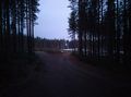
The hill where I buttslid previously. Not possible anymore, but one could walk it. [2]
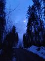
The moon is shining behind the clouds. [3]
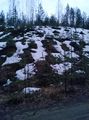
How the skiing track looks now, impossible to ski because there is no snow. [4]
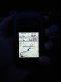
Proof of location. [5]
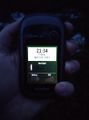
Proof of date. [6]
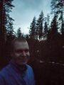
Selfie at the hashpoint. [7]
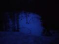
A depression that probably still has at least half a metre of snow on the bottom. I did not go there to try though. [8]
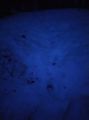
My footprints from the previous expedition. [9]
A final look at the moon. [10]


Achievements
Kripakko earned the Land geohash achievement
|
Kripakko earned the Bicycle geohash achievement
|