Difference between revisions of "2022-04-16 19 -155"
(Plans added) |
m (subst-ing) |
||
| (9 intermediate revisions by 2 users not shown) | |||
| Line 1: | Line 1: | ||
| + | [[Image:{{{image|2022-04-16_19_-155_pah_013.jpeg}}}|330px|thumb|right]] | ||
{{meetup graticule | {{meetup graticule | ||
| − | | lat= | + | | lat=19 |
| − | | lon= | + | | lon=-155 |
| − | | date= | + | | date=2022-04-16 |
}}<!-- edit as necessary --> | }}<!-- edit as necessary --> | ||
__NOTOC__ | __NOTOC__ | ||
| Line 10: | Line 11: | ||
== Participants == | == Participants == | ||
| − | + | * [[User:Pah|pah]] [[File:U+110DB.png|middle|6px|link=User:Pah]] ([[2020-07-01 48 14|prev]]| [[2022-04-23 48 14|next]]) | |
| − | -- | + | * lia |
== Plans == | == Plans == | ||
| − | + | [[User:Pah|pah]] [[File:U+110DB.png|middle|6px|link=User:Pah]] and lia plan to be there at around 4pm for the [[Saturday meetup]]. | |
| − | |||
| − | |||
== Expedition == | == Expedition == | ||
| − | + | ||
| + | After almost three weeks on different Hawaiian islands with no luck of any hashpoints in reach, [[User:Pah|pah]] [[File:U+110DB.png|middle|6px|link=User:Pah]] and lia finally went to an expedition today. The hashpoint was conveniently located around 30 kilometers from their accommodation, close to highway 11 in the [https://dlnr.hawaii.gov/dsp/parks/hawaii/manuka-state-wayside/ Manukā Natural Area Reserve]. From the highway, they continued by foot (as advised on a sign) on the Manukā Bay Road for around 2.5 kilometers in between a forest and a lava field. | ||
| + | |||
| + | Afterwards, they left the path towards the lava field for about 200m, treading lightly to avoid harming any plants (or spiderwebs) already growing in the lava. The light drizzle turned into proper rain while they were trying to climb through the sharp rocks. Still, they were very happy to make such good progress. | ||
| + | |||
| + | At around 4:15pm, they arrived at the hashpoint, did the obligatory hash dance and built a small hash marker from little twigs found in the area. Afterwards, they took some pictures but left rather quickly due to the ongoing rain. On their way back on the path, they found a few old batteries lying around, which they removed from the natural reserve to avoid their leaking chemicals to harm the plants reshaping the lava into a nice forest again. | ||
| + | |||
| + | All in all, a very successful expedition and certainly a highlight of their visit to Hawai‘i! | ||
== Tracklog == | == Tracklog == | ||
| − | + | ||
| + | lia tracked most of the walk with her Garmin watch. The „navigation“ from the road towards the hash was done by [[User:Pah|pah]] [[File:U+110DB.png|middle|6px|link=User:Pah]] via phone and GeoHashDroid app, resulting in a rather inefficient approach. The hash dance was done by [[User:Pah|pah]] [[File:U+110DB.png|middle|6px|link=User:Pah]] and thus not tracked here in detail. The way back to the road was led by lia and her watch, following a nice and almost straight line. | ||
| + | |||
| + | {{tracklog | 2022-04-16 19 -155 pah tracklog.gpx}} | ||
== Photos == | == Photos == | ||
| − | |||
| − | |||
| − | |||
<gallery perrow="5"> | <gallery perrow="5"> | ||
| + | |||
| + | Image:2022-04-16 19 -155 pah 001.jpeg | Leaving the highway | ||
| + | Image:2022-04-16 19 -155 pah 002.jpeg | Advice to continue by foot | ||
| + | Image:2022-04-16 19 -155 pah 003.jpeg | Entrance of the Natural Reserve | ||
| + | Image:2022-04-16 19 -155 pah 004.png | Remaining path to the hash | ||
| + | Image:2022-04-16 19 -155 pah 005.jpeg | Entering the park | ||
| + | |||
| + | Image:2022-04-16 19 -155 pah 006.jpeg | Forest to the left of the road | ||
| + | Image:2022-04-16 19 -155 pah 007.jpeg | Leaving the road towards the lava field | ||
| + | Image:2022-04-16 19 -155 pah 008.jpeg | Hash dance | ||
| + | Image:2022-04-16 19 -155 pah 009.png | Proof #1 | ||
| + | Image:2022-04-16 19 -155 pah 010.png | Proof #2 | ||
| + | |||
| + | Image:2022-04-16 19 -155 pah 011.jpeg | Hash marker | ||
| + | Image:2022-04-16 19 -155 pah 012.jpeg | [[:Category:Grins|Stupid grin]]™ | ||
| + | Image:2022-04-16 19 -155 pah 013.jpeg | View over the hash towards the ocean (spot the marker!) | ||
| + | Image:2022-04-16 19 -155 pah 014.jpeg | Old batteries found on the road | ||
| + | Image:2022-04-16 19 -155 pah 015.jpeg | Back from the park, grin #2 | ||
| + | |||
</gallery> | </gallery> | ||
| Line 35: | Line 60: | ||
<!-- Add any achievement ribbons you earned below, or remove this section --> | <!-- Add any achievement ribbons you earned below, or remove this section --> | ||
| − | + | {{Globetrotter6 | |
| − | + | | name = [[User:Pah|pah]] [[File:U+110DB.png|middle|6px|link=User:Pah]] | |
| − | + | | australia = true | |
| + | | europe = true | ||
| + | | continents = 2 | ||
| + | }} | ||
| − | + | {{Ribbon | |
| + | | color = orange | ||
| + | | icon = West.JPG | ||
| + | | user = [[User:Pah|pah]] [[File:U+110DB.png|middle|6px|link=User:Pah]] | ||
| + | | achievement = [[West geohash achievement]] | ||
| + | | action = reaching the [https://geohashing.info/s/2022-04-16/19,-155 (19, -155) geohash] on [[2022-04-16 19 -155|2022-04-16]] | ||
| + | | category = West geohash achievement | ||
| + | }} | ||
| − | + | {{Geotrash | |
| − | |||
| − | |||
| − | |||
| − | + | | latitude = 19 | |
| + | | longitude = -155 | ||
| + | | date = 2022-04-16 | ||
| + | | name = [[User:Pah|pah]] [[File:U+110DB.png|middle|6px|link=User:Pah]] | ||
| + | | image = 2022-04-16 19 -155 pah 014.jpeg | ||
| + | }} | ||
| − | |||
[[Category:Expeditions]] | [[Category:Expeditions]] | ||
| − | |||
[[Category:Expeditions with photos]] | [[Category:Expeditions with photos]] | ||
| − | |||
| − | |||
| − | |||
| − | |||
| − | |||
[[Category:Coordinates reached]] | [[Category:Coordinates reached]] | ||
| − | + | {{location|US|HI|HA}} | |
| − | |||
| − | |||
| − | |||
| − | |||
| − | |||
| − | |||
| − | |||
| − | |||
| − | |||
| − | |||
| − | |||
| − | |||
| − | |||
| − | |||
| − | |||
| − | |||
Latest revision as of 20:46, 24 May 2024

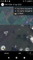
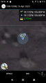
| Sat 16 Apr 2022 in 19,-155: 19.1154182, -155.8585289 geohashing.info google osm bing/os kml crox |
Location
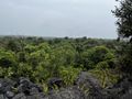
On a lava field in the Manukā Natural Area Reserve in South Kona.
Participants
Plans
pah ![]() and lia plan to be there at around 4pm for the Saturday meetup.
and lia plan to be there at around 4pm for the Saturday meetup.
Expedition
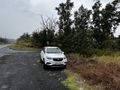
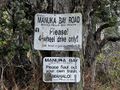
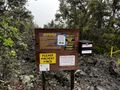
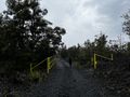
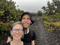
After almost three weeks on different Hawaiian islands with no luck of any hashpoints in reach, pah ![]() and lia finally went to an expedition today. The hashpoint was conveniently located around 30 kilometers from their accommodation, close to highway 11 in the Manukā Natural Area Reserve. From the highway, they continued by foot (as advised on a sign) on the Manukā Bay Road for around 2.5 kilometers in between a forest and a lava field.
and lia finally went to an expedition today. The hashpoint was conveniently located around 30 kilometers from their accommodation, close to highway 11 in the Manukā Natural Area Reserve. From the highway, they continued by foot (as advised on a sign) on the Manukā Bay Road for around 2.5 kilometers in between a forest and a lava field.
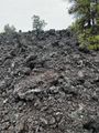
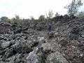
Afterwards, they left the path towards the lava field for about 200m, treading lightly to avoid harming any plants (or spiderwebs) already growing in the lava. The light drizzle turned into proper rain while they were trying to climb through the sharp rocks. Still, they were very happy to make such good progress.
At around 4:15pm, they arrived at the hashpoint, did the obligatory hash dance and built a small hash marker from little twigs found in the area. Afterwards, they took some pictures but left rather quickly due to the ongoing rain. On their way back on the path, they found a few old batteries lying around, which they removed from the natural reserve to avoid their leaking chemicals to harm the plants reshaping the lava into a nice forest again.
All in all, a very successful expedition and certainly a highlight of their visit to Hawai‘i!
Tracklog
lia tracked most of the walk with her Garmin watch. The „navigation“ from the road towards the hash was done by pah ![]() via phone and GeoHashDroid app, resulting in a rather inefficient approach. The hash dance was done by pah
via phone and GeoHashDroid app, resulting in a rather inefficient approach. The hash dance was done by pah ![]() and thus not tracked here in detail. The way back to the road was led by lia and her watch, following a nice and almost straight line.
and thus not tracked here in detail. The way back to the road was led by lia and her watch, following a nice and almost straight line.
Photos
Leaving the highway
Advice to continue by foot
Entrance of the Natural Reserve
Remaining path to the hash
Entering the park
Forest to the left of the road
Leaving the road towards the lava field
Hash dance

Proof #1
Proof #2
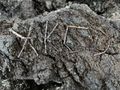
Hash marker
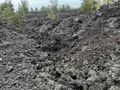
View over the hash towards the ocean (spot the marker!)
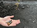
Old batteries found on the road
Back from the park, grin #2


Achievements
pah
|
pah
|
pah
|