Difference between revisions of "2024-08-04 41 -87"
Tarasaurus (talk | contribs) (planning) |
m (Location) |
||
| (One intermediate revision by one other user not shown) | |||
| Line 10: | Line 10: | ||
== Expedition == | == Expedition == | ||
| − | + | ===Expedition Tarasaurus=== | |
| + | Unlike [[2024-07-20_41_-88|my last attempt]] at a geohash I actually took the time to prepare for a little bushwhacking in the woods by dressing in long cargo pants and sturdy shoes. I got the 11:05 Metra train into Chicago, which turned out to be much busier than I was expecting. Apparently a music festival was ongoing downtown, so the train was full of festival goers in cute outfits. On arrival at Union Station I walked a few blocks over to the Blue Line subway, part of the Chicago 'L' light rail system. The 'L' name is short for 'elevated', which is how you know it's underground. From there I took the Blue Line out to Rosemont, the last station before O'Hare, one of the busiest airports in the world. There were a lot fewer people on the train heading away from Chicago, which I was grateful for since I get socially anxious in crowds. | ||
| + | |||
| + | Once in Rosemont, I walked through a deserted office building campus (closed on Sundays) which was directly under the approach path for one of O'Hare's many runways. It was certainly a unique experience having big passenger jets streaking by just a couple hundred or so feet overhead. I'm sure this area is a favorite for aviation photographers but I was equipped with just a cell phone camera today. Then I came to Higgins Road, which I would need to walk along to cross the Des Plaines river. Interestingly, in typical fashion in the US, there was no sidewalk before or after the bridge, but one was present on the bridge itself. I was nervous that it may be difficult to cross Higgins Road because it looked to be a pretty major road from online, but traffic was very light so I had no issue. Directly adjacent to the bridge was a turn off to a vehicle track going into the forest preserve. Much further down the road was a cycling trail that ran through the woods, but that would require a lot more bushwhacking so I began my hike down the grassy track instead. | ||
| + | |||
| + | It didn't take long before I reached a grassy clearing near the hash point. At the far end was a metal box of some kind that looked like some type of equipment box. There appeared to be a faint trail of stepped on grass leading to it, leading me to consider that perhaps it was a geocache of some kind but I declined to investigate further. I quickly located the hash point just a few steps off the track I had been following. All of the grass had been stomped down in a small circle directly where the hash point was indicated. Had someone already visited this hash point? Was it someone active on the wiki, or a ninja? So many questions, but I have no doubt there were other geohashers that had beaten me here. I pulled Sylvie out of my pocket for a photo and waited a couple minutes to get a photo of a plane flying overhead from the hash point to show just how close to the approach path it was. By my estimation the point was about 800 feet (240m) north of the planes, which means that roughly 1/3 of all travelers flying into O'Hare today also qualified for the [[Air_geohash_achievement]]. Most accidental geohashers in one day ever? | ||
| + | |||
| + | After achieving my goal I headed back to the Rosemont station and took the Blue Line and Metra back home. It was fairly warm out (90°F,32°C) so I ended up hot and dehydrated on the way. Next time I'll remember to bring some water. | ||
== Photos == | == Photos == | ||
| − | |||
| − | |||
| − | |||
<gallery perrow="5"> | <gallery perrow="5"> | ||
| + | Image:2024-08-04 41 -87 tren.jpg|CTA Blue Line train | ||
| + | Image:2024-08-04 41 -87 plen.jpg|Standing directly under the approach to O'Hare | ||
| + | Image:2024-08-04 41 -87 hash1.jpg|The clearing with the hash point and metal box at the far end | ||
| + | Image:2024-08-04 41 -87 hash2.jpg|Someone has already been here! | ||
| + | Image:2024-08-04 41 -87 sylvie.jpg|Sylvie and I at the point | ||
| + | Image:2024-08-04 41 -87 plen2.jpg|Plane on approach as seen from the hash point | ||
| + | Image:2024-08-04 41 -87 proof1.png|Geohash Droid screenshot proof | ||
</gallery> | </gallery> | ||
== Achievements == | == Achievements == | ||
{{#vardefine:ribbonwidth|100%}} | {{#vardefine:ribbonwidth|100%}} | ||
| − | + | {{land geohash | |
| − | + | | latitude = 41 | |
| − | + | | longitude = -87 | |
| − | + | | date = 2024-08-04 | |
| − | + | | name = Tarasaurus | |
| − | + | }} | |
| − | + | {{Public transport geohash | |
| − | + | | latitude = 41 | |
| − | + | | longitude = -87 | |
| − | + | | date = 2024-08-04 | |
| − | + | | busline = Metra & the L | |
| − | + | | name = Tarasaurus | |
| + | }} | ||
[[Category:Expeditions]] | [[Category:Expeditions]] | ||
| − | |||
[[Category:Expeditions with photos]] | [[Category:Expeditions with photos]] | ||
| − | |||
| − | |||
| − | |||
| − | |||
[[Category:Coordinates reached]] | [[Category:Coordinates reached]] | ||
| − | + | {{location|US|IL|CO}} | |
| − | |||
| − | |||
| − | |||
| − | |||
| − | |||
| − | |||
| − | |||
| − | |||
| − | |||
| − | |||
| − | |||
| − | |||
| − | |||
Latest revision as of 11:42, 5 August 2024
| Sun 4 Aug 2024 in 41,-87: 41.9904624, -87.8555386 geohashing.info google osm bing/os kml crox |
Contents
Location
In the woods near O'Hare Airport in Rosemont.
Participants
Plans
Tarasaurus - Planning to take the Blue Line out to Rosemont and walk to the hash from there.
Expedition
Expedition Tarasaurus
Unlike my last attempt at a geohash I actually took the time to prepare for a little bushwhacking in the woods by dressing in long cargo pants and sturdy shoes. I got the 11:05 Metra train into Chicago, which turned out to be much busier than I was expecting. Apparently a music festival was ongoing downtown, so the train was full of festival goers in cute outfits. On arrival at Union Station I walked a few blocks over to the Blue Line subway, part of the Chicago 'L' light rail system. The 'L' name is short for 'elevated', which is how you know it's underground. From there I took the Blue Line out to Rosemont, the last station before O'Hare, one of the busiest airports in the world. There were a lot fewer people on the train heading away from Chicago, which I was grateful for since I get socially anxious in crowds.
Once in Rosemont, I walked through a deserted office building campus (closed on Sundays) which was directly under the approach path for one of O'Hare's many runways. It was certainly a unique experience having big passenger jets streaking by just a couple hundred or so feet overhead. I'm sure this area is a favorite for aviation photographers but I was equipped with just a cell phone camera today. Then I came to Higgins Road, which I would need to walk along to cross the Des Plaines river. Interestingly, in typical fashion in the US, there was no sidewalk before or after the bridge, but one was present on the bridge itself. I was nervous that it may be difficult to cross Higgins Road because it looked to be a pretty major road from online, but traffic was very light so I had no issue. Directly adjacent to the bridge was a turn off to a vehicle track going into the forest preserve. Much further down the road was a cycling trail that ran through the woods, but that would require a lot more bushwhacking so I began my hike down the grassy track instead.
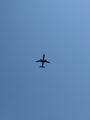
It didn't take long before I reached a grassy clearing near the hash point. At the far end was a metal box of some kind that looked like some type of equipment box. There appeared to be a faint trail of stepped on grass leading to it, leading me to consider that perhaps it was a geocache of some kind but I declined to investigate further. I quickly located the hash point just a few steps off the track I had been following. All of the grass had been stomped down in a small circle directly where the hash point was indicated. Had someone already visited this hash point? Was it someone active on the wiki, or a ninja? So many questions, but I have no doubt there were other geohashers that had beaten me here. I pulled Sylvie out of my pocket for a photo and waited a couple minutes to get a photo of a plane flying overhead from the hash point to show just how close to the approach path it was. By my estimation the point was about 800 feet (240m) north of the planes, which means that roughly 1/3 of all travelers flying into O'Hare today also qualified for the Air_geohash_achievement. Most accidental geohashers in one day ever?
After achieving my goal I headed back to the Rosemont station and took the Blue Line and Metra back home. It was fairly warm out (90°F,32°C) so I ended up hot and dehydrated on the way. Next time I'll remember to bring some water.
Photos
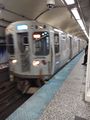
CTA Blue Line train
Standing directly under the approach to O'Hare
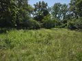
The clearing with the hash point and metal box at the far end
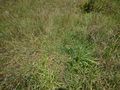
Someone has already been here!
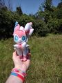
Sylvie and I at the point
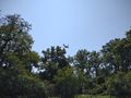
Plane on approach as seen from the hash point
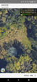
Geohash Droid screenshot proof


Achievements
Tarasaurus earned the Land geohash achievement
|
Tarasaurus earned the Public transport geohash achievement
|