Difference between revisions of "Nykøbing Falster, Denmark"
From Geohashing
imported>Mtu |
m (Marking as inactive due to no recent expeditions) |
||
| (12 intermediate revisions by 6 users not shown) | |||
| Line 14: | Line 14: | ||
}} | }} | ||
| − | + | {{Today's location|lat=54|lon=11}} | |
According to [[Land usage]], the chance for your hash to fall into one of the following areas is: | According to [[Land usage]], the chance for your hash to fall into one of the following areas is: | ||
| Line 35: | Line 35: | ||
|'''Denmark''' | |'''Denmark''' | ||
|15.61% | |15.61% | ||
| − | | | + | |58.75% |
|- | |- | ||
|'''Germany''' | |'''Germany''' | ||
|10.96% | |10.96% | ||
| − | | | + | |41.25% |
| + | |} | ||
| + | |||
| + | ===Maps and stats=== | ||
| + | [[File:Region 54,11 Admin 4.svg|200px]] | ||
| + | {| class="wikitable" | ||
| + | !Name!!Code!!area type!!Country!!Geohash<br />probability | ||
| + | |- | ||
| + | |<span style="color:rgba(237,244,168,255)">■</span> Sjælland||DK-85||land||Denmark||23.5% | ||
| + | |- | ||
| + | |<span style="color:rgba(255,204,204,255)">■</span> Mecklenburg-Vorpommern||DE-MV||land||Germany||6.7% | ||
| + | |- | ||
| + | |<span style="color:rgba(237,244,168,255)">■</span> Schleswig-Holstein||DE-SH||land||Germany||4.2% | ||
| + | |- | ||
| + | |<span style="color:rgba(219,212,249,255)">■</span> Denmark||DK||incl. waters||Denmark||45.0% | ||
| + | |- | ||
| + | |<span style="color:rgba(226,219,229,255)">■</span> Mecklenburg-Vorpommern||DE-MV||incl. waters||Germany||23.2% | ||
| + | |- | ||
| + | |<span style="color:rgba(217,239,211,255)">■</span> Schleswig-Holstein||DE-SH||incl. waters||Germany||20.7% | ||
|} | |} | ||
| Line 45: | Line 63: | ||
None, yet. | None, yet. | ||
| − | {| | + | ==Expeditions== |
| − | + | * {{flag|DE}} [[2023-10-05 54 11]] - [[User:Fippe|Fippe]] visited Kellenhusen. | |
| − | + | * {{flag|DK}} [[2015-07-21 54 11]] - [[User:Q-Owl|Q-Owl]] & [[User:Q-Owla|Q-Owla]] visited Lolland. | |
| − | + | * {{flag|DE}} [[2010-11-14 54 11]] - [[User:Mtu|mtu]] & his girlfriend visited Fehmarn. | |
| − | |||
| − | |||
| − | | | ||
| − | |||
| − | * [[2010-11-14 54 11]] | ||
| − | | | ||
| − | |||
| − | {{ | + | {{Graticule unlocked |
| latitude = 54 | | latitude = 54 | ||
| longitude = 11 | | longitude = 11 | ||
Latest revision as of 00:42, 6 April 2024
| Odense | Næstved | København |
| Kiel, Germany | Nykøbing Falster | Rostock, Germany |
| Hamburg (East), Germany | Schwerin, Germany | Güstrow, Germany |
|
Today's location: geohashing.info google osm bing/os kml crox | ||
According to Land usage, the chance for your hash to fall into one of the following areas is:
73.43%	Water
23.61%	Fields
2.02%	Forests
0.48%	Roads
0.40%	Settlements
0.04%	Highways
0.02%	Natural reserves
The graticule area is distributed between Germany and Denmark as follows:
| of total area | of land area | |
| Denmark | 15.61% | 58.75% |
| Germany | 10.96% | 41.25% |
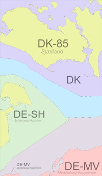
Maps and stats
| Name | Code | area type | Country | Geohash probability |
|---|---|---|---|---|
| ■ Sjælland | DK-85 | land | Denmark | 23.5% |
| ■ Mecklenburg-Vorpommern | DE-MV | land | Germany | 6.7% |
| ■ Schleswig-Holstein | DE-SH | land | Germany | 4.2% |
| ■ Denmark | DK | incl. waters | Denmark | 45.0% |
| ■ Mecklenburg-Vorpommern | DE-MV | incl. waters | Germany | 23.2% |
| ■ Schleswig-Holstein | DE-SH | incl. waters | Germany | 20.7% |
Local Geohashers
None, yet.
Expeditions
- 🇩🇪 2023-10-05 54 11 - Fippe visited Kellenhusen.
- 🇩🇰 2015-07-21 54 11 - Q-Owl & Q-Owla visited Lolland.
- 🇩🇪 2010-11-14 54 11 - mtu & his girlfriend visited Fehmarn.
mtu earned the Graticule Unlocked Achievement
|
