Difference between revisions of "South Waikato, New Zealand"
From Geohashing
imported>Greenslime m (map tag and claimed responsibility) |
m (removing map parameter since that is automatized now) |
||
| (8 intermediate revisions by 5 users not shown) | |||
| Line 1: | Line 1: | ||
| − | |||
| − | |||
| − | |||
{{QuickLinks|lat=-38|lon=175 | {{QuickLinks|lat=-38|lon=175 | ||
}} | }} | ||
{{graticule | {{graticule | ||
| − | |||
| lat= -38 | | lat= -38 | ||
| lon= 175 | | lon= 175 | ||
| Line 21: | Line 17: | ||
<!-- | <!-- | ||
'''Today's Location:''' | '''Today's Location:''' | ||
| − | [http:// | + | [http://carabiner.peeron.com/xkcd/map/map.html?date={{LOCALYEAR}}-{{LOCALMONTH}}-{{LOCALDAY2}}&lat=-38&long=175&zoom=9&abs=-1 South Waikato, NZ] |
| − | The '''South Waikato''' [[graticule]] is located at | + | The '''South Waikato''' [[graticule]] is located at {{Today's location|lat=-38|lon=175|text=latitude -38, longitude 175}}. |
--> | --> | ||
| Line 29: | Line 25: | ||
==Description== | ==Description== | ||
| + | The South Waikato region is the heartland of the North Island and the land supplies a large proportion of locally sold and exported primary produce (wood, beef and dairy). Land use is mostly farmland and forestry, but the region does have some notable attractions including the Hotpools at Tokaanu [http://www.nzhotpools.co.nz/hot-pools/tokaanu-thermal-pools], trout fishing at Turangi [http://www.turangi.co.nz/], the Kiwihouse at Otorohanga [http://www.kiwihouse.org.nz/], and of course New Zealands largest lake, Lake Taupo. | ||
==Links== | ==Links== | ||
| + | The South Waikato region even has a council website [http://www.southwaikato.govt.nz/]. | ||
==Statistics== | ==Statistics== | ||
| Line 41: | Line 39: | ||
}} | }} | ||
| − | {{ | + | {{Graticule unlocked |
| latitude = -38 | | latitude = -38 | ||
| longitude = 175 | | longitude = 175 | ||
| Line 50: | Line 48: | ||
==Local Geohashers== | ==Local Geohashers== | ||
| − | *[[user:Greenslime|Greenslime]] | + | an unknown quantity |
| + | |||
| + | ==Visitors== | ||
| + | *[[user:Greenslime|Greenslime]] | ||
*[[User:JimmyNZ|JimmyNZ]] | *[[User:JimmyNZ|JimmyNZ]] | ||
| Line 59: | Line 60: | ||
==Geohashes Not Reached== | ==Geohashes Not Reached== | ||
| − | == Photos == | + | == Photos Gallery== |
| − | |||
| − | |||
| − | |||
| − | |||
| − | |||
| − | |||
| − | |||
<gallery perrow="5"> | <gallery perrow="5"> | ||
| Line 74: | Line 68: | ||
[[Category:New Zealand]] | [[Category:New Zealand]] | ||
| − | [[Category: | + | [[Category:Inactive graticules]] |
| − | [[Category: | + | [[Category:Unlocked graticules]] |
| − | |||
| − | |||
| − | |||
| − | |||
| − | |||
Latest revision as of 18:54, 18 June 2024
|
Latest Coordinates and Map Quick-Links | |
|---|---|
| Saturday 2025-03-15 | -38.7656109, 175.3233616 |
| Sunday 2025-03-16 | -38.5401744, 175.5500346 |
| Monday 2025-03-17 | -38.3889059, 175.3997209 |
| Manukau City | Hamilton | Tauranga |
| Waitara | South Waikato | Rotorua |
| New Plymouth | Wanganui | Napier |
|
Today's location: geohashing.info google osm bing/os kml crox | ||

Contents
Description
The South Waikato region is the heartland of the North Island and the land supplies a large proportion of locally sold and exported primary produce (wood, beef and dairy). Land use is mostly farmland and forestry, but the region does have some notable attractions including the Hotpools at Tokaanu [1], trout fishing at Turangi [2], the Kiwihouse at Otorohanga [3], and of course New Zealands largest lake, Lake Taupo.
Links
The South Waikato region even has a council website [4].
Statistics
Greenslime and JimmyNZ earned the East geohash achievement
|
Greenslime and JimmyNZ earned the Graticule Unlocked Achievement
|
Local Geohashers
an unknown quantity
Visitors
Geohashes Reached
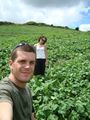
- 2010-01-29 - Greenslime and JimmyNZ - Farm Paddock, Near Lake Whakamaru, South Waikato
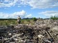
- 2010-02-01 - Greenslime and JimmyNZ - Farm Paddock, Near Arataki, South Waikato
Geohashes Not Reached
Photos Gallery
Sometimes reaching the hash is harder than it looks.
Farm Paddock, Near Arataki, South Waikato.

