Difference between revisions of "2009-02-13"
From Geohashing
imported>Thomcat (New page: <noinclude>{{date navigation}}</noinclude> {{auto coordinates}} {{auto gallery|2009-02-13}}) |
imported>ReletBot m (moving from Template:auto gallery to Template:auto gallery2) |
||
| (2 intermediate revisions by 2 users not shown) | |||
| Line 1: | Line 1: | ||
<noinclude>{{date navigation}}</noinclude> | <noinclude>{{date navigation}}</noinclude> | ||
| − | {{auto coordinates}} | + | {{auto coordinates|2009-02-13}} |
| − | {{auto | + | {{auto gallery2|2009-02-13}} |
| + | <noinclude>{{expedition summaries|2009-02-13}}</noinclude> | ||
Latest revision as of 22:25, 23 August 2010
Expedition Archives from February 2009
Thursday 12 February 2009 | Friday 13 February 2009 | Saturday 14 February 2009
See also: Category:Meetup on 2009-02-13
Coordinates
West of -30°: .7386951, .1201339
East of -30°: .4542140, .6897951
Globalhash:
-8.241476832986,68.326233704388
Photo Gallery

Expeditions and Plans
| 2009-02-13 | ||
|---|---|---|
| Atlanta, Georgia | Chris | These coordinates were less than a mile from Redan Park Disc Golf Course. I... |
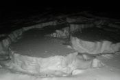
| Bonneville Salt Flats, Utah | Pardey | Pardey: This was an attempt both to reach the 2009-02-13 hashpoint f... |
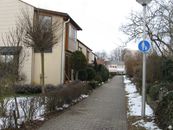
| Pforzheim, Germany | Ekorren | at Horb, on a footpath in the Hohenberg residential area. Hohenbe... |
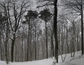
| Mannheim, Germany | ilpadre | was near the top of a mountain (at 325 m, with the top being at 327 m) near... |
| Kiruna, Sweden | the ru | was 20 km west of Skaulo, about 250 m from the Kaitum road. |