Difference between revisions of "2009-04-03 52 0"
imported>Benjw |
imported>FippeBot m (Location) |
||
| (5 intermediate revisions by one other user not shown) | |||
| Line 6: | Line 6: | ||
| graticule_link=Cambridge, United Kingdom | | graticule_link=Cambridge, United Kingdom | ||
}} | }} | ||
| − | + | == Location == | |
| + | On Hills Avenue, within Cambridge itself. A rare opportunity for a hash within the city. | ||
| − | + | == Participants == | |
| + | * [[User:Benjw|Benjw]] | ||
| + | |||
| + | == Expedition == | ||
| + | === 2009-04-03 === | ||
| + | The opportunity of a hash within my own city was too good to miss, so after getting home from work I cycled the 3.4km and was at the hashpoint at 4:30pm. | ||
| + | |||
| + | Of course, a hashpoint within a residential street leads to the problem of it being in someone's house or garden. Happily, today saw neither -- it was at the bottom of someone's fence on the side of the pavement. Photos were taken from all angles, and as I wasn't expecting anyone else to show up, I then left. | ||
| + | |||
| + | I cycled home via work, to see if I qualified for the cubicle geohash honourable mention. I didn't -- it was 1.04km, ''just'' too far to claim it. | ||
| + | |||
| + | === 2009-04-23 ([[User:Benjw|Benjw]]) === | ||
| + | |||
| + | Three weeks later, the [[2009-04-23 52 0]] hashpoint fell less than 2 km away from this spot, so I considered it worth a small detour on the way home to revisit it and take another photo. Not much had changed, except that spring had arrived and the plants had got a lot greener. This [[retro expedition]] was completed without using GPS, as I easily recognised the hashpoint from his previous visit. | ||
| + | |||
| + | == Photographic documentation == | ||
| + | <gallery> | ||
| + | Image:2009-04-03 52 0 hashpoint.jpg|Looking from across the street | ||
| + | Image:2009-04-03 52 0 hedge.jpg|The hashpoint and the pavement to the east. | ||
| + | Image:2009-04-03 52 0 west.jpg|Looking west along the road from the hashpoint. | ||
| + | Image:2009-04-03 52 0 gps.jpg|Proof that I made it there. | ||
| + | Image:2009-04-03 52 0 retro on 2009-04-23.jpg|Three weeks later, the trees and plants have got a lot greener! | ||
| + | </gallery> | ||
[[Category:Expeditions]] | [[Category:Expeditions]] | ||
[[Category:Expeditions with photos]] | [[Category:Expeditions with photos]] | ||
[[Category:Coordinates reached]] | [[Category:Coordinates reached]] | ||
| − | + | {{location|GB|ENG|CAM}} | |
| − | |||
Latest revision as of 02:36, 8 August 2019
| Fri 3 Apr 2009 in Cambridge: 52.1842062, 0.1462521 geohashing.info google osm bing/os kml crox |
Contents
Location
On Hills Avenue, within Cambridge itself. A rare opportunity for a hash within the city.
Participants
Expedition
2009-04-03
The opportunity of a hash within my own city was too good to miss, so after getting home from work I cycled the 3.4km and was at the hashpoint at 4:30pm.
Of course, a hashpoint within a residential street leads to the problem of it being in someone's house or garden. Happily, today saw neither -- it was at the bottom of someone's fence on the side of the pavement. Photos were taken from all angles, and as I wasn't expecting anyone else to show up, I then left.
I cycled home via work, to see if I qualified for the cubicle geohash honourable mention. I didn't -- it was 1.04km, just too far to claim it.
2009-04-23 (Benjw)
Three weeks later, the 2009-04-23 52 0 hashpoint fell less than 2 km away from this spot, so I considered it worth a small detour on the way home to revisit it and take another photo. Not much had changed, except that spring had arrived and the plants had got a lot greener. This retro expedition was completed without using GPS, as I easily recognised the hashpoint from his previous visit.
Photographic documentation
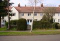
Looking from across the street
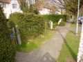
The hashpoint and the pavement to the east.
- Error creating thumbnail: Unable to save thumbnail to destination
Looking west along the road from the hashpoint.
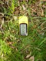
Proof that I made it there.
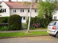
Three weeks later, the trees and plants have got a lot greener!


