Difference between revisions of "2009-04-25 48 -123"
m |
|||
| (5 intermediate revisions by 4 users not shown) | |||
| Line 24: | Line 24: | ||
(in order of arrival) | (in order of arrival) | ||
*[[user:thepiguy|thepiguy]] and Jafo showed up around noon | *[[user:thepiguy|thepiguy]] and Jafo showed up around noon | ||
| − | *[[ | + | *[[User:Dino and Cooki|Dino and Cooki]] made it to their first geohash at 4:00 |
*[[user:elbie|elbie]] was there just after 5:00 | *[[user:elbie|elbie]] was there just after 5:00 | ||
| Line 70: | Line 70: | ||
They didn't spend much time at the coordinates since they were on a tight schedule. thepiguy took a few pictures with the golf ball he brought, got asked by one of the owners to try and help fix his phone, and forgot to leave a chalk mark. | They didn't spend much time at the coordinates since they were on a tight schedule. thepiguy took a few pictures with the golf ball he brought, got asked by one of the owners to try and help fix his phone, and forgot to leave a chalk mark. | ||
| − | Also, thepiguy didn't want to dive | + | Also, thepiguy didn't want to dive too quickly into geohashing with Jafo. That way she'll be more receptive the <i>[[Roma, Italy|next time]]</i> he drags her off into the middle of nowhere. |
==Photos== | ==Photos== | ||
| Line 116: | Line 116: | ||
[[Category:Coordinates reached]] | [[Category:Coordinates reached]] | ||
[[Category:Elbie]] | [[Category:Elbie]] | ||
| + | {{location|CA|BC|CP}} | ||
Latest revision as of 13:26, 3 November 2021
| Sat 25 Apr 2009 in 48,-123: 48.4809778, -123.3527699 geohashing.info google osm bing/os kml crox |
Contents
Location
At the Mt. Douglas Golf Course in Saanich (near Victoria).
Planning
Elbie is planning to do this one. Her current plan:
- 8:00 - 10:00 -- help a friend move. Hopefully will be done by 10.
- 10:00ish -- bike to Airport Station in Richmond, take the bus to Tsawwassen.
- 13:00 -- get on the ferry to Swartz Bay
- 14:30ish -- get on the Lochside trail, bike to coordinates. Should arrive around 16:00-16:30.
Note to self for getting home: ferries depart Swartz Bay at 15:00, 17:00 and 21:00. Must get back to Swartz Bay by 20:30!!!
Oh noes! Looks like we're splitting the graticule. Has this ever happened before? Wade and Robyn are planning 2009-04-25 49 -123! Yours is a slightly cheaper ferry ride, and it's on a golf course. Decisions! -Robyn 01:48, 25 April 2009 (UTC)
Dino and Cooki also planned to do this one as their first Geohash hours before they left for their previously planned Victoria trip since it was convenient!
Participants
(in order of arrival)
- thepiguy and Jafo showed up around noon
- Dino and Cooki made it to their first geohash at 4:00
- elbie was there just after 5:00
Elbie's Expedition
Getting to the Island
Elbie and her bike Jadzia wound up leaving UBC around 10, and had a smooth bike ride down to Richmond (except for one near-collision with a car on SW Marine, and feeling terrified crossing the Arthur Laing Bridge, but that seems like as smooth as it gets). Getting to Airport Station from the bridge turned out to be tricky. There was a nice sign for cyclists indicating one should turn off there to go to "Richmond and Airport Station", so naturally she turned off there. The turn-off then forked, one way to "Airport" and one way to "Richmond." Confused by the latter sign's wording, the former was taken, which led to a shoulder of an exit of a highway that initially looked like it clover-leafed over to Airport Station. But no, after ridden on it for a minute, it was discovered it went, instead, to the Airport.
Elbie backtracked, and then took the route to "Richmond", soon arriving at Airport Station, well in advance to take the 620. She wound up talking to a nice lady there who, shockingly enough, had heard of geohashing! The lady mentioned her husband had done it. Elbie wishes she'd gotten the lady's name. The 620 arrived on time, and soon Elbie was at Tsawwassen, just in time to take the nonexistent 12:00 ferry to Swartz Bay.
Getting to the Hashpoint
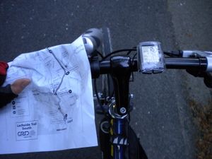
As the 13:00 ferry didn't arrive in Swartz Bay until around 15:00, Elbie quickly hit the Lochside Trail, along the way consuming copious amounts of chicken broth and granola bars. The Lochside has markers every kilometer along the trail, with the 34km marker at Swartz Bay, and the 1 km marker in Victoria. By the maps she had printed out the night before and consulted well, she continued on the trail until the 10 km marker, and then took the first left onto a little rural road, eventually turning right onto Blenkinsop Rd, a little highway. She rode on the shoulder until she got to the first golf course, and turned off.
She had correctly remembered that the hashpoint was on a golf course on Blenkinsop Rd, but it turns out there were three such courses in that area. After getting directions to the Mt Douglas Golf Course, she promptly headed over, consulting her map printouts as she went. Upon arriving, she quickly found the hashpoint was right beside the rental office for the course.
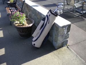
Going in, she rented some clubs and a ball, and quickly nabbed the Golf Geohash Achievement. Then, deciding she should get her money's worth out of the clubs, she made a valiant and hilariously clueless attempt at real golf. The receptionist wound up coming out and politely asking her, "do you know anything about golf?" To which she could only answer, "No."
Elbie had come to an advanced golf course, wearing riding boots that had a 1-cm heel. She was then informed those are not appropriate golfing shoes, and that they would leave marks on the green. The receptionist kindly gave her a refund for the club rental, and Elbie quickly and embarrassedly left. She wonders what the receptionist would have thought of the hastily-made chalk markings left behind beside the office.
Getting Home
From there, Elbie got back on the Lochside Trail, stopping once at one of the parks on the trail (yay! Swings!), and biked back to Swartz Bay just in time to see the 19:00 ferry leave. She had another long wait, taking the 21:00 ferry (which was delayed by half an hour). Only one other cyclist turned up at the terminal. The two exchanged relief that they wouldn't have to fight for the bike racks on the 620.
Elbie and the other cyclist arrived in Tsawwassen around 23:00, and quickly nabbed the bike rack on the 620. At Airport Station, the other cyclist gave her directions on how to get onto the Arthur Laing, and after a snack, she was off. As it turns out, the bridge is extremely terrifying around 23:45. Not reading signs properly as she was trying not to get run over, she got confused and took the turn-off to Granville. This involved a completely frightening merge with vehicles going horrifyingly fast.
Once on Granville, Elbie realised her mistake, and got onto SW Marine. Pumped full of epinephrine from the Arthur Laing Experience, it was a pretty quick ride back to the University Endowment Lands, followed by a slow ride home from there once her parasympathetic nervous system had reasserted itself. Home at half past midnight having biked over 91 km, she stumbled into her apartment and fell asleep.
Dino and Cooki's Expedition
This was a really easy expedition for first-timers Dino and Cooki because they were already on the island! They had arrived the night before and were planning to spend the weekend visiting Victoria. They also already had the car so it was just a matter of driving there in between their shopping and sight-seeing.
Unfortunately, their GPS Navigation system did not function while they were in Victoria so they had to use a primitive map to navigate. It was really an old map since it has been in Dino's car since the early 90s. They drove from the Strathcona Hotel in Downtown Victoria to the golf course, a short, easy and amusing trip. Dino was especially amused by the carpet company named "Fuzzy Wuzzy". They arrived shortly after 4PM.
Without a navigational system to pinpoint the exact location of the geohash on the golf course, Dino and Cooki settled for photos with the sign. While taking photos, someone(s) in a vehicle drove by and yelled "GEEKS!" at Dino and Cooki. This was amusing since if they knew what Dino and Cooki were doing, the drive-by yellers would also be fellow geeks!
Being newbies, Dino and Cooki failed to provide evidence of the date! :(
thepiguy
thepiguy and his friend Jafo had already made plans to bike to Victoria that Saturday, so when the location ended practically on the bike path, a detour was in order.
They didn't spend much time at the coordinates since they were on a tight schedule. thepiguy took a few pictures with the golf ball he brought, got asked by one of the owners to try and help fix his phone, and forgot to leave a chalk mark.
Also, thepiguy didn't want to dive too quickly into geohashing with Jafo. That way she'll be more receptive the next time he drags her off into the middle of nowhere.
Photos
Elbie
Dino and Cooki
thepiguy
Achievements
Elbie
Elbie earned the Bicycle geohash achievement
|
Elbie earned the No Batteries Geohash Achievement
|
Elbie earned the Golf Geohash Achievement
|


