Difference between revisions of "2010-01-24 -36 174"
(→Location) |
imported>FippeBot m (Location) |
||
| (16 intermediate revisions by 4 users not shown) | |||
| Line 14: | Line 14: | ||
__NOTOC__ | __NOTOC__ | ||
== Location == | == Location == | ||
| − | + | A paddock in the middle of whop whops, near a small town named Taupaki, West Auckland. | |
== Participants == | == Participants == | ||
| + | * [[User:Greenslime|Greenslime]] | ||
| + | * [[User:JimmyNZ|JimmyNZ]] | ||
| + | == Plans == | ||
| + | Procured a GPS, a set of wheels and a camera plus screen shots of the hash and proceeded the approx 14 kms to the hashpoint. | ||
| − | == | + | == Expedition == |
| + | After a nice lunch of sushi, we ambled along the scenic country roads of West Auckland, encouraged along by the occasional beeps from the newly acquired GPS. After the navigator started calling out the left/rights before we hit the intersections we managed to locate 'Peters Lane' and were confronted by a big bold 'Private Property - No entry' sign. | ||
| + | After pausing to consider our options we decided that if confronted by some angry cockie one of us would explain the gist of the game (I'm sure he would have accepted this.) while the other fled for their life. Fortunately we were only confronted by a strange dutch grandma with small child and dog in tow. A brief education of the game, where the GPS co-ordinate was and what paddock we need to access was discussed. Gratefully, we are expert negotiators and managed to gain entry. Strange though, she did ask if there would be others, to which we both reply 'strongly doubt it!' | ||
| + | So after checking for the standard bulls, barbwire, electric fences and cow pies we then bolted the fence and spent the next ten minutes walking around in a haphazard manner trying to skillfully align every last digit on our stolen (Did I say stolen? I meant borrowed.) GPS. Finally the digits locked in and the collation of documentation commenced. | ||
| − | + | Then we high tailed it before the cockie showed up. | |
| + | Oh this is Greenslime's virgin hash and we also noted it has been a long time since anyone in the [[Auckland, New Zealand|Auckland]] graticule has reached a hash point. You can swim can't you? | ||
== Tracklog == | == Tracklog == | ||
| Line 30: | Line 38: | ||
== Photos == | == Photos == | ||
| − | < | + | <gallery> |
| − | + | File:2010 01 24 -36 174 view from the hashs.jpg | View from the farmers paddock, can you see the bull? | |
| − | + | File:2010 01 24 -36 174 Private propertys.jpg | Disregarded | |
| − | + | File:2010 01 24 -36 174 Peters Lanes.jpg | Peter live here? We didn't meet him. | |
| + | File:2010 01 24 -36 174 JimmyNZs.jpg | JimmyNZ at the hashpoint | ||
| + | File:2010 01 24 -36 174 GPS coordinates.jpg | The required proof, where's our pudding? | ||
</gallery> | </gallery> | ||
| − | |||
| + | ==Hash Awards== | ||
| + | |||
| + | {{land geohash | ||
| + | | latitude = -36 | ||
| + | | longitude = 174 | ||
| + | | date = 2010-01-24 | ||
| + | | name = Greenslime | ||
| + | | image = 2010_01_24_-36_174_view from the hashs.jpg | ||
| + | }} | ||
| + | |||
| + | {{A Tale of Two Hashes | ||
| + | | latitude = -36 | ||
| + | | longitude = 174 | ||
| + | | date = 2010-01-24 | ||
| + | | user2 = Hessophanes, Hiro, JUB and relet | ||
| + | | name = Greenslime | ||
| + | | place = New Zealand | ||
| + | | image = 2010 01 24 -36 174 view from the hashs.jpg | ||
| + | }} | ||
| − | |||
| − | |||
| − | |||
| − | |||
| − | |||
| − | |||
| − | |||
[[Category:Expeditions]] | [[Category:Expeditions]] | ||
| − | |||
[[Category:Expeditions with photos]] | [[Category:Expeditions with photos]] | ||
| − | |||
| − | |||
| − | |||
| − | |||
| − | |||
[[Category:Coordinates reached]] | [[Category:Coordinates reached]] | ||
| − | + | {{location|NZ|AUK}} | |
| − | |||
| − | |||
| − | |||
| − | |||
| − | |||
| − | |||
| − | |||
| − | |||
| − | |||
Latest revision as of 00:36, 9 August 2019
| Sun 24 Jan 2010 in -36,174: -36.8191506, 174.5349633 geohashing.info google osm bing/os kml crox |
Location
A paddock in the middle of whop whops, near a small town named Taupaki, West Auckland.
Participants
Plans
Procured a GPS, a set of wheels and a camera plus screen shots of the hash and proceeded the approx 14 kms to the hashpoint.
Expedition
After a nice lunch of sushi, we ambled along the scenic country roads of West Auckland, encouraged along by the occasional beeps from the newly acquired GPS. After the navigator started calling out the left/rights before we hit the intersections we managed to locate 'Peters Lane' and were confronted by a big bold 'Private Property - No entry' sign. After pausing to consider our options we decided that if confronted by some angry cockie one of us would explain the gist of the game (I'm sure he would have accepted this.) while the other fled for their life. Fortunately we were only confronted by a strange dutch grandma with small child and dog in tow. A brief education of the game, where the GPS co-ordinate was and what paddock we need to access was discussed. Gratefully, we are expert negotiators and managed to gain entry. Strange though, she did ask if there would be others, to which we both reply 'strongly doubt it!'
So after checking for the standard bulls, barbwire, electric fences and cow pies we then bolted the fence and spent the next ten minutes walking around in a haphazard manner trying to skillfully align every last digit on our stolen (Did I say stolen? I meant borrowed.) GPS. Finally the digits locked in and the collation of documentation commenced.
Then we high tailed it before the cockie showed up.
Oh this is Greenslime's virgin hash and we also noted it has been a long time since anyone in the Auckland graticule has reached a hash point. You can swim can't you?
Tracklog
Photos
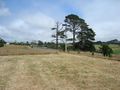
View from the farmers paddock, can you see the bull?
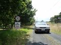
Disregarded
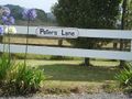
Peter live here? We didn't meet him.
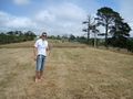
JimmyNZ at the hashpoint
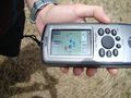
The required proof, where's our pudding?


Hash Awards
Greenslime earned the Land geohash achievement
|
