Difference between revisions of "2010-04-13 45 -122"
From Geohashing
imported>Aperfectring (a live expedition message sent via geohashdroid for android.) |
imported>FippeBot m (Location) |
||
| (8 intermediate revisions by 2 users not shown) | |||
| Line 17: | Line 17: | ||
== Participants == | == Participants == | ||
| − | * [[User:Jiml|Jim]] | + | * [[User:Jiml|Jim]] - Was picked up by Aperfectring on the way. |
| − | * [[User:Aperfectring|Aperfectring]] | + | * [[User:Aperfectring|Aperfectring]] - Picked up Jim on the way. |
== Plans == | == Plans == | ||
| Line 26: | Line 26: | ||
<!-- how it all turned out. your narrative goes here. --> | <!-- how it all turned out. your narrative goes here. --> | ||
| − | + | *Approaching hashpoint on foot. -- [[User:Aperfectring|aperfectring]] [http://www.openstreetmap.org/?lat=45.500694083333336&lon=-122.90827973333333&zoom=16&layers=B000FTF @45.5007,-122.9083] 20:40, 13 April 2010 (UTC) | |
| − | * | + | *Expedition success. Speed racer achieved. -- [[User:Aperfectring|aperfectring]] [http://www.openstreetmap.org/?lat=45.50061945&lon=-122.90725661666667&zoom=16&layers=B000FTF @45.5006,-122.9073] 20:40, 13 April 2010 (UTC) |
| + | |||
| + | ==Photos== | ||
| + | <gallery> | ||
| + | Image:2010-04-13_45_-122-scenery.jpg | Scenery around the hashpoint | ||
| + | Image:2010-04-13_45_-122-hashpoint.jpg | Picture of the hashpoint :-) | ||
| − | |||
| − | |||
| − | |||
| − | |||
| − | |||
Image:2010-04-13_45_-122_12-36-42-320.jpg | Traffic @ the hash preventing good gps picture [http://www.openstreetmap.org/?lat=45.5002976&lon=-122.90726091666667&zoom=16&layers=B000FTF @45.5003,-122.9073] | Image:2010-04-13_45_-122_12-36-42-320.jpg | Traffic @ the hash preventing good gps picture [http://www.openstreetmap.org/?lat=45.5002976&lon=-122.90726091666667&zoom=16&layers=B000FTF @45.5003,-122.9073] | ||
| + | Image:2010-04-13_45_-122-gps.jpg | Proof of the hashpoint | ||
| + | Image:2010-04-13_45_-122_13-15-26-063.jpg | Jiml dodging traffic @ the hashpoint. [http://www.openstreetmap.org/?lat=45.49680871666666&lon=-122.88667558333333&zoom=16&layers=B000FTF @45.4968,-122.8867] | ||
| + | Image:2010-04-13_45_-122-apr.jpg | APR at the hashpoint | ||
| + | |||
</gallery> | </gallery> | ||
| − | |||
| − | + | ||
| − | + | {{land_geohash | |
| + | | latitude = 45 | ||
| + | | longitude = -122 | ||
| + | | date = 2010-04-13 | ||
| + | | name = [[User:aperfectring|APR]] and [[User:Jiml|Jim]] | ||
| + | }} | ||
| + | |||
| + | {{cubicle geohash | ||
| + | | latitude = 45 | ||
| + | | longitude = -122 | ||
| + | | date = 2010-04-13 | ||
| + | | name = [[User:Jiml|Jim]] | ||
| + | | honor = almost | ||
| + | }} | ||
| + | |||
| + | [[Category:Expeditions]] | ||
| + | [[Category:Expeditions with photos]] | ||
| + | |||
| + | |||
[[Category:Coordinates reached]] | [[Category:Coordinates reached]] | ||
| − | + | {{location|US|OR|WI}} | |
| − | |||
| − | |||
| − | |||
| − | |||
| − | |||
| − | |||
| − | |||
| − | |||
| − | |||
Latest revision as of 01:36, 9 August 2019
| Tue 13 Apr 2010 in 45,-122: 45.5007359, -122.9087812 geohashing.info google osm bing/os kml crox |
Location
The 22500 block of SW Johnson, close to Century High School. It appears to be in the street.
Participants
- Jim - Was picked up by Aperfectring on the way.
- Aperfectring - Picked up Jim on the way.
Plans
Program a GPS, go, and take pictures.
Expedition
- Approaching hashpoint on foot. -- aperfectring @45.5007,-122.9083 20:40, 13 April 2010 (UTC)
- Expedition success. Speed racer achieved. -- aperfectring @45.5006,-122.9073 20:40, 13 April 2010 (UTC)
Photos
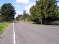
Scenery around the hashpoint

Picture of the hashpoint :-)
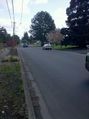
Traffic @ the hash preventing good gps picture @45.5003,-122.9073
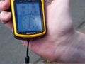
Proof of the hashpoint

Jiml dodging traffic @ the hashpoint. @45.4968,-122.8867

APR at the hashpoint


APR and Jim earned the Land geohash achievement
|
Jim earned the cubicle geohash almost honorable mention
|