Difference between revisions of "2010-08-13 66 25"
imported>Isopekka (→Tutkimusretki) |
imported>FippeBot m (Location) |
||
| (5 intermediate revisions by 2 users not shown) | |||
| Line 1: | Line 1: | ||
| − | + | [[Image:Geohäsläys2 008.JPG|thumb|left]] | |
| − | |||
| − | [[Image: | ||
| − | |||
| − | |||
| − | |||
| − | |||
| − | |||
| − | |||
{{meetup graticule | {{meetup graticule | ||
| lat=66 | | lat=66 | ||
| Line 14: | Line 6: | ||
}} | }} | ||
| − | |||
== Location == | == Location == | ||
Rovaniemi, Finland. 27 km from the city of Rovaniemi, Finland. | Rovaniemi, Finland. 27 km from the city of Rovaniemi, Finland. | ||
Vain 27 km teitä pitkin pisteelle, ja autolla lähes viereen. Tänne on mentävä! | Vain 27 km teitä pitkin pisteelle, ja autolla lähes viereen. Tänne on mentävä! | ||
| + | |||
== Osallistujat == | == Osallistujat == | ||
| − | |||
* [[User:isopekka|isopekka]] | * [[User:isopekka|isopekka]] | ||
| + | |||
== Tutkimusretki == | == Tutkimusretki == | ||
| Line 30: | Line 22: | ||
* Retken kesto 1.5 h | * Retken kesto 1.5 h | ||
* Fyysinen rasittavuus (1-5): 1 | * Fyysinen rasittavuus (1-5): 1 | ||
| + | |||
==Valokuvia == | ==Valokuvia == | ||
| Line 43: | Line 36: | ||
Image:Geohäsläys2 003.JPG| View to the West from zero point | Image:Geohäsläys2 003.JPG| View to the West from zero point | ||
Image:Geohäsläys2 008.JPG| The Ternu river about 180 m from the ground zero | Image:Geohäsläys2 008.JPG| The Ternu river about 180 m from the ground zero | ||
| + | </Gallery> | ||
| + | |||
| + | |||
| + | ==Achievements== | ||
| + | |||
| + | {{land geohash | ||
| + | |||
| + | | latitude = 66 | ||
| + | | longitude = 25 | ||
| + | | date = 2010-08-13 | ||
| + | | name = isopekka | ||
| + | |||
| + | }} | ||
| + | |||
| + | |||
| + | == Other Geohashing Expeditions and Plans on This Day == | ||
| + | |||
| + | {{expedition summaries|2010-08-13}} | ||
| + | |||
| − | |||
| Line 51: | Line 62: | ||
[http://translate.google.com/translate?hl=en&sl=auto&tl=en&u=http%3A%2F%2Fwiki.xkcd.com%2Fgeohashing%2F2010-08-13_66_25] | [http://translate.google.com/translate?hl=en&sl=auto&tl=en&u=http%3A%2F%2Fwiki.xkcd.com%2Fgeohashing%2F2010-08-13_66_25] | ||
| − | |||
| − | |||
[[Category:Expeditions]] | [[Category:Expeditions]] | ||
| − | |||
[[Category:Expeditions with photos]] | [[Category:Expeditions with photos]] | ||
| − | |||
[[Category:Coordinates reached]] | [[Category:Coordinates reached]] | ||
| + | [[Category:Pages in Finnish]] | ||
| + | {{location|FI|10}} | ||
Latest revision as of 03:17, 9 August 2019

| Fri 13 Aug 2010 in 66,25: 66.4590373, 25.3103065 geohashing.info google osm bing/os kml crox |
Contents
Location
Rovaniemi, Finland. 27 km from the city of Rovaniemi, Finland. Vain 27 km teitä pitkin pisteelle, ja autolla lähes viereen. Tänne on mentävä!
Osallistujat
Tutkimusretki
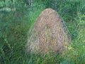
Kun perjantain pakolliset hommat kauppareissuineen tuli tehtyä, niin oitis kohti nollapistettä. Ensin suuntana Muurola, sitten metsäoppilaitoksen kohdalta vielä 7 km Ahmakuusikontietä pohjoiseen ja kas, nopeasti olin nollapisteen lähellä. Suuria rämpimisiä ei tarvittu, pienen pellon yli ja kolmisenkymmentä metriä suota pitkin. Kello 18.58 olin perillä. Nollapiste löytyi siis helposti, vaikka tänään olikin perjantai ja 13. päivä. Hillan lehtiä ympärillä, mutta ei ainuttakaan hillaa...
- Autolla yhteensä 72 km
- Kävelyä yhteensä n. 300 m
- Retken kesto 1.5 h
- Fyysinen rasittavuus (1-5): 1
Valokuvia
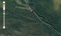
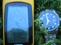
Satellite picture of the hashpoint
160 m to the ground zero
130 m to the ground zero
30 m to the ground zero
5 m to the ground zero
3 m to the ground zero
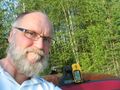
Ground Zero Point
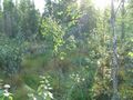
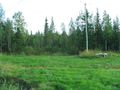
View to the West from zero point
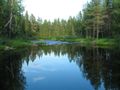
The Ternu river about 180 m from the ground zero


Achievements
isopekka earned the Land geohash achievement
|
Other Geohashing Expeditions and Plans on This Day
Expeditions and Plans
| 2010-08-13 | ||
|---|---|---|
| Jackson, Tennessee | Josh | About 7 miles south of Jackson, TN, at 35.576297°, -88.834° |
| Cleveland, Ohio | jSchleappi, friend | In the lake. Again. |
| Klamath Falls, Oregon | Michael5000, Mrs.5000 | In National Forest Land east of Chiloquin, Oregon. |
| Wausau, Wisconsin | Bassoon, Dedehawk, Kuderererer | The side of a road (Lone Elm Road) in or around Wisconsin Rapids. Or Wausa... |
| Cambridge, United Kingdom | Benjw | At the edge of a cornfield in Littleport, just behind some houses. |
| Norwich, United Kingdom | Sourcerer | In a Norfolk wheat field near Alburgh west of Bungay, Suffolk, United Kingd... |
| Berlin, Germany | User:lyx | Schmidt-Ott-Straße in Berlin-Dahlem |
| Visby, Sweden | Floffe | The hash was at a newly mowed hay field in Mästerby. On the way there, Floffe... |
| Rovaniemi, Finland | isopekka | Rovaniemi, Finland. 27 km from the city of Rovaniemi, Finland. Vain 27 km t... |
Translation to English
Google Translate link for this page: