Difference between revisions of "2010-09-11 -36 174"
imported>Greenslime m (Created page with '{{subst:Expedition |lat = -36 |lon = 174 |date = 2010-09-11 }}') |
imported>FippeBot m (Location) |
||
| (7 intermediate revisions by 2 users not shown) | |||
| Line 1: | Line 1: | ||
| − | |||
| − | |||
| − | |||
| − | |||
| − | |||
| − | |||
| − | |||
| − | |||
| − | |||
| − | |||
{{meetup graticule | {{meetup graticule | ||
| lat=-36 | | lat=-36 | ||
| Line 15: | Line 5: | ||
}} | }} | ||
| − | |||
__NOTOC__ | __NOTOC__ | ||
== Location == | == Location == | ||
| − | + | In the bush of the Waitakere Ranges, west of Auckland. The hash point lay about 100m south of a river, off a track, off Anawhata Road. Totally accessible if you are in an adventurous frame of mind. | |
== Participants == | == Participants == | ||
| − | + | *[[User:JimmyNZ|JimmyNZ]] | |
| + | *[[User:Greenslime|Greenslime]] | ||
== Plans == | == Plans == | ||
| − | + | Drive there, don wet weather kit plus emergency supplies, and amble on in to the bush. | |
== Expedition == | == Expedition == | ||
| − | + | After awaking way too early for a Saturday morning, with coffee in hand, the hash was checked. It was only 23 km from our location in the bush in the Waitakere Ranges. Jimmy and I had been awaiting another bush bashing opportunity, Jimmy in particular, after the shame of failure on a previous [[2010-06-19 -36 174|attempt]]. After downloading the appropriate topo map, we discovered there was a track that lead down to a particular river (stream) that we could then navigate up. About 100 m south of a point on the stream lay the hash. Sounded very achievable with a fully functional GPS, which we had managed to acquire. | |
| + | We set off on yet another rainy Auckland day (it is winter still, not that that matters in Auckland). After missing the signage for the track we doubled back, and parked up. The path to the river was steep with clay, although there were stairs. The amble up river was even more challenging with supple-jack crossing our path in every direction. At some point we decided we better check the GPS for our proximity to the river exit point. | ||
| + | |||
| + | What's even more annoying than supple-jack and spider-webs, is a GPS that A)does not register your location, and B)tells you that you need to travel 300 m in the exact opposite direction to which you know you are supposed to be traveling. We cut our losses very early on this one realising that the bush cover and the overcast conditions were not conducive to us finding an exact GPS coordinate. So we walked down stream, and I managed to almost fully submerge myself only 5 m before the stream exit, nice going, and I had managed to retain dry socks up till that point. | ||
| + | |||
| + | Overall, a little disappointing with the technology failure, but still much fun was had bush bashing on a mild, rainy day, in the middle of paradise. | ||
| + | |||
| + | <!-- Nothing in this section for now> | ||
== Tracklog == | == Tracklog == | ||
<!-- if your GPS device keeps a log, you may post a link here --> | <!-- if your GPS device keeps a log, you may post a link here --> | ||
== Photos == | == Photos == | ||
| − | + | Photos to come. | |
| − | |||
| − | |||
<gallery perrow="5"> | <gallery perrow="5"> | ||
| + | File:2010-09-11 -36 174 Drowned Rat.jpg|Drowned rat of the JimmyNZ variety | ||
| + | File:2010-09-11 -36 174 Quagmire Supplejack.jpg|One of the nicer sections where there was room to take a photo | ||
| + | File:2010-09-11_-36_174_Where_to_now.jpg|GPS fail, JimmyNZ considering its aerodynamic potential during flight | ||
</gallery> | </gallery> | ||
| + | <!-- Nothing in this section for now - I don't think there are any ribbons for this expedition,really.> | ||
== Achievements == | == Achievements == | ||
{{#vardefine:ribbonwidth|800px}} | {{#vardefine:ribbonwidth|800px}} | ||
<!-- Add any achievement ribbons you earned below, or remove this section --> | <!-- Add any achievement ribbons you earned below, or remove this section --> | ||
| − | + | [[Category:Expeditions with photos]] | |
| − | |||
| − | |||
| − | [[Category: | ||
| − | |||
| − | |||
| − | |||
| − | |||
| − | |||
| − | |||
| − | |||
[[Category:Expeditions]] | [[Category:Expeditions]] | ||
| − | |||
| − | |||
| − | |||
| − | |||
| − | |||
| − | |||
| − | |||
| − | |||
| − | |||
| − | |||
| − | |||
[[Category:Coordinates not reached]] | [[Category:Coordinates not reached]] | ||
| − | |||
| − | |||
| − | |||
[[Category:Not reached - Technology]] | [[Category:Not reached - Technology]] | ||
| − | + | {{location|NZ|AUK}} | |
| − | |||
Latest revision as of 03:40, 9 August 2019
| Sat 11 Sep 2010 in -36,174: -36.9314646, 174.4966417 geohashing.info google osm bing/os kml crox |
Location
In the bush of the Waitakere Ranges, west of Auckland. The hash point lay about 100m south of a river, off a track, off Anawhata Road. Totally accessible if you are in an adventurous frame of mind.
Participants
Plans
Drive there, don wet weather kit plus emergency supplies, and amble on in to the bush.
Expedition
After awaking way too early for a Saturday morning, with coffee in hand, the hash was checked. It was only 23 km from our location in the bush in the Waitakere Ranges. Jimmy and I had been awaiting another bush bashing opportunity, Jimmy in particular, after the shame of failure on a previous attempt. After downloading the appropriate topo map, we discovered there was a track that lead down to a particular river (stream) that we could then navigate up. About 100 m south of a point on the stream lay the hash. Sounded very achievable with a fully functional GPS, which we had managed to acquire.
We set off on yet another rainy Auckland day (it is winter still, not that that matters in Auckland). After missing the signage for the track we doubled back, and parked up. The path to the river was steep with clay, although there were stairs. The amble up river was even more challenging with supple-jack crossing our path in every direction. At some point we decided we better check the GPS for our proximity to the river exit point.
What's even more annoying than supple-jack and spider-webs, is a GPS that A)does not register your location, and B)tells you that you need to travel 300 m in the exact opposite direction to which you know you are supposed to be traveling. We cut our losses very early on this one realising that the bush cover and the overcast conditions were not conducive to us finding an exact GPS coordinate. So we walked down stream, and I managed to almost fully submerge myself only 5 m before the stream exit, nice going, and I had managed to retain dry socks up till that point.
Overall, a little disappointing with the technology failure, but still much fun was had bush bashing on a mild, rainy day, in the middle of paradise.
Photos
Photos to come.
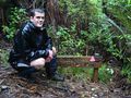
Drowned rat of the JimmyNZ variety
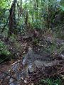
One of the nicer sections where there was room to take a photo
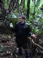
GPS fail, JimmyNZ considering its aerodynamic potential during flight


