Difference between revisions of "2010-11-14 52 13"
imported>Plypkie (Created page with '{{subst:Expedition |lat = 52 |lon = 13 |date = 2010-11-14 }}') |
imported>FippeBot m (Location) |
||
| (19 intermediate revisions by 5 users not shown) | |||
| Line 1: | Line 1: | ||
| − | |||
| − | |||
| − | |||
| − | |||
| − | |||
| − | |||
| − | |||
| − | |||
| − | |||
| − | |||
{{meetup graticule | {{meetup graticule | ||
| lat=52 | | lat=52 | ||
| Line 15: | Line 5: | ||
}} | }} | ||
| − | + | ||
__NOTOC__ | __NOTOC__ | ||
== Location == | == Location == | ||
| − | + | 2.5km southwest of Seeburg, which in turn is southwest of Spandau. | |
| + | |||
| + | {{PBGH battleship|lat=52|lon=13|date=2010-11-14}} | ||
== Participants == | == Participants == | ||
| − | + | *[[User:Plypkie|plypkie]] is planning to ride his bike. | |
| + | *[[User:lyx|lyx]], [[User:relet|relet]] and [[User:amuzulo|amuzulo]] are planning to take a bus from Spandau, which should pass along the road ca. 16:05. Return ca. 17:00, hence games will be provided. | ||
== Plans == | == Plans == | ||
| − | + | Afternoon forecast calls for 70% chance of rain, although just "light rain showers", less than 0.1mm. Temperature is supposed to climb to 16C or 17C. Should be a decent day. | |
| + | |||
| + | plypkie plans to leave home by bike at around 2pm, and be at the hash point near 4pm. All plans are adjustable if someone else wants to meet at a different time. | ||
== Expedition == | == Expedition == | ||
| − | + | Success! | |
| + | |||
| + | === Team Bicycle === | ||
| + | |||
| + | The lone member of Team Bicycle, [[User:Plypkie|plypkie]], got on his bike at about quarter to 2, and started off down the road. He went through the middle of town past the Reichstag and Strasse der 17. Juni, and kept on riding seemingly forever...although it wasn't actually forever, it was only about an hour to reach Spandau. There's actually a pretty nice bike route to Spandau that stays slightly off the main road, which was nice. | ||
| + | |||
| + | After Spandau, his GPS led him down a little tiny road through the forest, and then he popped out in Seeburg...and while not paying attention, almost missed it. Seeburg is tiny. He waited around for Team Bus to catch up, which took about 20 minutes, meeting them at about 4:15 as the sun was setting. | ||
| + | |||
| + | === Team Bus === | ||
| + | |||
| + | |||
| + | === Together at last === | ||
| + | |||
| + | We walked down the road, almost getting run down by a foul-mouthed Superhero (a cyclist dressed in brightly-colored Spandex). Eventually finding a dirt trail, we followed that through the forest, finding some people who were apparently having some sort of sunset picnic. The weather was still unusually warm, allowing tshirts to be worn while walking. | ||
| + | |||
| + | The hash point was in the middle of an empty field bordered by trees. The sun had already gone down, and plypkie spotted some sort of owl flying over the tree-tops. Some juggling ensued, and some vegan cookies were eaten. | ||
| + | |||
| + | Eventually, plypkie rode off into the darkness in the direction of the Spandau S-bahn, and the rest patiently waited for the bus to Potsdam where they would catch a regional train home. | ||
== Tracklog == | == Tracklog == | ||
| − | + | ||
| + | * Distance: 24.5 km | ||
| + | * Max speed: 59,5 km/h | ||
| + | * Min altitude: 29 m | ||
| + | * Max altitude: 44 m | ||
| + | |||
| + | [[File:Bus - large map 2010-11-14 at 20.11.31.png]] | ||
| + | [[File:Bus - small map 2010-11-14 at 20.12.19.png]] | ||
== Photos == | == Photos == | ||
| − | + | ||
| − | |||
| − | |||
<gallery perrow="5"> | <gallery perrow="5"> | ||
| + | Image:2010-11-14 52 13 Church daytime.jpg | Ah, the famous Kirche Seeburg with its clock tower. | ||
| + | Image:2010-11-14 52 13 Leaving Seeburg.jpg | Proof that we left Seeburg. Oh, and it was so exciting there! ;) | ||
| + | File:2010-11-14-52-13-R1061697.JPG | lyx, amuzulo and plypkie striding towards hashvana | ||
| + | File:2010-11-14-52-13-R1061699.JPG | the sun going down | ||
| + | Image:2010-11-14 52 13 Action.jpg | Lyx had to check out the haypile and run back while Relet looks on in envy. | ||
| + | Image:2010-11-14 52 13 Relet walking.jpg | Exciting action shot of relet walking beside the highway. | ||
| + | Image:2010-11-14 52 13 Lyx and Plykie.jpg | lyx walks while plypkie bikes. | ||
| + | File:2010-11-14-52-13-R1061702.JPG | lyx smiling despite evil government chemtrails | ||
| + | File:2010-11-14-52-13-R1061706 edit.jpg | lyx appreciating the local vegetation | ||
| + | File:2010-11-14-52-13-R1061710.JPG | the moon braving the chemtrails | ||
| + | File:2010-11-14-52-13-R1061711.JPG | plypkie stumbling over a barn | ||
| + | File:2010-11-14-52-13-R1061714.JPG | the hashfield, at last | ||
| + | Image:2010-11-14 52 13 Plypkie bird listening.jpg | Shhh, I think plypkie hears a bird! | ||
| + | File:2010-11-14-52-13-R1061718.JPG | coordinates reached! | ||
| + | File:2010-11-14-52-13-R1061719.JPG | a group of four | ||
| + | File:2010-11-14-52-13-R1061720.JPG | amuzulo juggling at long exposures | ||
| + | File:2010-11-14-52-13-R1061728.JPG | a card, and a bad biker boy | ||
| + | Image:2010-11-14 52 13 Church night.jpg | The church looks cool at night on the way back too! | ||
| + | Image:2010-11-14 52 13 Bus stop.jpg | I saw that on the way back we would have to wait 70 minutes for a bus, so we decided to go to Potsdam in 20 minutes instead! | ||
| + | Image:2010-11-14 52 13 Bus stop boredom.jpg | Relet said this picture perfectly represents our boredom waiting for the bus to go home via Potsdam. | ||
</gallery> | </gallery> | ||
| + | |||
| + | == Videos == | ||
| + | |||
| + | Taken from Amuzulo's iPhone 4: | ||
| + | |||
| + | * [http://www.youtube.com/watch?v=tzL_XRS-v9o Frisbee on the way!] | ||
| + | * [http://www.youtube.com/watch?v=Elo3WnYwtxQ Panorama of geohash point] | ||
| + | * [http://www.youtube.com/watch?v=cEee65oTQEQ Evidence of plykie's Circus Achievement] | ||
| + | * [http://www.youtube.com/watch?v=27AWc6nVOAM plypkie and relet Juggle Together!] | ||
== Achievements == | == Achievements == | ||
{{#vardefine:ribbonwidth|800px}} | {{#vardefine:ribbonwidth|800px}} | ||
| − | |||
| − | + | {{land geohash | |
| − | + | ||
| − | [[ | + | | latitude = 52 |
| + | | longitude = 13 | ||
| + | | date = 2010-11-14 | ||
| + | | name = plypkie, relet, amuzulo, and lyx | ||
| + | | image = | ||
| + | |||
| + | }} | ||
| + | |||
| + | {{Circus_geohash | ||
| + | |||
| + | | latitude = 52 | ||
| + | | longitude = 13 | ||
| + | | date = 2010-11-14 | ||
| + | | name = plypkie, relet, amuzulo, and lyx | ||
| + | | image = | ||
| + | | performance = juggling | ||
| + | |||
| + | }} | ||
| + | |||
| + | {{Public transport geohash | ||
| + | |||
| + | | latitude = 52 | ||
| + | | longitude = 13 | ||
| + | | date = 2010-11-14 | ||
| + | | busline = | ||
| + | | name = relet, amuzulo, and lyx | ||
| + | | image = | ||
| + | |||
| + | }} | ||
| + | |||
| + | {{Bicycle geohash | ||
| + | |||
| + | | latitude = 52 | ||
| + | | longitude = 13 | ||
| + | | date = 2010-11-14 | ||
| + | | name = [[User:Plypkie|plypkie]] | ||
| + | | distance = 31km | ||
| + | | image = | ||
| − | + | }} | |
| − | |||
| − | |||
| − | |||
| − | |||
[[Category:Expeditions]] | [[Category:Expeditions]] | ||
| − | |||
[[Category:Expeditions with photos]] | [[Category:Expeditions with photos]] | ||
[[Category:Expeditions with videos]] | [[Category:Expeditions with videos]] | ||
| − | |||
| − | |||
| − | |||
| − | |||
[[Category:Coordinates reached]] | [[Category:Coordinates reached]] | ||
| − | + | {{location|DE|BB|P}} | |
| − | |||
| − | |||
| − | |||
| − | |||
| − | |||
| − | |||
| − | |||
| − | |||
| − | |||
Latest revision as of 04:37, 9 August 2019
| Sun 14 Nov 2010 in 52,13: 52.4891851, 13.1125707 geohashing.info google osm bing/os kml crox |
Location
2.5km southwest of Seeburg, which in turn is southwest of Spandau.
Today's battleship location is: B 5
Participants
- plypkie is planning to ride his bike.
- lyx, relet and amuzulo are planning to take a bus from Spandau, which should pass along the road ca. 16:05. Return ca. 17:00, hence games will be provided.
Plans
Afternoon forecast calls for 70% chance of rain, although just "light rain showers", less than 0.1mm. Temperature is supposed to climb to 16C or 17C. Should be a decent day.
plypkie plans to leave home by bike at around 2pm, and be at the hash point near 4pm. All plans are adjustable if someone else wants to meet at a different time.
Expedition
Success!
Team Bicycle
The lone member of Team Bicycle, plypkie, got on his bike at about quarter to 2, and started off down the road. He went through the middle of town past the Reichstag and Strasse der 17. Juni, and kept on riding seemingly forever...although it wasn't actually forever, it was only about an hour to reach Spandau. There's actually a pretty nice bike route to Spandau that stays slightly off the main road, which was nice.
After Spandau, his GPS led him down a little tiny road through the forest, and then he popped out in Seeburg...and while not paying attention, almost missed it. Seeburg is tiny. He waited around for Team Bus to catch up, which took about 20 minutes, meeting them at about 4:15 as the sun was setting.
Team Bus
Together at last
We walked down the road, almost getting run down by a foul-mouthed Superhero (a cyclist dressed in brightly-colored Spandex). Eventually finding a dirt trail, we followed that through the forest, finding some people who were apparently having some sort of sunset picnic. The weather was still unusually warm, allowing tshirts to be worn while walking.
The hash point was in the middle of an empty field bordered by trees. The sun had already gone down, and plypkie spotted some sort of owl flying over the tree-tops. Some juggling ensued, and some vegan cookies were eaten.
Eventually, plypkie rode off into the darkness in the direction of the Spandau S-bahn, and the rest patiently waited for the bus to Potsdam where they would catch a regional train home.
Tracklog
- Distance: 24.5 km
- Max speed: 59,5 km/h
- Min altitude: 29 m
- Max altitude: 44 m


Photos
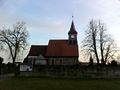
Ah, the famous Kirche Seeburg with its clock tower.
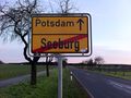
Proof that we left Seeburg. Oh, and it was so exciting there! ;)
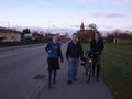
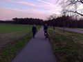
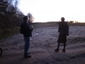
lyx, amuzulo and plypkie striding towards hashvana

the sun going down
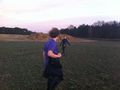
Lyx had to check out the haypile and run back while Relet looks on in envy.
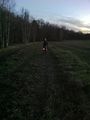
Exciting action shot of relet walking beside the highway.
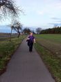
lyx walks while plypkie bikes.

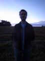
lyx smiling despite evil government chemtrails

lyx appreciating the local vegetation
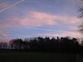
the moon braving the chemtrails
plypkie stumbling over a barn
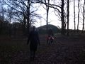
the hashfield, at last
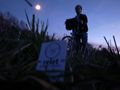
Shhh, I think plypkie hears a bird!

coordinates reached!
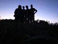
a group of four
amuzulo juggling at long exposures
a card, and a bad biker boy
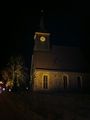
The church looks cool at night on the way back too!
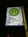
I saw that on the way back we would have to wait 70 minutes for a bus, so we decided to go to Potsdam in 20 minutes instead!
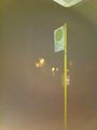
Relet said this picture perfectly represents our boredom waiting for the bus to go home via Potsdam.


Videos
Taken from Amuzulo's iPhone 4:
- Frisbee on the way!
- Panorama of geohash point
- Evidence of plykie's Circus Achievement
- plypkie and relet Juggle Together!
Achievements
plypkie, relet, amuzulo, and lyx earned the Land geohash achievement
|
plypkie, relet, amuzulo, and lyx earned the Circus Geohash Achievement
|
relet, amuzulo, and lyx earned the Public transport geohash achievement
|
plypkie earned the Bicycle geohash achievement
|