Difference between revisions of "2012-07-11 49 -123"
imported>Gercunderscore4 (→Expedition) |
m (More specific location) |
||
| (10 intermediate revisions by 6 users not shown) | |||
| Line 1: | Line 1: | ||
| − | |||
| − | |||
| − | |||
| − | |||
| − | |||
| − | |||
| − | |||
| − | |||
| − | |||
| − | |||
{{meetup graticule | {{meetup graticule | ||
| lat=49 | | lat=49 | ||
| Line 15: | Line 5: | ||
}} | }} | ||
| − | |||
__NOTOC__ | __NOTOC__ | ||
== Location == | == Location == | ||
Vancouver, in a back alley between 13th and 14th around Collinwood | Vancouver, in a back alley between 13th and 14th around Collinwood | ||
| − | + | ||
== Participants == | == Participants == | ||
| + | |||
* [[User:Wijnland|Wijnland]] | * [[User:Wijnland|Wijnland]] | ||
* [[User:gercunderscore4|GeRCunderscore4]] | * [[User:gercunderscore4|GeRCunderscore4]] | ||
| − | + | * [[User:Robbat2|Robbat2]] | |
| − | |||
== Plans == | == Plans == | ||
| − | it is only a few blocks from my route work\home, | + | it is only a few blocks from my route work\home, I'll pass by around 6/7 pm [[User:Wijnland|Wijnland]] |
| − | + | ||
== Expedition == | == Expedition == | ||
| − | + | ||
===GeRCunderscore4=== | ===GeRCunderscore4=== | ||
I just randomly checked the location today, and it happened to be very, very close to where I live. I saved a copy of the map to my phone (Google maps doesn't work on it), cycled over, and found the spot in a back alleyway. Robbat2 seems to have marked the spot, thanks for that, and there was an elderly couple nearby who mentioned that two others had been by. I took some pictures and come back home. I should probably mention that this is my first. | I just randomly checked the location today, and it happened to be very, very close to where I live. I saved a copy of the map to my phone (Google maps doesn't work on it), cycled over, and found the spot in a back alleyway. Robbat2 seems to have marked the spot, thanks for that, and there was an elderly couple nearby who mentioned that two others had been by. I took some pictures and come back home. I should probably mention that this is my first. | ||
| − | == | + | |
| − | + | ===Wijnland=== | |
| + | [[User:Wijnland|Wijnland]] 16:30, 11 July 2012 (PDT) : just back from a quick tour, did not have a camera or gps though... did see the marks of Robbat2! and just missed GeRC_4. Got a free :-) ! birthday slurpee at 7/11 afterwards at 10th/Alma (distance ~500m). | ||
| + | I am considering go for a second go tonight with gps and camera and for a second geoSquishi, anyone still up for a meet? drop me a time.. Just noticed that the free slurpees are only until 19.00 so there is little time. | ||
== Photos == | == Photos == | ||
| − | |||
| − | |||
| − | |||
<gallery perrow="5"> | <gallery perrow="5"> | ||
| + | Image:Photo1138s.jpg|Some else had already marked the spot. | ||
</gallery> | </gallery> | ||
== Achievements == | == Achievements == | ||
{{#vardefine:ribbonwidth|800px}} | {{#vardefine:ribbonwidth|800px}} | ||
| − | + | {{GeoSquishy 5Star | |
| + | | latitude = 49 | ||
| + | | longitude = -123 | ||
| + | | date = 2012-07-11 | ||
| + | | name = Wijnland | ||
| + | }} | ||
| + | {{GeoSquishy FirstSip | ||
| + | | latitude = 49 | ||
| + | | longitude = -123 | ||
| + | | date = 2012-07-11 | ||
| + | | name = Wijnland | ||
| + | }} | ||
| − | + | {{land geohash | |
| − | + | | latitude = 49 | |
| − | + | | longitude = -123 | |
| + | | date = 2012-07-11 | ||
| + | | name = GeRCunderscore4 | ||
| + | }} | ||
| − | + | {{Bicycle geohash | |
| + | | latitude = 49 | ||
| + | | longitude = -123 | ||
| + | | date = 2012-07-11 | ||
| + | | distance = 2.3 km | ||
| + | | name = GeRCunderscore4 | ||
| + | }} | ||
| + | * Land geohash | ||
| − | |||
| − | |||
| − | |||
[[Category:Expeditions]] | [[Category:Expeditions]] | ||
| − | |||
[[Category:Expeditions with photos]] | [[Category:Expeditions with photos]] | ||
| − | |||
| − | |||
| − | |||
| − | |||
| − | |||
[[Category:Coordinates reached]] | [[Category:Coordinates reached]] | ||
| − | + | {{location|CA|BC|MV}} | |
| − | |||
| − | |||
| − | |||
| − | |||
| − | |||
| − | |||
| − | |||
| − | |||
| − | |||
| − | |||
| − | |||
| − | |||
| − | |||
| − | |||
| − | |||
| − | |||
| − | |||
Latest revision as of 23:56, 9 August 2020
| Wed 11 Jul 2012 in 49,-123: 49.2603055, -123.1824329 geohashing.info google osm bing/os kml crox |
Location
Vancouver, in a back alley between 13th and 14th around Collinwood
Participants
Plans
it is only a few blocks from my route work\home, I'll pass by around 6/7 pm Wijnland
Expedition
GeRCunderscore4
I just randomly checked the location today, and it happened to be very, very close to where I live. I saved a copy of the map to my phone (Google maps doesn't work on it), cycled over, and found the spot in a back alleyway. Robbat2 seems to have marked the spot, thanks for that, and there was an elderly couple nearby who mentioned that two others had been by. I took some pictures and come back home. I should probably mention that this is my first.
Wijnland
Wijnland 16:30, 11 July 2012 (PDT) : just back from a quick tour, did not have a camera or gps though... did see the marks of Robbat2! and just missed GeRC_4. Got a free :-) ! birthday slurpee at 7/11 afterwards at 10th/Alma (distance ~500m). I am considering go for a second go tonight with gps and camera and for a second geoSquishi, anyone still up for a meet? drop me a time.. Just noticed that the free slurpees are only until 19.00 so there is little time.
Photos
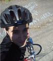
Some else had already marked the spot.

Achievements
Wijnland earned the 5 Star GeoSquishy Achievement
|
Wijnland earned the First Sip GeoSquishy Achievement
|
GeRCunderscore4 earned the Land geohash achievement
|
GeRCunderscore4 earned the Bicycle geohash achievement
|
- Land geohash