Difference between revisions of "2012-08-09 52 -1"
imported>Sourcerer (An expedition message sent via Geohash Droid for Android.) |
imported>FippeBot m (Location) |
||
| (6 intermediate revisions by one other user not shown) | |||
| Line 1: | Line 1: | ||
| − | |||
| − | |||
| − | |||
| − | |||
| − | |||
| − | |||
| − | |||
| − | |||
| − | |||
| − | |||
{{meetup graticule | {{meetup graticule | ||
| − | | lat=52 | + | | lat=52 |
| − | | lon=-1 | + | | lon=-1 |
| − | | date=2012-08-09 | + | | date=2012-08-09 |
| + | | graticule_name=Birmingham | ||
| + | | graticule_link=Birmingham, United Kingdom | ||
}} | }} | ||
| − | |||
| − | |||
== Location == | == Location == | ||
| − | + | ||
| + | 3) A few metres off a public footpath in a hay field. This was near the Grand Union Canal at Hatton. | ||
== Participants == | == Participants == | ||
| − | |||
| − | |||
| − | + | [[User:Sourcerer|Sourcerer]] | |
| − | |||
== Expedition == | == Expedition == | ||
| − | |||
| − | == | + | *Arrived. -- [[User:Sourcerer|Sourcerer]] [http://www.openstreetmap.org/?lat=52.312527894973755&lon=-1.6909074783325195&zoom=16&layers=B000FTF @52.3125,-1.6909] 13:11, 09 August 2012 (GMT+01:00) |
| − | |||
| − | + | 3 of 5 today :: [[2012-08-09_52 0]] :: [[2012-08-09_52_-0]] :: [[2012-08-09_52_-1]] :: [[2012-08-09_53_-2]] :: [[2012-08-09_56_-2]] | |
| − | |||
| − | |||
| − | -- | ||
| − | |||
| − | |||
| − | + | Neil was geohashing on the way to a wedding in Scotland. This was attempt three of five. The hashpoint was in a field 2.4 km from Hatton, on the Grand Union Canal. It is worth Googling for images of the flight of canal locks at Hatton. Finding a parking place was not easy. The road was in a narrow cutting with no verges. Neil parked illegally blocking the rear access to someone's garden. He was only away from the car for a few minutes and no one was inconvenienced. The hashpoint was a few metres off a public footpath. This was lucky as the friendly farmer was turning the hay harvest and a trespass would not have beeen a good idea. | |
| − | |||
| − | |||
| + | == Photos == | ||
| − | < | + | <gallery> |
| − | + | Image:2012-08-09 52 -1 Sourcerer 1.jpg|Google Earth Overview | |
| − | + | Image:2012-08-09 52 -1 Sourcerer 2.jpg|The Evidence | |
| + | Image:2012-08-09 52 -1 Sourcerer 3.jpg|The Terrain | ||
| + | Image:2012-08-09 52 -1 Sourcerer 4.jpg|The Terrain | ||
| + | </gallery> | ||
| − | + | {{Sourcerer_links | |
| − | + | | prev = 2012-08-09 52 -0 | |
| − | + | | curr = 2012-08-09 52 -1 | |
| − | -- | + | | next = 2012-08-09 53 -2 |
| + | | date = 2012-08-09 | ||
| + | }} | ||
| − | |||
[[Category:Expeditions]] | [[Category:Expeditions]] | ||
| − | |||
[[Category:Expeditions with photos]] | [[Category:Expeditions with photos]] | ||
| − | |||
| − | |||
| − | |||
| − | |||
| − | |||
[[Category:Coordinates reached]] | [[Category:Coordinates reached]] | ||
| − | + | {{location|GB|ENG|WAR}} | |
| − | |||
| − | |||
| − | |||
| − | |||
| − | |||
| − | |||
| − | |||
| − | |||
| − | |||
| − | |||
| − | |||
| − | |||
| − | |||
| − | |||
| − | |||
| − | |||
| − | |||
Latest revision as of 05:28, 13 August 2019
| Thu 9 Aug 2012 in Birmingham: 52.3125551, -1.6909587 geohashing.info google osm bing/os kml crox |
Contents
Location
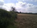
3) A few metres off a public footpath in a hay field. This was near the Grand Union Canal at Hatton.
Participants
Expedition
- Arrived. -- Sourcerer @52.3125,-1.6909 13:11, 09 August 2012 (GMT+01:00)
3 of 5 today :: 2012-08-09_52 0 :: 2012-08-09_52_-0 :: 2012-08-09_52_-1 :: 2012-08-09_53_-2 :: 2012-08-09_56_-2
Neil was geohashing on the way to a wedding in Scotland. This was attempt three of five. The hashpoint was in a field 2.4 km from Hatton, on the Grand Union Canal. It is worth Googling for images of the flight of canal locks at Hatton. Finding a parking place was not easy. The road was in a narrow cutting with no verges. Neil parked illegally blocking the rear access to someone's garden. He was only away from the car for a few minutes and no one was inconvenienced. The hashpoint was a few metres off a public footpath. This was lucky as the friendly farmer was turning the hay harvest and a trespass would not have beeen a good idea.
Photos
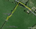
Google Earth Overview
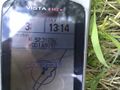
The Evidence

The Terrain
The Terrain


Expeditions and Plans
| 2012-08-09 | ||
|---|---|---|
| Atlanta, Georgia | NWoodruff | In a well over grown lot in Vinings. |
| Youngstown, Ohio | User:Fezzic181 | Found the spot out in the middle of the state game lands. |
| Billings, Montana | Rory | Lake Elmo State Park north of Billings, MT. The actual hash point is in th... |
| Northampton, United Kingdom | Sourcerer | 2) On an urban public path through attractive lawns and trees in Wellingbor... |
| Birmingham, United Kingdom | Sourcerer | 3) A few metres off a public footpath in a hay field. This was near the Gra... |
| Cambridge, United Kingdom | Sourcerer | 1) Sourcerer failed to reach the hashpoint in a very muddy pig field. |
| Amsterdam, Netherlands | Marvyn | Behind a container-like building in some shrubs in an urban area in Hoofddo... |
| Manchester, United Kingdom | Sourcerer | 4) Close to junction 12 on the M56. The hashpoint was on or very close to t... |
| Dundee, United Kingdom | Sourcerer | 5) Beside the coast road east of St. Andrews, Fife, Scotland, UK. |
Sourcerer's Expedition Links
2012-08-09 52 -0 - 2012-08-09 52 -1 - 2012-08-09 53 -2 - KML file download of Sourcerer's expeditions for use with Google Earth.