Difference between revisions of "2012-08-09 56 -2"
imported>Sourcerer ([live] Arrived.) |
imported>FippeBot m (Location) |
||
| (12 intermediate revisions by one other user not shown) | |||
| Line 1: | Line 1: | ||
| − | |||
| − | |||
| − | |||
| − | |||
| − | |||
| − | |||
| − | |||
| − | |||
| − | |||
| − | |||
{{meetup graticule | {{meetup graticule | ||
| − | | lat=56 | + | | lat=56 |
| − | | lon=-2 | + | | lon=-2 |
| − | | date=2012-08-09 | + | | date=2012-08-09 |
| + | | graticule_name=Dundee, UK | ||
| + | | graticule_link=Dundee, United Kingdom | ||
}} | }} | ||
| − | |||
| − | |||
== Location == | == Location == | ||
| − | + | ||
| + | 5) Beside the coast road east of St. Andrews, Fife, Scotland, UK. | ||
== Participants == | == Participants == | ||
| − | |||
| − | |||
| − | + | [[User:Sourcerer|Sourcerer]] | |
| − | |||
== Expedition == | == Expedition == | ||
| − | |||
| + | *Arrived. -- [[User:Sourcerer|Sourcerer]] [http://www.openstreetmap.org/?lat=56.312554478645325&lon=-2.6909905672073364&zoom=16&layers=B000FTF @56.3126,-2.6910] 21:19, 09 August 2012 (GMT+01:00) | ||
| + | |||
| + | 5 of 5 today :: [[2012-08-09_52 0]] :: [[2012-08-09_52_-0]] :: [[2012-08-09_52_-1]] :: [[2012-08-09_53_-2]] :: [[2012-08-09_56_-2]] | ||
| − | + | Neil was geohashing on the way to a wedding in Scotland. This was attempt five of Five. This was the second new graticule of the day and in a new country for good measure. The hashpoint was beside the coast road 7.2 km east of St. Andrew's, Fife, Scotland (The one famous for golf). It was in a damp field of barley. The variety was unusual or perhaps just stunted by the bad weather earlier in the year. Neil walked up the tractor tracks without damaging the crop. The first tracks missed the hashpoint so a parallel line further east was tried. This worked perfectly and the distance dropped to zero. It was getting dark so the evidence photos are not so good. After this expedition, Neil met his friends for a beer. It's their son James who's getting married to Rachel. The hashpoints in latitude 54 and 55 were not at all convenient to get to. This journey was already long and tiring without adding these extra points. This was originally believed to be a virgin achievement but closer checking revealed another expedition in [[2009-08-16_56_-2|2009]] by [[User:Jones|Jones]]. I have added a link from the Dundee page to this expedition. | |
| − | |||
| − | |||
== Photos == | == Photos == | ||
| − | < | + | |
| − | Image: | + | <gallery> |
| − | -- | + | Image:2012-08-09 56 -2 Sourcerer 1.jpg|Google Earth Overview |
| − | + | Image:2012-08-09 56 -2 Sourcerer 2.jpg|The Terrain | |
| + | Image:2012-08-09 56 -2 Sourcerer 3.jpg|The Evidence | ||
</gallery> | </gallery> | ||
== Achievements == | == Achievements == | ||
| − | {{#vardefine:ribbonwidth| | + | {{#vardefine:ribbonwidth|700px}} |
| − | + | {{Multihash2 | |
| + | | count = 4 | ||
| + | | date = 2012-08-09 | ||
| + | | name = Sourcerer | ||
| + | }} | ||
| + | {{Border geohash achievement | ||
| + | | latitude = 56 | ||
| + | | longitude = -2 | ||
| + | | date = 2012-08-09 | ||
| + | | country1 = England | ||
| + | | country2 = Scotland | ||
| + | | name = Sourcerer | ||
| + | }} | ||
| + | {{Sourcerer_links | ||
| + | | prev = 2012-08-09 53 -2 | ||
| + | | curr = 2012-08-09 56 -2 | ||
| + | | next = 2012-08-10 56 -3 | ||
| + | | date = 2012-08-09 | ||
| + | }} | ||
| − | |||
| − | |||
| − | |||
| − | |||
| − | |||
| − | |||
| − | |||
| − | |||
| − | |||
| − | |||
[[Category:Expeditions]] | [[Category:Expeditions]] | ||
| − | |||
[[Category:Expeditions with photos]] | [[Category:Expeditions with photos]] | ||
| − | |||
| − | |||
| − | |||
| − | |||
| − | |||
[[Category:Coordinates reached]] | [[Category:Coordinates reached]] | ||
| − | + | {{location|GB|SCT|FIF}} | |
| − | |||
| − | |||
| − | |||
| − | |||
| − | |||
| − | |||
| − | |||
| − | |||
| − | |||
| − | |||
| − | |||
| − | |||
| − | |||
| − | |||
| − | |||
| − | |||
| − | |||
Latest revision as of 05:29, 13 August 2019
| Thu 9 Aug 2012 in Dundee, UK: 56.3125551, -2.6909587 geohashing.info google osm bing/os kml crox |
Contents
Location
5) Beside the coast road east of St. Andrews, Fife, Scotland, UK.
Participants
Expedition
- Arrived. -- Sourcerer @56.3126,-2.6910 21:19, 09 August 2012 (GMT+01:00)
5 of 5 today :: 2012-08-09_52 0 :: 2012-08-09_52_-0 :: 2012-08-09_52_-1 :: 2012-08-09_53_-2 :: 2012-08-09_56_-2
Neil was geohashing on the way to a wedding in Scotland. This was attempt five of Five. This was the second new graticule of the day and in a new country for good measure. The hashpoint was beside the coast road 7.2 km east of St. Andrew's, Fife, Scotland (The one famous for golf). It was in a damp field of barley. The variety was unusual or perhaps just stunted by the bad weather earlier in the year. Neil walked up the tractor tracks without damaging the crop. The first tracks missed the hashpoint so a parallel line further east was tried. This worked perfectly and the distance dropped to zero. It was getting dark so the evidence photos are not so good. After this expedition, Neil met his friends for a beer. It's their son James who's getting married to Rachel. The hashpoints in latitude 54 and 55 were not at all convenient to get to. This journey was already long and tiring without adding these extra points. This was originally believed to be a virgin achievement but closer checking revealed another expedition in 2009 by Jones. I have added a link from the Dundee page to this expedition.
Photos
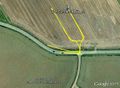
Google Earth Overview
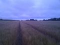
The Terrain
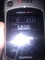
The Evidence


Achievements
Sourcerer earned the Multihash Achievement
|
Sourcerer earned the Border geohash achievement
|
Expeditions and Plans
| 2012-08-09 | ||
|---|---|---|
| Atlanta, Georgia | NWoodruff | In a well over grown lot in Vinings. |
| Youngstown, Ohio | User:Fezzic181 | Found the spot out in the middle of the state game lands. |
| Billings, Montana | Rory | Lake Elmo State Park north of Billings, MT. The actual hash point is in th... |
| Northampton, United Kingdom | Sourcerer | 2) On an urban public path through attractive lawns and trees in Wellingbor... |
| Birmingham, United Kingdom | Sourcerer | 3) A few metres off a public footpath in a hay field. This was near the Gra... |
| Cambridge, United Kingdom | Sourcerer | 1) Sourcerer failed to reach the hashpoint in a very muddy pig field. |
| Amsterdam, Netherlands | Marvyn | Behind a container-like building in some shrubs in an urban area in Hoofddo... |
| Manchester, United Kingdom | Sourcerer | 4) Close to junction 12 on the M56. The hashpoint was on or very close to t... |
| Dundee, United Kingdom | Sourcerer | 5) Beside the coast road east of St. Andrews, Fife, Scotland, UK. |
Sourcerer's Expedition Links
2012-08-09 53 -2 - 2012-08-09 56 -2 - 2012-08-10 56 -3 - KML file download of Sourcerer's expeditions for use with Google Earth.