Difference between revisions of "A beginner's guide"
imported>Amoebakate m (→Visit the hashpoint) |
(→Visit the hashpoint) |
||
| (3 intermediate revisions by 3 users not shown) | |||
| Line 5: | Line 5: | ||
=== Find a hashpoint === | === Find a hashpoint === | ||
| − | '''Use your smartphone:''' There | + | '''Use your smartphone:''' There is a [https://play.google.com/store/apps/details?id=net.exclaimindustries.geohashdroid Geohashing app for Android], an [[gHash|app for iOS]] is under development as of 2021. These are ideal for locating the daily hashpoint positions. |
| − | '''Use | + | '''Use a web browser:''' A good method is to visit '''[https://geohashing.info/ Geohashing.info]''' and '''click on the map'''. For slightly more experienced geohashers, there are other [[implementations]]. |
| − | [[File: | + | [[File:Geohashing info v2.png]] |
=== Visit the hashpoint === | === Visit the hashpoint === | ||
Go whenever you like but beware: each day at midnight the hashpoint moves to its new position. Like Cinderella, make sure you meet this deadline. If you arrive at 4pm on Saturday, you are more likely to meet another geohasher. In most parts of the world, this is the official meetup time. | Go whenever you like but beware: each day at midnight the hashpoint moves to its new position. Like Cinderella, make sure you meet this deadline. If you arrive at 4pm on Saturday, you are more likely to meet another geohasher. In most parts of the world, this is the official meetup time. | ||
| + | |||
| + | Get as close as you can, for some definition of [[success]]. | ||
If you're using a smartphone to locate the hashpoint, you can use it to log your arrival on the wiki. This is useful because it will create a correctly named wiki page. For this to work, you will need a wiki account and you'll need to tell the phone app your wiki log-in details. | If you're using a smartphone to locate the hashpoint, you can use it to log your arrival on the wiki. This is useful because it will create a correctly named wiki page. For this to work, you will need a wiki account and you'll need to tell the phone app your wiki log-in details. | ||
=== Share your experience === | === Share your experience === | ||
| + | Before making your first pages, [[Special:CreateAccount|create an account]] for yourself on this wiki. | ||
| − | + | Visit [https://geohashing.info Geohashing.info], find the point you visited and click the '''Meetup''' link (top right). To add your expedition details, you'll need to edit this page. If the page already exists, you can add to it. Otherwise you should copy the block below and paste it into your new page. | |
| − | |||
| − | Visit | ||
| − | |||
| − | |||
| − | |||
| − | |||
| − | |||
| − | |||
| − | + | <pre style="font-size:12px;">{{subst:Expedition}}</pre> | |
Geohashers like to read each others expedition reports. Most are interesting and some are great fun. Read these [[Geohashing_Quotes|Geohashing quotes]]. | Geohashers like to read each others expedition reports. Most are interesting and some are great fun. Read these [[Geohashing_Quotes|Geohashing quotes]]. | ||
| Line 46: | Line 41: | ||
=== Add the expedition to the correct graticule page === | === Add the expedition to the correct graticule page === | ||
| − | + | [[File:Graticule link screenshot.png|thumb|Finding the link to your graticule]] | |
| − | + | On your expedition page, you will find a box which looks similar to the one pictured to the right. The graticule link is highlighted in the screenshot. After following the graticule link, edit the graticule page. | |
Add your expedition copying the style of the entries of the other page users. Here is an example you can copy if you are the first to add to the page. | Add your expedition copying the style of the entries of the other page users. Here is an example you can copy if you are the first to add to the page. | ||
| Line 115: | Line 110: | ||
[[Category:Expeditions with photos]] | [[Category:Expeditions with photos]] | ||
[[Category:Coordinates not reached]] | [[Category:Coordinates not reached]] | ||
| − | [[Category:Not reached - | + | [[Category:Not reached - Mother Nature]] |
</pre> | </pre> | ||
[[Category:Geohashing guide]] | [[Category:Geohashing guide]] | ||
Latest revision as of 06:39, 16 July 2024
Contents
This is a one page summary
Here are some more comprehensive instructions.
Find a hashpoint
Use your smartphone: There is a Geohashing app for Android, an app for iOS is under development as of 2021. These are ideal for locating the daily hashpoint positions.
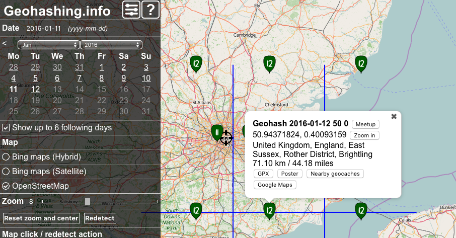
Use a web browser: A good method is to visit Geohashing.info and click on the map. For slightly more experienced geohashers, there are other implementations.
Visit the hashpoint
Go whenever you like but beware: each day at midnight the hashpoint moves to its new position. Like Cinderella, make sure you meet this deadline. If you arrive at 4pm on Saturday, you are more likely to meet another geohasher. In most parts of the world, this is the official meetup time.
Get as close as you can, for some definition of success.
If you're using a smartphone to locate the hashpoint, you can use it to log your arrival on the wiki. This is useful because it will create a correctly named wiki page. For this to work, you will need a wiki account and you'll need to tell the phone app your wiki log-in details.
Before making your first pages, create an account for yourself on this wiki.
Visit Geohashing.info, find the point you visited and click the Meetup link (top right). To add your expedition details, you'll need to edit this page. If the page already exists, you can add to it. Otherwise you should copy the block below and paste it into your new page.
{{subst:Expedition}}
Geohashers like to read each others expedition reports. Most are interesting and some are great fun. Read these Geohashing quotes.
Have a look at this example 2012-07-22 55 -17 for a bare-bones completed report.
Add the expedition to your own user page
This is an example of what you type.
* [[2012-08-16 52 1]] On the west bank of the river Bure, Upton near Acle, Norfolk, UK.
- 2012-08-16 52 1 On the west bank of the river Bure, Upton near Acle, Norfolk, UK.
Change the date, latitude, longitude and text to match your expedition.
Add the expedition to the correct graticule page
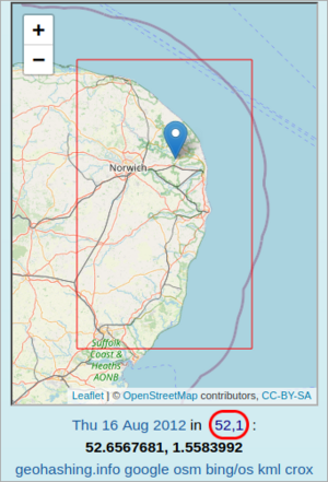
On your expedition page, you will find a box which looks similar to the one pictured to the right. The graticule link is highlighted in the screenshot. After following the graticule link, edit the graticule page.
Add your expedition copying the style of the entries of the other page users. Here is an example you can copy if you are the first to add to the page.
* [[2012-08-16 52 1|2012-08-16]]: [[User:Sourcerer|Sourcerer]] visited the west etc.
- 2012-08-16 Sourcerer visited the west bank bank of the river Bure, Upton near Acle, Norfolk, UK.
Change the date, latitude, longitude, date, user and text to match you and your expedition.
Learn more
Look at other user's pages and expedition reports. Also look at the graticule pages to see how people record their expeditions. Click edit and borrow examples of their code for your own re-use and finally click back to quit editing without saving.
If you have got this far, you have also learned how to edit sites like Wikipedia. Useful!
For more advanced techniques, there are many more help pages here.
Example code for an expedition report
{{meetup graticule
  | lat=55
  | lon=-17
  | date=2012-07-22
}}

== Location ==

Somewhere in the north Atlantic.

== Participants ==

[[User:Sourcerer|Sourcerer]]

== Plans ==

Here are my plans.

== Expedition ==

This is only an example.

== Tracklog ==

Most people delete this section. It's useful for some.

== Photos ==

<gallery perrow="5">
Image:2011-06-26 52 0 Sourcerer 18.jpg | This is an example of good evidence
</gallery>

== Achievements ==
{{#vardefine:ribbonwidth|800px}}

{{water geohash
  | latitude = 55
  | longitude = -17
  | date = 2012-07-22
  | name = Sourcerer
  | image = 2011-12-19 43 32 Sourcerer 6 Hash Kitty.jpg
  | vehicle = fantasy
}}

[[Category:Expeditions]]
[[Category:Expeditions with photos]]
[[Category:Coordinates not reached]]
[[Category:Not reached - Mother Nature]]

