Difference between revisions of "2012-10-19 53 8"
imported>Pah ([live picture] Birthday geohashing... [http://www.openstreetmap.org/?lat=53.01984393&lon=8.10684322&zoom=16&layers=B000FTF @53.0198,8.1068]) |
imported>Fippe m (Location) |
||
| (7 intermediate revisions by one other user not shown) | |||
| Line 1: | Line 1: | ||
| − | |||
| − | |||
| − | |||
| − | |||
| − | |||
| − | |||
| − | |||
| − | |||
| − | |||
| − | |||
{{meetup graticule | {{meetup graticule | ||
| lat=53 | | lat=53 | ||
| Line 15: | Line 5: | ||
}} | }} | ||
| − | |||
__NOTOC__ | __NOTOC__ | ||
== Location == | == Location == | ||
| − | + | ||
| + | A (harvested) corn field in near to | ||
| + | [[wikipedia:Wardenburg|Wardenburg]], | ||
| + | about 10 kilometers south of | ||
| + | [[wikipedia:Oldenburg|Oldenburg]]. | ||
== Participants == | == Participants == | ||
| − | |||
| − | |||
| − | + | * [[User:Pah|pah]] (prev|[[2013-07-20 53 8|next]]) | |
| − | + | * Lena | |
== Expedition == | == Expedition == | ||
| − | |||
| − | + | We (Lena and [[User:Pah|pah]]) went on our first geohashing trip for | |
| − | + | [[2012-10-19|today]]'s hashpoint in the graticule [[53,8]]. It has been a | |
| + | long-standing plan to start geohashing, and finally on [[User:Pah|my]] | ||
| + | birthday, we made it come true. | ||
| + | |||
| + | The location has been fairly easy to reach by car in an 30-minute trip from | ||
| + | [https://en.wikipedia.org/wiki/Oldenburg Oldenburg]. It is located in a fairly | ||
| + | rural area with little to no parking space and quite narrow streets full of | ||
| + | loaded farm trailers. After a short walk we've reached the coordinates at three | ||
| + | minutes to 4 p.m. We're usually not known for being that precisely on time… | ||
| + | |||
| + | On our way, we've met "locals", especially a small dog, who was very excited to | ||
| + | see strangers from the city. The accompanying woman looked a bit more | ||
| + | surprised, even more so when she saw us leaving the driveway to elegantly | ||
| + | (*cough*) jump over the ditch into the field. | ||
| + | |||
| + | Since the GPS accuray of the smartphone was quite limited, we've stumbled | ||
| + | around the final coordinates and didn't manage to lock in exactly. The | ||
| + | coordinates registered in the pictures include a bigger offset than the best | ||
| + | results when placing the mandatory note (see picture). | ||
| + | |||
| + | The first two pictures were uploaded with the GeoDroid app. Hopefully this | ||
| + | includes enough proof. Next time, we'll try to document the trip in more detail. | ||
| + | Unfortunately (but not really unexpectedly), no one else showed up. | ||
| + | |||
| + | After staying around for a while, we decided to have a walk around the area and | ||
| + | we found quite some nice mushrooms and butterflies. It was a great trip and we | ||
| + | definitely want to go for further hashes in the future. | ||
| + | |||
== Photos == | == Photos == | ||
| − | + | ||
| − | |||
| − | |||
<gallery perrow="5"> | <gallery perrow="5"> | ||
| − | |||
Image:2012-10-19_53_8_16-02-30-758.jpg | Birthday geohashing... [http://www.openstreetmap.org/?lat=53.01984393&lon=8.10684322&zoom=16&layers=B000FTF @53.0198,8.1068] | Image:2012-10-19_53_8_16-02-30-758.jpg | Birthday geohashing... [http://www.openstreetmap.org/?lat=53.01984393&lon=8.10684322&zoom=16&layers=B000FTF @53.0198,8.1068] | ||
| + | Image:2012-10-19_53_8_16-03-12-304.jpg | [[User:Pah|pah]] [http://www.openstreetmap.org/?lat=53.01981262&lon=8.10682302&zoom=16&layers=B000FTF @53.0198,8.1068] | ||
| + | Image:2012-10-19_53_8_16-00-32.jpg | Lena [http://www.openstreetmap.org/?lat=53.01981262&lon=8.10682302&zoom=16&layers=B000FTF @53.0198,8.1068] | ||
</gallery> | </gallery> | ||
== Achievements == | == Achievements == | ||
| + | |||
{{#vardefine:ribbonwidth|800px}} | {{#vardefine:ribbonwidth|800px}} | ||
<!-- Add any achievement ribbons you earned below, or remove this section --> | <!-- Add any achievement ribbons you earned below, or remove this section --> | ||
| + | {{Birthday geohash | ||
| + | | latitude = 53 | ||
| + | | longitude = 8 | ||
| + | | date = 2012-10-19 | ||
| + | | pronoun = his | ||
| + | | number = 35th | ||
| + | | name = [[User:Pah|pah]] [[File:U+110DB.png|middle|6px|link=User:Pah]] | ||
| + | }} | ||
| − | + | {{land geohash | |
| − | + | | latitude = 53 | |
| − | [[ | + | | longitude = 8 |
| − | + | | date = 2012-10-19 | |
| − | + | | name = [[User:Pah|pah]] [[File:U+110DB.png|middle|6px|link=User:Pah]] | |
| − | + | }} | |
| − | [[ | + | {{Two to the N achievement |
| − | - | + | | count = 0 |
| − | + | | date = 2012-10-19 | |
| − | + | | latitude = 53 | |
| + | | longitude = 8 | ||
| + | | name = [[User:Pah|pah]] [[File:U+110DB.png|middle|6px|link=User:Pah]] | ||
| + | | reached = true (optional - include if you are counting coordinates reached) | ||
| + | }} | ||
[[Category:Expeditions]] | [[Category:Expeditions]] | ||
| − | |||
[[Category:Expeditions with photos]] | [[Category:Expeditions with photos]] | ||
| − | |||
| − | |||
| − | |||
| − | |||
| − | |||
[[Category:Coordinates reached]] | [[Category:Coordinates reached]] | ||
| − | + | {{location|DE|NI|OL}} | |
| − | |||
| − | |||
| − | |||
| − | |||
| − | |||
| − | |||
| − | |||
| − | |||
| − | |||
| − | |||
| − | |||
| − | |||
| − | |||
| − | |||
| − | |||
| − | |||
| − | |||
Latest revision as of 18:50, 24 July 2019
| Fri 19 Oct 2012 in 53,8: 53.0198242, 8.1068597 geohashing.info google osm bing/os kml crox |
Location
A (harvested) corn field in near to Wardenburg, about 10 kilometers south of Oldenburg.
Participants
Expedition
We (Lena and pah) went on our first geohashing trip for today's hashpoint in the graticule 53,8. It has been a long-standing plan to start geohashing, and finally on my birthday, we made it come true.
The location has been fairly easy to reach by car in an 30-minute trip from Oldenburg. It is located in a fairly rural area with little to no parking space and quite narrow streets full of loaded farm trailers. After a short walk we've reached the coordinates at three minutes to 4 p.m. We're usually not known for being that precisely on time…
On our way, we've met "locals", especially a small dog, who was very excited to see strangers from the city. The accompanying woman looked a bit more surprised, even more so when she saw us leaving the driveway to elegantly (*cough*) jump over the ditch into the field.
Since the GPS accuray of the smartphone was quite limited, we've stumbled around the final coordinates and didn't manage to lock in exactly. The coordinates registered in the pictures include a bigger offset than the best results when placing the mandatory note (see picture).
The first two pictures were uploaded with the GeoDroid app. Hopefully this includes enough proof. Next time, we'll try to document the trip in more detail. Unfortunately (but not really unexpectedly), no one else showed up.
After staying around for a while, we decided to have a walk around the area and we found quite some nice mushrooms and butterflies. It was a great trip and we definitely want to go for further hashes in the future.
Photos
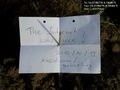
Birthday geohashing... @53.0198,8.1068
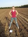
Lena @53.0198,8.1068


Achievements
pah
|
pah
|
pah
|