Difference between revisions of "2012-11-04 52 0"
imported>Sourcerer m (An expedition message sent via Geohash Droid for Android.) |
imported>FippeBot m (Location) |
||
| (14 intermediate revisions by one other user not shown) | |||
| Line 1: | Line 1: | ||
| − | |||
| − | |||
| − | |||
| − | |||
| − | |||
| − | |||
| − | |||
| − | |||
| − | |||
| − | |||
{{meetup graticule | {{meetup graticule | ||
| − | | lat=52 | + | | lat=52 |
| − | | lon=0 | + | | lon=0 |
| − | | date=2012-11-04 | + | | date=2012-11-04 |
| + | | graticule_name=Cambridge | ||
| + | | graticule_link=Cambridge, United Kingdom | ||
}} | }} | ||
| − | |||
| − | |||
== Location == | == Location == | ||
| − | + | ||
| + | 3) On the centre line of the A149 trunk road close to Sculthorpe Airfield. | ||
| + | |||
| + | [[2012-11-04 52 -1]] :: [[2012-11-04 52 -0]] :: [[2012-11-04 52 0]] | ||
== Participants == | == Participants == | ||
| − | |||
| − | |||
| − | + | * [[User:Sourcerer|Sourcerer]] | |
| − | + | * [[User:Sourcerer|Sourcerer]] again on 2015-05-29 as an accidental retrohash. | |
| + | * [[User:Sourcerer|Sourcerer]] again on 2016-04-18 22:55 retrohash. | ||
| + | * [[User:Sourcerer|Sourcerer]] again on 2016-04-19 00:34 retrohash. | ||
== Expedition == | == Expedition == | ||
| − | |||
| − | == | + | *Arrived. -- [[User:Sourcerer|Sourcerer]] [http://www.openstreetmap.org/?lat=52.8423285484314&lon=0.7904094457626343&zoom=16&layers=B000FTF @52.8423,.7904] 16:15, 04 November 2012 (GMT) |
| − | + | ||
| + | This was attempt three of three on this day. Neil was returning from a beer and curry themed visit to good friends in Staffordshire. The hashpoint was on the centre line of the busy A149 trunk road across north Norfolk. During a rare pause in the traffic, in the pouring rain, Neil walked into the middle of the road. It remained safe for about ten seconds before a hasty retreat was necessary. There was a layby right by the hashpoint so it was really easy to park and walk a few metres to the point. Sculthorpe airfield was the closest landmark. | ||
== Photos == | == Photos == | ||
| − | < | + | |
| − | Image:2012- | + | <gallery> |
| − | -- | + | Image:2012-11-04 52 0 Sourcerer.jpg|The Main Road Hashpoint |
| − | + | Image:2012-11-04 52 0 Sourcerer Retro.jpg | Unavoidable Retrohashes | |
</gallery> | </gallery> | ||
== Achievements == | == Achievements == | ||
{{#vardefine:ribbonwidth|800px}} | {{#vardefine:ribbonwidth|800px}} | ||
| − | + | {{ | |
| + | Multihash2 | | ||
| + | count = 2 | | ||
| + | date = 2012-11-04 | | ||
| + | name = Sourcerer | ||
| + | }} | ||
| + | {{gratuitous ribbon | ||
| + | | latitude = 52 | ||
| + | | longitude = 0 | ||
| + | | date = 2015-05-29 | ||
| + | | achievement = Serendipitous Retrohash Achievement | ||
| + | | description = revisiting this hashpoint before midnight on the way to another nearby | ||
| + | | name = Sourcerer | ||
| + | }} | ||
| + | {{Sourcerer_links | ||
| + | | prev = 2012-11-04 52 -0 | ||
| + | | curr = 2012-11-04 52 0 | ||
| + | | next = 2012-12-16 52 1 | ||
| + | | date = 2012-11-04 | ||
| + | }} | ||
| − | |||
| − | |||
| − | |||
| − | |||
| − | |||
| − | |||
| − | |||
| − | |||
| − | |||
| − | |||
[[Category:Expeditions]] | [[Category:Expeditions]] | ||
| − | |||
[[Category:Expeditions with photos]] | [[Category:Expeditions with photos]] | ||
| − | |||
| − | |||
| − | |||
| − | |||
| − | |||
[[Category:Coordinates reached]] | [[Category:Coordinates reached]] | ||
| − | + | [[Category:Retro meetup]] | |
| − | + | [[Category:Retro coordinates reached]] | |
| − | + | {{location|GB|ENG|NFK}} | |
| − | |||
| − | |||
| − | |||
| − | |||
| − | |||
| − | |||
| − | [[Category: | ||
| − | |||
| − | |||
| − | [[Category: | ||
| − | |||
| − | |||
| − | |||
| − | |||
| − | |||
Latest revision as of 06:47, 13 August 2019
| Sun 4 Nov 2012 in Cambridge: 52.8422319, 0.7904151 geohashing.info google osm bing/os kml crox |
Contents
Location
3) On the centre line of the A149 trunk road close to Sculthorpe Airfield.
2012-11-04 52 -1 :: 2012-11-04 52 -0 :: 2012-11-04 52 0
Participants
- Sourcerer
- Sourcerer again on 2015-05-29 as an accidental retrohash.
- Sourcerer again on 2016-04-18 22:55 retrohash.
- Sourcerer again on 2016-04-19 00:34 retrohash.
Expedition
- Arrived. -- Sourcerer @52.8423,.7904 16:15, 04 November 2012 (GMT)
This was attempt three of three on this day. Neil was returning from a beer and curry themed visit to good friends in Staffordshire. The hashpoint was on the centre line of the busy A149 trunk road across north Norfolk. During a rare pause in the traffic, in the pouring rain, Neil walked into the middle of the road. It remained safe for about ten seconds before a hasty retreat was necessary. There was a layby right by the hashpoint so it was really easy to park and walk a few metres to the point. Sculthorpe airfield was the closest landmark.
Photos
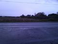
The Main Road Hashpoint
Unavoidable Retrohashes


Achievements
Sourcerer earned the Multihash Achievement
|
Sourcerer earned the Serendipitous Retrohash Achievement
|
Expeditions and Plans
| 2012-11-04 | ||
|---|---|---|
| Shepparton, Australia | Felix Dance | In a field south of Violet Town at night. |
| Gainesville, Florida | Grumpa | A stand of trees on a pasture in the middle of a bunch of private property.... |
| Tecate, Mexico | LucasBrown | A lot fenced in on three sides off Tavern Road in Alpine, CA |
| Brighton, United Kingdom | Haberdasher | just outside a commercial building in Chichester. |
| Northampton, United Kingdom | Sourcerer | 2) On a field boundary halfway between Melton Mowbray, famous for pork pies... |
| Birmingham, United Kingdom | Sourcerer | 1) In a field 42 metres off a narrow rural lane. The nearest big town was U... |
| Cambridge, United Kingdom | Sourcerer | 3) On the centre line of the A149 trunk road close to Sculthorpe Airfield. ... |
Sourcerer's Expedition Links
2012-11-04 52 -0 - 2012-11-04 52 0 - 2012-12-16 52 1 - KML file download of Sourcerer's expeditions for use with Google Earth.