Difference between revisions of "2014-03-06 52 1"
imported>Sourcerer (→Sourcerer New Expedition) |
imported>FippeBot m (Location) |
||
| (2 intermediate revisions by one other user not shown) | |||
| Line 21: | Line 21: | ||
A detour after work lead to this hashpoint. It was a clear night with a waxing moon and driving conditions were good. Sadly this did not prevent a small deer from walking straight into my path. There was no time to brake and the poor creature got hit at 80 km/h. It was a perfect head on collision so there would have been no suffering. On a previous expedition I awarded myself the gratuitous "Bambihash" for deer spotting so today, with regret, I get the Bambimash. | A detour after work lead to this hashpoint. It was a clear night with a waxing moon and driving conditions were good. Sadly this did not prevent a small deer from walking straight into my path. There was no time to brake and the poor creature got hit at 80 km/h. It was a perfect head on collision so there would have been no suffering. On a previous expedition I awarded myself the gratuitous "Bambihash" for deer spotting so today, with regret, I get the Bambimash. | ||
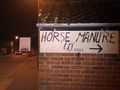
| − | The hashpoint was in the front yard of a house in North Walsham. There was a convenient wall to balance the GPSR for the evidence photo. The manure photo is also clearly visible on Google street view. Manure hashes are an amusing feature of rural geohashing. | + | The hashpoint was in the front yard of a house in North Walsham. There was a convenient wall to balance the GPSR for the evidence photo. The manure photo is also clearly visible on Google street view. Manure hashes are an amusing feature of rural geohashing. I banged my head on the bus stop sign which was hanging upside down after four months of storm winds. |
== Photos == | == Photos == | ||
| Line 40: | Line 40: | ||
}} | }} | ||
| − | == | + | {{Sourcerer_links |
| − | + | | prev = 2014-02-07 52 1 | |
| − | + | | curr = 2014-03-06 52 1 | |
| + | | next = 2014-04-27 52 1 | ||
| + | | date = 2014-03-06 | ||
| + | }} | ||
[[Category:Expeditions]] | [[Category:Expeditions]] | ||
[[Category:Expeditions with photos]] | [[Category:Expeditions with photos]] | ||
[[Category:Coordinates reached]] | [[Category:Coordinates reached]] | ||
| + | {{location|GB|ENG|NFK}} | ||
Latest revision as of 05:47, 14 August 2019
| Thu 6 Mar 2014 in Norwich: 52.8153834, 1.3810186 geohashing.info google osm bing/os kml crox |
Contents
Location
A roadside hashpoint close to North Walsham railway station, Norfolk, UK.
Participants
Expedition
- Arrived. -- Sourcerer (talk) @52.8153,1.3811 20:00, 06 March 2014 (GMT)
A detour after work lead to this hashpoint. It was a clear night with a waxing moon and driving conditions were good. Sadly this did not prevent a small deer from walking straight into my path. There was no time to brake and the poor creature got hit at 80 km/h. It was a perfect head on collision so there would have been no suffering. On a previous expedition I awarded myself the gratuitous "Bambihash" for deer spotting so today, with regret, I get the Bambimash.
The hashpoint was in the front yard of a house in North Walsham. There was a convenient wall to balance the GPSR for the evidence photo. The manure photo is also clearly visible on Google street view. Manure hashes are an amusing feature of rural geohashing. I banged my head on the bus stop sign which was hanging upside down after four months of storm winds.
Photos
The Hashpoint


Achievements
Sourcerer earned the Bambimash
|
Expeditions and Plans
| 2014-03-06 | ||
|---|---|---|
| Des Moines, Iowa | Chair | located on West 1st Street in Grimes. |
| The Dalles, Oregon | kydlt | Outside Cascade Locks, OR |
| Paris, France | Dunaril, Katu | On a sidewalk, along a college in the center of Ivry-sur-Seine, Val-de-Marn... |
| Most, Czech Republic | Danatar | in a meadow near Helbigsdorf, a part of Mulda. Country: Germany; state: Sa... |
| Norwich, United Kingdom | Sourcerer | A roadside hashpoint close to North Walsham railway station, Norfolk, UK. |
Sourcerer's Expedition Links
2014-02-07 52 1 - 2014-03-06 52 1 - 2014-04-27 52 1 - KML file download of Sourcerer's expeditions for use with Google Earth.