Difference between revisions of "2014-08-30 51 9"
imported>GeorgDerReisende (create page) |
m (Linking to The Dance™) |
||
| (3 intermediate revisions by 2 users not shown) | |||
| Line 1: | Line 1: | ||
| − | |||
| − | |||
| − | |||
| − | |||
| − | |||
| − | |||
| − | |||
| − | |||
| − | |||
| − | |||
{{meetup graticule | {{meetup graticule | ||
| lat=51 | | lat=51 | ||
| Line 18: | Line 8: | ||
__NOTOC__ | __NOTOC__ | ||
== Location == | == Location == | ||
| − | + | ||
| + | The hash lay at a fence in Gudensberg. | ||
== Participants == | == Participants == | ||
| − | + | ||
| − | + | [[User:GeorgDerReisende|GeorgDerReisende]] | |
== Plans == | == Plans == | ||
| − | + | ||
| + | Today I wanted to take the bus from Kassel to Gudensberg, because I don't know a good place for hitchhiking onto the A49 motorway. | ||
== Expedition == | == Expedition == | ||
| − | |||
| − | + | I left home at 14:30, and with the tram 3 and the bus 500 I arrived at Gudensberg at 15:48. Then I walked to the hash. I arrived there at 15:54, I needed five minutes to get the zero meter photo, but at least I found out, that the hash lay right at the fence between the meadow and the stadium. Then I waited until 16:15 for other geohashers to come, but nobody arrived. | |
| − | + | ||
| + | Afterwards I went to the castle and took some photos there, then I walked through the city to the motorway. I started to hitchhike home at 17:49, after a minute a car stopped and I got a lift to Kassel, where I arrived at 18:07. | ||
== Photos == | == Photos == | ||
| − | |||
| − | |||
| − | |||
<gallery perrow="5"> | <gallery perrow="5"> | ||
| + | Image:2014-08-30 51 9 GeorgDerReisende 5315.jpg | the bus stop in Gudensberg, where I left the bus | ||
| + | Image:2014-08-30 51 9 GeorgDerReisende 5321.jpg | walking to the hash along this street | ||
| + | Image:2014-08-30 51 9 GeorgDerReisende 5322.jpg | hash is near, but not seen | ||
| + | Image:2014-08-30 51 9 GeorgDerReisende 5327.jpg | arrived at hash | ||
| + | Image:2014-08-30 51 9 GeorgDerReisende 5329.jpg | view to the north | ||
| + | Image:2014-08-30 51 9 GeorgDerReisende 5330.jpg | view to the east and to the castle | ||
| + | Image:2014-08-30 51 9 GeorgDerReisende 5333.jpg | the geohasher | ||
| + | Image:2014-08-30 51 9 GeorgDerReisende 5334.jpg | proof of [[The Dance™|the dance]] | ||
| + | Image:2014-08-30 51 9 GeorgDerReisende 5335.jpg | view to the hash, it is the pole right of the tree | ||
| + | Image:2014-08-30 51 9 GeorgDerReisende 5336.jpg | view to the west | ||
| + | Image:2014-08-30 51 9 GeorgDerReisende 5338.jpg | I found a weird geocache | ||
| + | Image:2014-08-30 51 9 GeorgDerReisende 5372.jpg | view to the hash from the castle | ||
| + | Image:2014-08-30 51 9 GeorgDerReisende 5386.jpg | view to Gudensberg from the castle | ||
| + | Image:2014-08-30 51 9 GeorgDerReisende 5433.jpg | the old marketplace of Gudensberg | ||
</gallery> | </gallery> | ||
| Line 44: | Line 47: | ||
<!-- Add any achievement ribbons you earned below, or remove this section --> | <!-- Add any achievement ribbons you earned below, or remove this section --> | ||
| + | {{Public transport geohash | latitude = 51 | longitude = 9 | date = 2014-08-30 | busline = trams 3 & bus 500 | name = GeorgDerReisende }} | ||
| − | + | {{Hash collision | latitude = 51 | longitude = 9 | date = 2014-08-30 | name = GeorgDerReisende | link = http://coord.info/GC4K1NT | id = GC4K1NT | distance = 0.194 km | honor = yes }} | |
| − | |||
| − | |||
| − | + | {{XKCD Centurion | count = 16 | name = GeorgDerReisende }} | |
| − | + | [[Category:Expeditions]] | |
| − | |||
| − | [[Category: | ||
| − | |||
| − | |||
| − | |||
| − | |||
[[Category:Expeditions with photos]] | [[Category:Expeditions with photos]] | ||
| − | + | ||
| − | |||
| − | |||
| − | |||
| − | |||
[[Category:Coordinates reached]] | [[Category:Coordinates reached]] | ||
| − | + | {{location|DE|HE|HR}} | |
| − | |||
| − | |||
| − | |||
| − | |||
| − | |||
| − | |||
| − | |||
| − | |||
| − | |||
| − | |||
| − | |||
| − | |||
| − | |||
| − | |||
| − | |||
| − | |||
| − | |||
Latest revision as of 17:02, 14 November 2020
| Sat 30 Aug 2014 in 51,9: 51.1748896, 9.3583306 geohashing.info google osm bing/os kml crox |
Location
The hash lay at a fence in Gudensberg.
Participants
Plans
Today I wanted to take the bus from Kassel to Gudensberg, because I don't know a good place for hitchhiking onto the A49 motorway.
Expedition
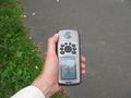
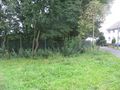
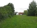
I left home at 14:30, and with the tram 3 and the bus 500 I arrived at Gudensberg at 15:48. Then I walked to the hash. I arrived there at 15:54, I needed five minutes to get the zero meter photo, but at least I found out, that the hash lay right at the fence between the meadow and the stadium. Then I waited until 16:15 for other geohashers to come, but nobody arrived.
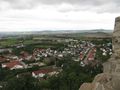
Afterwards I went to the castle and took some photos there, then I walked through the city to the motorway. I started to hitchhike home at 17:49, after a minute a car stopped and I got a lift to Kassel, where I arrived at 18:07.
Photos
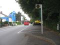
the bus stop in Gudensberg, where I left the bus
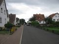
walking to the hash along this street
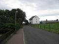
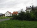
hash is near, but not seen
arrived at hash
view to the north
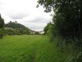
view to the east and to the castle
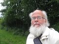
the geohasher
proof of the dance
view to the hash, it is the pole right of the tree
view to the west
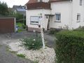
I found a weird geocache
view to the hash from the castle
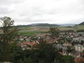
view to Gudensberg from the castle
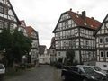
the old marketplace of Gudensberg


Achievements
GeorgDerReisende earned the Public transport geohash achievement
|
GeorgDerReisende earned the Hash collision honorable mention
|
GeorgDerReisende earned the xkcd Decurion achievement
|