Difference between revisions of "2015-08-22 51 0"
imported>Huinesoron (Start) |
imported>FippeBot m (Location) |
||
| (6 intermediate revisions by 2 users not shown) | |||
| Line 1: | Line 1: | ||
| + | [[Image:{{{image|2015-08-22 51 0 GoFlyAnAchievement.jpg}}}|thumb|left]] | ||
| − | |||
| − | |||
| − | |||
| − | |||
| − | |||
| − | |||
| − | |||
| − | |||
| − | |||
{{meetup graticule | {{meetup graticule | ||
| lat=51 | | lat=51 | ||
| lon=0 | | lon=0 | ||
| date=2015-08-22 | | date=2015-08-22 | ||
| + | | graticule_name=London East, UK | ||
| + | | graticule_link=London East, United Kingdom | ||
}} | }} | ||
| − | |||
| − | |||
| − | |||
| − | |||
== Location == | == Location == | ||
| − | + | In a field (of course) north of the river Crouch. Just off the road, though. | |
== Participants == | == Participants == | ||
| − | |||
| − | |||
| − | + | * [[User:Huinesoron|Huinesoron]] ([[User talk:Huinesoron|talk]]) will potentially attend if there's any chance of a meetup. If no-one else is around, though, it's a bit too far. | |
| − | + | * [[User:Benjw|Benjw]] always enjoys meeting other hashers. | |
== Expedition == | == Expedition == | ||
| − | |||
| − | == | + | === [[User:Huinesoron|Huinesoron]]'s Report === |
| − | < | + | |
| + | Following the unexpected appearance of [[User:Benjw|Benjw]] on my talk page, I made firm plans to hit this Saturday Meetup. That meant some negotiations with my wife - she decided not to come with me, so I had to make this as quick as possible. | ||
| + | |||
| + | I set off just after 3, following a set of printed directions from Google Maps. Which ''of course'' meant I got lost in a tangle of turnings, ended up doing a U-turn on a major road, and then had to come back up it when it turned out I'd been going the right way after all. Of ''course'' it did. | ||
| + | |||
| + | I counted the 1.7 miles from the last turning, and was pleased to find the hash-field exactly where it should be. Unfortunately the driveway opposite it turned out to be surrounded by giant hills, so I had to keep going to find a parking spot. I ended up a little way up the road, pulled up in a churchyard lay-by. | ||
| + | |||
| + | The hash was a ways back down the road, so I hopped out and started walking. Then a car passed me, moving slowly, and with what appeared to be a wildly-grinning lunatic at the wheel. "Ah," I thought. "That looks like a geohasher." | ||
| + | |||
| + | And it was! Benjw parked right behind my car, and I ambled back up the side of the road to meet him. ''Then'' I noticed that it might be possible to cut through the churchyard, rather than walking directly into 60mph traffic. I'm smart, me. ^_^ | ||
| + | |||
| + | It was actually a pleasant walk to the hash. There was a gate from the churchyard into a field of grass and stubble, which we could amble across in the direction of the opposite hedge. Then... okay, then I admit we had to scramble through brambles to get any further. But ''apart from that'' it was a pleasant walk. | ||
| + | |||
| + | <gallery perrow="5"> | ||
| + | Image:2015-08-22 51 0 HashgraveHashcar.jpg | 200m is a bit far for a [[Coffin Potato Achievement]], isn't it? | ||
| + | Image:2015-08-22 51 0 GateThroughAHaze.jpg | This gate would have saved my wife a lot of worrying, if I'd told her we found it. | ||
| + | Image:2015-08-22 51 0 ICanGetThrough.jpg | This looks easy enou-OW OW RAPTORS. | ||
| + | </gallery> | ||
| + | |||
| + | Beyond the hedge was a field of... uh, ''something''. It wasn't a grain, or oilseed, or hemp, or grass, or any other crop I recognised. It had lovely little purple flowers that reminded me of orchids, only much tinier. Much conversation passed in trying to work out what it was. | ||
| + | |||
| + | <gallery perrow="5"> | ||
| + | Image:2015-08-22 51 0 MysteryAlfalfa.jpg | A mysterious growth. | ||
| + | </gallery> | ||
| + | |||
| + | I searched for it when I got home. Apparently it was alfalfa. So I learnt something today! | ||
| + | |||
| + | Benjw had brought a mysterious device with him: it was like a map, except that it magically updated to tell you exactly where you were! I dunno, guys, I think this might revolutionise the whole concept of geohashing. ^_^ Anyway, the presence of a GPS made it much easier to find the hashpoint - I usually have to pace the distances out in fields like this. | ||
| + | |||
| + | I'd noticed before leaving home that there was a fair amount of wind, even if it was a bit fitful. And I seem to recall there's an achievement that would be perfect for that... and I just happened to have a micro-kite sitting around at home... (let's not go into the fact that I actually lost mine and had to abscond with my sibling's in order to 'just happen' to have it on hand). So it was kite-time! | ||
| + | |||
| + | <gallery perrow="5"> | ||
| + | Image:2015-08-22 51 0 StupidTMGrin.jpg | The most precise hashpoint I've been to in a while. | ||
| + | Image:2015-08-22 51 0 HashBen.jpg | "There's always a bigger grin." | ||
| + | Image:2015-08-22 51 0 GoFlyAnAchievement.jpg | Fly, my pretty! Fly! | ||
| + | </gallery> | ||
| + | |||
| + | And then... well, it's geohashing, you know what happened then: we wandered back to our cars and left. On the way, I snapped a photo of a nearby wind turbine (I have my reasons), and we poked around the churchyard a bit. I keep saying church''yard'' because the actual church... doesn't exist any more. Or rather, it does - as a private house, which seems to have been completely re-roofed. No idea what that's about. | ||
| + | |||
| + | The most unusual grave was a 1919 military headstone. I've never seen one of those outside a military cemetary; precisely what a guy from a Yorkshire regiment is doing buried in a parish churchyard in Essex is entirely beyond me. | ||
| − | |||
| − | |||
| − | |||
| − | |||
<gallery perrow="5"> | <gallery perrow="5"> | ||
| + | Image:2015-08-22 51 0 GreenPower.jpg | There is a reason for this photo. Honest. | ||
| + | Image:2015-08-22 51 0 MilitaryVisitor.jpg | Perhaps he's on holiday? | ||
</gallery> | </gallery> | ||
| − | == | + | And that's all there was to it. I managed not to get lost on the way home, and arrived about two hours after I'd left. A successful trip! |
| − | + | ||
| − | + | === [[User:Benjw|Benjw]]'s report === | |
| + | |||
| + | I'm not sure there's anything I can really add to the magnificently-written report above. I don't even object to being likened to a wildly-grinning lunatic. | ||
| + | |||
| + | This hashpoint was a bit further than I'd normally go to, and I had been thinking about going to the one in [[Cambridge, United Kingdom|my own graticule]], but it's always good to take the opportunity of actually meeting someone when I can. In the end I decided to go to the Cambridge hashpoint as well; it made for rather a long day, but hey. | ||
| + | |||
| + | I didn't have to negotiate permission from MrsBenjw as she was visiting family for the weekend, so I spent the morning at work, then drove down to Essex via the Hatfield Forest nature reserve. I, too, had a little trouble getting to the hashpoint -- it seems the local towns aren't too keen on signposting any other destinations, resulting in a small amount of driving round in circles looking for the correct road out of wherever I was. Still, I made it pretty much bang on time, slowing down as I approached the field containing the hashpoint, and looking for somewhere I could park. Before finding that, though, I came across someone looking like he might be a geohasher picking his way along the road verge. | ||
| − | + | After our entertaining geohash, I decided that since I'd come this far I might as well look for some of the local geocaches, so I spent a pleasant couple of hours engaged in that, before deciding that if I was going to head to another geohash in the next graticule then I'd better get on with it. I finally left at about 6:30pm. A most excellent day out; thank you Huinesoron. | |
| − | |||
| − | |||
| − | + | == Photos == | |
| − | |||
| − | |||
| − | |||
| − | + | === Huinesoron's Photos === | |
| − | < | + | <gallery perrow="5"> |
| − | [[ | + | Image:2015-08-22 51 0 HashgraveHashcar.jpg | 200m is a bit far for a [[Coffin Potato Achievement]], isn't it? |
| − | -- | + | Image:2015-08-22 51 0 GateThroughAHaze.jpg | This gate would have saved my wife a lot of worrying, if I'd told her we found it. |
| − | + | Image:2015-08-22 51 0 ICanGetThrough.jpg | This looks easy enou-OW OW RAPTORS. | |
| − | + | Image:2015-08-22 51 0 MysteryAlfalfa.jpg | A mysterious growth. | |
| − | + | Image:2015-08-22 51 0 StupidTMGrin.jpg | The most precise hashpoint I've been to in a while. | |
| − | -- | + | Image:2015-08-22 51 0 HashBen.jpg | "There's always a bigger grin." |
| − | + | Image:2015-08-22 51 0 GoFlyAnAchievement.jpg | Fly, my pretty! Fly! | |
| − | + | Image:2015-08-22 51 0 GreenPower.jpg | There is a reason for this photo. Honest. | |
| − | + | Image:2015-08-22 51 0 MilitaryVisitor.jpg | Perhaps he's on holiday? | |
| + | </gallery> | ||
| − | -- | + | == Achievements == |
| − | [[ | + | {{#vardefine:ribbonwidth|800px}} |
| − | -- | + | {{Fly a kite achievement |
| − | + | | latitude = 51 | |
| − | [[ | + | | longitude = 0 |
| − | + | | date = 2015-08-22 | |
| − | + | | name = [[User:Huinesoron|Huinesoron]] ([[User talk:Huinesoron|talk]]) | |
| − | [[ | + | | image = 2015-08-22 51 0 GoFlyAnAchievement.jpg |
| + | }} | ||
| + | {{Meet-up | ||
| + | | latitude = 51 | ||
| + | | longitude = 0 | ||
| + | | date = 2015-08-22 | ||
| + | | name = [[User:Huinesoron|Huinesoron]] ([[User talk:Huinesoron|talk]]) | ||
| + | | other = [[User:Benjw|Benjw]] | ||
| + | }} | ||
| − | |||
| − | |||
| − | |||
| − | |||
| − | |||
| − | + | [[Category:Expeditions]] | |
| + | [[Category:Expeditions with photos]] | ||
| + | [[Category:Coordinates reached]] | ||
| + | {{location|GB|ENG|ESS}} | ||
Latest revision as of 04:52, 15 August 2019
| Sat 22 Aug 2015 in London East, UK: 51.6552329, 0.7231957 geohashing.info google osm bing/os kml crox |
Contents
Location
In a field (of course) north of the river Crouch. Just off the road, though.
Participants
- Huinesoron (talk) will potentially attend if there's any chance of a meetup. If no-one else is around, though, it's a bit too far.
- Benjw always enjoys meeting other hashers.
Expedition
Huinesoron's Report
Following the unexpected appearance of Benjw on my talk page, I made firm plans to hit this Saturday Meetup. That meant some negotiations with my wife - she decided not to come with me, so I had to make this as quick as possible.
I set off just after 3, following a set of printed directions from Google Maps. Which of course meant I got lost in a tangle of turnings, ended up doing a U-turn on a major road, and then had to come back up it when it turned out I'd been going the right way after all. Of course it did.
I counted the 1.7 miles from the last turning, and was pleased to find the hash-field exactly where it should be. Unfortunately the driveway opposite it turned out to be surrounded by giant hills, so I had to keep going to find a parking spot. I ended up a little way up the road, pulled up in a churchyard lay-by.
The hash was a ways back down the road, so I hopped out and started walking. Then a car passed me, moving slowly, and with what appeared to be a wildly-grinning lunatic at the wheel. "Ah," I thought. "That looks like a geohasher."
And it was! Benjw parked right behind my car, and I ambled back up the side of the road to meet him. Then I noticed that it might be possible to cut through the churchyard, rather than walking directly into 60mph traffic. I'm smart, me. ^_^
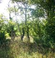
It was actually a pleasant walk to the hash. There was a gate from the churchyard into a field of grass and stubble, which we could amble across in the direction of the opposite hedge. Then... okay, then I admit we had to scramble through brambles to get any further. But apart from that it was a pleasant walk.
200m is a bit far for a Coffin Potato Achievement, isn't it?
Beyond the hedge was a field of... uh, something. It wasn't a grain, or oilseed, or hemp, or grass, or any other crop I recognised. It had lovely little purple flowers that reminded me of orchids, only much tinier. Much conversation passed in trying to work out what it was.
I searched for it when I got home. Apparently it was alfalfa. So I learnt something today!
Benjw had brought a mysterious device with him: it was like a map, except that it magically updated to tell you exactly where you were! I dunno, guys, I think this might revolutionise the whole concept of geohashing. ^_^ Anyway, the presence of a GPS made it much easier to find the hashpoint - I usually have to pace the distances out in fields like this.
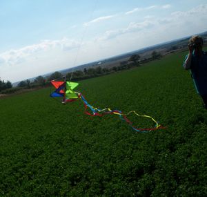
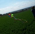
I'd noticed before leaving home that there was a fair amount of wind, even if it was a bit fitful. And I seem to recall there's an achievement that would be perfect for that... and I just happened to have a micro-kite sitting around at home... (let's not go into the fact that I actually lost mine and had to abscond with my sibling's in order to 'just happen' to have it on hand). So it was kite-time!
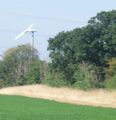
And then... well, it's geohashing, you know what happened then: we wandered back to our cars and left. On the way, I snapped a photo of a nearby wind turbine (I have my reasons), and we poked around the churchyard a bit. I keep saying churchyard because the actual church... doesn't exist any more. Or rather, it does - as a private house, which seems to have been completely re-roofed. No idea what that's about.
The most unusual grave was a 1919 military headstone. I've never seen one of those outside a military cemetary; precisely what a guy from a Yorkshire regiment is doing buried in a parish churchyard in Essex is entirely beyond me.
And that's all there was to it. I managed not to get lost on the way home, and arrived about two hours after I'd left. A successful trip!
Benjw's report
I'm not sure there's anything I can really add to the magnificently-written report above. I don't even object to being likened to a wildly-grinning lunatic.
This hashpoint was a bit further than I'd normally go to, and I had been thinking about going to the one in my own graticule, but it's always good to take the opportunity of actually meeting someone when I can. In the end I decided to go to the Cambridge hashpoint as well; it made for rather a long day, but hey.
I didn't have to negotiate permission from MrsBenjw as she was visiting family for the weekend, so I spent the morning at work, then drove down to Essex via the Hatfield Forest nature reserve. I, too, had a little trouble getting to the hashpoint -- it seems the local towns aren't too keen on signposting any other destinations, resulting in a small amount of driving round in circles looking for the correct road out of wherever I was. Still, I made it pretty much bang on time, slowing down as I approached the field containing the hashpoint, and looking for somewhere I could park. Before finding that, though, I came across someone looking like he might be a geohasher picking his way along the road verge.
After our entertaining geohash, I decided that since I'd come this far I might as well look for some of the local geocaches, so I spent a pleasant couple of hours engaged in that, before deciding that if I was going to head to another geohash in the next graticule then I'd better get on with it. I finally left at about 6:30pm. A most excellent day out; thank you Huinesoron.
Photos
Huinesoron's Photos
200m is a bit far for a Coffin Potato Achievement, isn't it?
Achievements
Huinesoron (talk) earned the Fly a kite achievement
|
Huinesoron (talk) earned the Meet-up achievement
|


