Difference between revisions of "2015-10-13 52 1"
From Geohashing
imported>Sourcerer (→Planning) |
imported>FippeBot m (Location) |
||
| (7 intermediate revisions by one other user not shown) | |||
| Line 3: | Line 3: | ||
| lon=1 | | lon=1 | ||
| date=2015-10-13 | | date=2015-10-13 | ||
| + | | graticule_name=Norwich, UK | ||
| + | | graticule_link=Norwich, United Kingdom | ||
}} | }} | ||
__NOTOC__ | __NOTOC__ | ||
| Line 8: | Line 10: | ||
== Location == | == Location == | ||
| − | Close to a field entrance between Spixworth and Frettenham, Norfolk, UK. | + | Close to a field entrance between Spixworth and Frettenham, Norfolk, UK. [http://w3w.co/blunt.crest.marked blunt.crest.marked] |
== Participants == | == Participants == | ||
| Line 16: | Line 18: | ||
== Plans == | == Plans == | ||
| − | Expedition one of two spanning midnight - [[2015-10-13 52 1]] - [[2015-10-14 52 | + | Expedition one of two spanning midnight - [[2015-10-13 52 1]] - [[2015-10-14 52 0]] - ETA 22:10. |
== Expedition == | == Expedition == | ||
| + | *Arrived. -- [[User:Sourcerer|Sourcerer]] ([[User talk:Sourcerer|talk]]) [http://www.openstreetmap.org/?lat=52.69629836&lon=1.31496370&zoom=16&layers=B000FTF @52.6963,1.3150] 21:51, 13 October 2015 (GMT+01:00) | ||
| + | There was a place to park in the quarry access road entrance. The walk to the hashpoint, across the main road, followed tractor tracks through new oil seed rape seedlings. There was a slight drizzle. | ||
== Photos == | == Photos == | ||
<gallery> | <gallery> | ||
| + | Image:2015-10-13_52_1_Sourcerer_1444769443831.jpg | Proof. [http://www.openstreetmap.org/?lat=52.69629836&lon=1.31496370&zoom=16&layers=B000FTF @52.6963,1.3150] | ||
| + | Image:2015-10-13_52_1_Sourcerer.jpg | Track in Google Earth | ||
</gallery> | </gallery> | ||
| Line 32: | Line 38: | ||
| prev = 2015-10-12 52 1 | | prev = 2015-10-12 52 1 | ||
| curr = 2015-10-13 52 1 | | curr = 2015-10-13 52 1 | ||
| − | | next = 2015-10-14 52 | + | | next = 2015-10-14 52 0 |
| date = 2015-10-13 | | date = 2015-10-13 | ||
}} | }} | ||
| − | |||
| − | |||
[[Category:Expeditions]] | [[Category:Expeditions]] | ||
[[Category:Expeditions with photos]] | [[Category:Expeditions with photos]] | ||
[[Category:Coordinates reached]] | [[Category:Coordinates reached]] | ||
| − | + | {{location|GB|ENG|NFK}} | |
Latest revision as of 05:26, 15 August 2019
| Tue 13 Oct 2015 in Norwich, UK: 52.6963171, 1.3149675 geohashing.info google osm bing/os kml crox |
Location
Close to a field entrance between Spixworth and Frettenham, Norfolk, UK. blunt.crest.marked
Participants
Plans
Expedition one of two spanning midnight - 2015-10-13 52 1 - 2015-10-14 52 0 - ETA 22:10.
Expedition
- Arrived. -- Sourcerer (talk) @52.6963,1.3150 21:51, 13 October 2015 (GMT+01:00)
There was a place to park in the quarry access road entrance. The walk to the hashpoint, across the main road, followed tractor tracks through new oil seed rape seedlings. There was a slight drizzle.
Photos
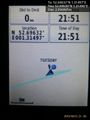
Proof. @52.6963,1.3150
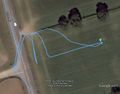
Track in Google Earth


Achievements
Expeditions and Plans
| 2015-10-13 | ||
|---|---|---|
| Southampton, United Kingdom | Zamzara | fell just on the outside of the (slightly prison-like) fence around Carisbr... |
| Erfurt, Germany | FriedrichFröbel | It is situated in a part of the Thuringian town Rudolstadt on the way to Ze... |
| Norwich, United Kingdom | Sourcerer | Close to a field entrance between Spixworth and Frettenham, Norfolk, UK. blunt.crest.marked... |
Sourcerer's Expedition Links
2015-10-12 52 1 - 2015-10-13 52 1 - 2015-10-14 52 0 - KML file download of Sourcerer's expeditions for use with Google Earth.