Difference between revisions of "2016-07-03 52 1"
imported>Sourcerer (→Planning) |
imported>FippeBot m (Location) |
||
| (3 intermediate revisions by one other user not shown) | |||
| Line 17: | Line 17: | ||
== Plans == | == Plans == | ||
| − | One of | + | One of three spanning midnight - [[2016-07-03 52 1]] - [[2010-11-21 51 1|2010-11-21 51 1 Retro]] - [[2016-07-04 51 1]] - ETA 23:25. |
This looks as though it's in a private back garden but the Google map image accuracy could put the point on public land. | This looks as though it's in a private back garden but the Google map image accuracy could put the point on public land. | ||
| Line 23: | Line 23: | ||
== Expedition == | == Expedition == | ||
| + | *Arrived. -- [[User:Sourcerer|Sourcerer]] ([[User talk:Sourcerer|talk]]) [http://www.openstreetmap.org/?lat=52.14914918&lon=1.05727315&zoom=16&layers=B000FTF @52.1491,1.0573] 23:13, 3 July 2016 (GMT+01:00) | ||
| + | The destination was in a residential street, with some uncertainty whether it was on the street or garden side of the fence and gate. I managed to shuffle three metres from the zero point. Close enough. My arrival upload was from the street side, a bit further from the house, outside the glare of the security light that flashed on. | ||
== Photos == | == Photos == | ||
<gallery caption="Photo Gallery" widths="200px" heights="200px" perrow="3"> | <gallery caption="Photo Gallery" widths="200px" heights="200px" perrow="3"> | ||
| + | Image:2016-07-03 52 1 Sourcerer Track.jpg | Google Earth Track | ||
| + | Image:2016-07-03 52 1 Sourcerer.jpg | Proof | ||
</gallery> | </gallery> | ||
| Line 40: | Line 44: | ||
}} | }} | ||
| − | |||
| − | |||
[[Category:Expeditions]] | [[Category:Expeditions]] | ||
[[Category:Expeditions with photos]] | [[Category:Expeditions with photos]] | ||
[[Category:Coordinates reached]] | [[Category:Coordinates reached]] | ||
| − | + | {{location|GB|ENG|SFK}} | |
Latest revision as of 11:45, 16 August 2019
| Sun 3 Jul 2016 in Norwich, UK: 52.1492068, 1.0573026 geohashing.info google osm bing/os kml crox |
Location
A house and garden in Needham Market, Suffolk, UK.
Participants
Plans
One of three spanning midnight - 2016-07-03 52 1 - 2010-11-21 51 1 Retro - 2016-07-04 51 1 - ETA 23:25.
This looks as though it's in a private back garden but the Google map image accuracy could put the point on public land.
Expedition
- Arrived. -- Sourcerer (talk) @52.1491,1.0573 23:13, 3 July 2016 (GMT+01:00)
The destination was in a residential street, with some uncertainty whether it was on the street or garden side of the fence and gate. I managed to shuffle three metres from the zero point. Close enough. My arrival upload was from the street side, a bit further from the house, outside the glare of the security light that flashed on.
Photos
- Photo Gallery
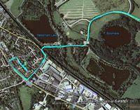
Google Earth Track
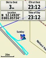
Proof


Achievements
Expeditions and Plans
| 2016-07-03 | ||
|---|---|---|
| Canberra, Australia | 1PE | In a farm field beside the Wattle Park church, beside the Barton Highway (a... |
| Norwich, United Kingdom | Sourcerer | A house and garden in Needham Market, Suffolk, UK. |
| Braunschweig, Germany | GeorgDerReisende | The hash lay on an edge of a field north of Wendhausen. |
| Klin, Russia | vb | Not far away from Volokolamsk-Klin road, almost not in the woods. |
Sourcerer's Expedition Links
2016-06-28 52 1 - 2016-07-03 52 1 - 2016-07-04 51 1 - KML file download of Sourcerer's expeditions for use with Google Earth.