2016-06-28 52 1
| Tue 28 Jun 2016 in Norwich: 52.7241148, 1.2321891 |
Location
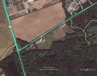
On Short Thorn Road, Horsford, Norfolk, UK.
Participants
Plans
Three of three spanning midnight - 2012-04-27 52 1 Retro - 2016-06-27 52 1 - 2016-06-28 52 1 - ETA 00:00.
Expedition
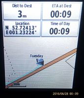
This was a road hashpoint. The GPSr image shows 3 metres but it dropped to 1 and climbed back to 3 before I managed the evidence photo. There was no need to get out of the car. My time planning was spot on. Real life took a bit longer than expected. It took longer than normal to walk the dog before setting out and I added 4.5 km to my journey by missing a turning. It's fun to get the proof photo at 00:00 local time but no luck today. The 3G signal was too weak to upload any live data. I did get a partial map download before it failed.
Photos
- Photo Gallery
Achievements
Sourcerer earned the Midnight Geohash achievement
|
Expeditions and Plans
| 2016-06-28 | ||
|---|---|---|
| Manhattan, Kansas | thunk | Northeast of Clay Center on the way to the nearby globalhash |
| Concord, New Hampshire | Mcbaneg, Katja, Rebekah, Sylvia | Wooded hillside in Alexandria, NH |
| Alert Bay, British Columbia | dunstergirl | On the ocean somewhere south of Donegal Head on Malcolm Island, a bit west ... |
| Norwich, United Kingdom | Sourcerer | On Short Thorn Road, Horsford, Norfolk, UK. |
| Gävle, Sweden | FelixTheCat | In a forest in Gävle, Sweden. |
| Globalhash | thunk | Near Crab Orchard, Johnson County, Nebraska, USA, in the middle of a (legum... |
Sourcerer's Expedition Links
2016-06-27 52 1 - 2016-06-28 52 1 - 2016-07-03 52 1 - KML file download of Sourcerer's expeditions for use with Google Earth.

