Difference between revisions of "2016-07-18 52 1"
From Geohashing
imported>Sourcerer (→Planning) |
imported>FippeBot m (Location) |
||
| (6 intermediate revisions by one other user not shown) | |||
| Line 21: | Line 21: | ||
== Expedition == | == Expedition == | ||
| + | *Waiting for midnight. -- [[User:Sourcerer|Sourcerer]] ([[User talk:Sourcerer|talk]]) [http://www.openstreetmap.org/?lat=52.35433817&lon=1.13334596&zoom=16&layers=B000FTF @52.3543,1.1333] 23:52, 17 July 2016 (GMT+01:00) | ||
| + | *Yea midnight. -- [[User:Sourcerer|Sourcerer]] ([[User talk:Sourcerer|talk]]) [http://www.openstreetmap.org/?lat=52.35434353&lon=1.13337278&zoom=16&layers=B000FTF @52.3543,1.1334] 00:00, 18 July 2016 (GMT+01:00) | ||
| − | == Photos == | + | A dead end road led towards a church. Well before the end of the road there was the perfect field entrance parking place. There were well defined tractor tracks into the barley crop. Arriving nine minutes early gave the ideal opportunity to delete a bunch of historical evidence photos. The sky was clear. The moon was approaching full. It was a mild 16 C. At midnight I uploaded the arrival message. 30 minutes later I was back home. |
| + | |||
| + | == Photos == | ||
<gallery caption="Photo Gallery" widths="200px" heights="200px" perrow="3"> | <gallery caption="Photo Gallery" widths="200px" heights="200px" perrow="3"> | ||
| + | Image:2016-07-18_52_1_Sourcerer_1468795880343.jpg | Proof. [http://www.openstreetmap.org/?lat=52.35433817&lon=1.13334596&zoom=16&layers=B000FTF @52.3543,1.1333] | ||
| + | Image:2016-07-18_52_1_Sourcerer.jpg | Google Earth Track | ||
</gallery> | </gallery> | ||
| Line 41: | Line 47: | ||
| prev = 2016-07-17 52 1 | | prev = 2016-07-17 52 1 | ||
| curr = 2016-07-18 52 1 | | curr = 2016-07-18 52 1 | ||
| − | | next = 2016-07- | + | | next = 2016-07-20 52 1 |
| date = 2016-07-18 | | date = 2016-07-18 | ||
}} | }} | ||
| − | |||
| − | |||
[[Category:Expeditions]] | [[Category:Expeditions]] | ||
[[Category:Expeditions with photos]] | [[Category:Expeditions with photos]] | ||
[[Category:Coordinates reached]] | [[Category:Coordinates reached]] | ||
| − | + | {{location|GB|ENG|SFK}} | |
Latest revision as of 01:02, 16 August 2019
| Mon 18 Jul 2016 in Norwich, UK: 52.3543422, 1.1333489 geohashing.info google osm bing/os kml crox |
Location
A field south of Stuston, Suffolk, UK.
Participants
Plans
Two of two spanning midnight - 2016-07-17 52 1 - 2016-07-18 52 1 - ETA 00:00.
Expedition
- Waiting for midnight. -- Sourcerer (talk) @52.3543,1.1333 23:52, 17 July 2016 (GMT+01:00)
- Yea midnight. -- Sourcerer (talk) @52.3543,1.1334 00:00, 18 July 2016 (GMT+01:00)
A dead end road led towards a church. Well before the end of the road there was the perfect field entrance parking place. There were well defined tractor tracks into the barley crop. Arriving nine minutes early gave the ideal opportunity to delete a bunch of historical evidence photos. The sky was clear. The moon was approaching full. It was a mild 16 C. At midnight I uploaded the arrival message. 30 minutes later I was back home.
Photos
- Photo Gallery
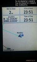
Proof. @52.3543,1.1333
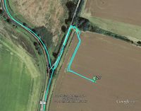
Google Earth Track


Achievements
Sourcerer earned the Midnight Geohash achievement
|
Expeditions and Plans
| 2016-07-18 | ||
|---|---|---|
| Canberra, Australia | 1PE | Mugga Lane, within a construction site for roadworks, near the hard rock mi... |
| Kassel, Germany | GeorgDerReisende | In front of a house in Wolfhagen-Viesebeck. |
| Norwich, United Kingdom | Sourcerer | A field south of Stuston, Suffolk, UK. |
Sourcerer's Expedition Links
2016-07-17 52 1 - 2016-07-18 52 1 - 2016-07-20 52 1 - KML file download of Sourcerer's expeditions for use with Google Earth.