Difference between revisions of "2016-09-14 49 7"
imported>DODO (Created page with "{{subst:Expedition |lat = 49 |lon = 7 |date = 2016-09-14 }}") |
imported>FippeBot m (Location) |
||
| (9 intermediate revisions by one other user not shown) | |||
| Line 20: | Line 20: | ||
== Location == | == Location == | ||
<!-- where you've surveyed the hash to be --> | <!-- where you've surveyed the hash to be --> | ||
| + | A harvested field near Laufersweiler (Hunsrück). | ||
== Participants == | == Participants == | ||
<!-- who attended: If you link to your wiki user name in this section, your expedition will be picked up by the various statistics generated for geohashing. You may use three tildes ~ as a shortcut to automatically insert the user signature of the account you are editing with. | <!-- who attended: If you link to your wiki user name in this section, your expedition will be picked up by the various statistics generated for geohashing. You may use three tildes ~ as a shortcut to automatically insert the user signature of the account you are editing with. | ||
--> | --> | ||
| + | [[User:DODO|DODO]] | ||
== Plans == | == Plans == | ||
<!-- what were the original plans --> | <!-- what were the original plans --> | ||
| + | It was possible to reach todays hash in the Luxembourg-graticule from Prüm ([[2016-09-13_50_6|where I ended up yesterday]]) and continue the ride to Trier, where I could certainly find a train that'd bring me home. But I saw the possibility for my first multi-hash achievement, when I go for this one (and the Mannheim-one). | ||
== Expedition == | == Expedition == | ||
| − | + | First of all I had to get to a station to get near the hash. The next station to Prüm was in Gerolstein, 24 kilometers away, as komoot told me. The train to Trier goes every two hours. I wanted to catch the one at 10:03, so I started unusual early at 8:30 (I even wanted to start earlier, but that didn't work). Just when I left Prüm I had to conquer 150 m of height. So I was pretty late, when I reached the main road to Gerolstein again. I decided, not to follow the planned way but to continue the ride on the main road to catch my train. That way the route was 5 kilometers shorter. So everything went as planned. I got the train at 10:03, changed trains in Trier and rode to Bullay (at the Mosel). From here I had planned to ride over the Hunsrück (where the hash was) to the rivulet Nahe, from where I could catch a train to Mainz, close to the hash in the Mannheim graticule. | |
| + | |||
| + | I reached Bullay in time at 12:09 and started to ride. First I had to cross the Moselle and it took me some time (and more than a kilometer) to find the way onto the bridge. After that, I followed the Moselle for some time. In Zell I left the river. From here I had to climb 350m and so the next 10 kilometers took me more than an hour. After I rode a while over the heights of the Hunsrück I got really hungry. I planned, to eat some ice-cream in the next occasion. Soren seemed be a bigger village, but I didn't find any ice-cream there. So I switched to some fried potatoes and curry sausage. Invigorated I went about the last part to the hash. Two kilometers after Sohren I had to leave the road and take some country lanes, then I reached the hash field. 100m into the harvested field, and another success was reached. It was an important one for me, because it was my 128th, what brings me another shiny ribbon :-) | ||
| + | |||
| + | I still had 20 kilometers to go, so I hurried to get on. Soon I reached the next road but I had to leave it again and roll down a small grassy path to the next one. Then I drove down to Rhauonen in the valley of the Idarbach, but I had to leave the valley again to go to Bundenbach.I thought that I could just roll down to the Nahe from here, but komoot sent me on a forrest path, that was much to small and uneven to ride and so I had to push my bike for a while. But at least I reached another road and soon I reached the station in Kirn. At 16:21 I got the RB29577 to Mainz. | ||
== Tracklog == | == Tracklog == | ||
| − | + | [https://www.komoot.de/tour/12349854 24 KM by bike] from Prüm to Gerolsteimn and another [https://www.komoot.de/tour/12365166 52 KM] from Bullay to the hash and further to Kirn. I haven't tracked another 185 KM by train. | |
== Photos == | == Photos == | ||
| − | < | + | |
| − | Image: | + | <gallery perrow="4"> |
| − | -- | + | Image: 2016-09-14 49 7-00.jpg|bike |
| − | + | Image: 2016-09-14 49 7-01.jpg|view to the hash | |
| + | Image: 2016-09-14 49 7-12.png|proof | ||
| + | Image: 2016-09-14 49 7-02.jpg|south | ||
| + | Image: 2016-09-14 49 7-03.jpg|west | ||
| + | Image: 2016-09-14 49 7-04.jpg|north | ||
| + | Image: 2016-09-14 49 7-05.jpg|east (with bike) | ||
| + | Image: 2016-09-14 49 7-06.jpg|stupid grin | ||
</gallery> | </gallery> | ||
== Achievements == | == Achievements == | ||
| − | |||
| − | |||
| − | + | {{land geohash | |
| − | + | | latitude = 49 | |
| − | + | | longitude = 7 | |
| + | | date = 2016-09-14 | ||
| + | | name = DODO | ||
| + | }} | ||
| − | + | {{Two to the N achievement | |
| + | | count = 7 | ||
| + | | date = 2016-09-14 | ||
| + | | latitude = 49 | ||
| + | | longitude = 7 | ||
| + | | name = DODO | ||
| + | | reached = true (optional - include if you are counting coordinates reached) | ||
| + | }} | ||
| − | + | Hey, I got there by train, or is that invalidated by biking 76 kilometers? | |
| − | + | {{Public transport geohash | |
| − | + | | latitude = 49 | |
| − | + | | longitude = 7 | |
| + | | date = 2016-09-14 | ||
| + | | name = DODO | ||
| + | }} | ||
| + | |||
| + | {{consecutive geohash | ||
| + | | count = 4 | ||
| + | | latitude = 49 | ||
| + | | longitude = 7 | ||
| + | | date = 2016-09-14 | ||
| + | | name = DODO | ||
| + | }} | ||
| − | + | {{Regional geohashing | |
| + | | name = [[User:DODO|DODO]] | ||
| + | | region = Rhein-Hunsrück-Kreis | ||
| + | | count = 2 | ||
| + | }} | ||
| − | |||
[[Category:Expeditions]] | [[Category:Expeditions]] | ||
| − | |||
| − | |||
| − | |||
| − | |||
| − | |||
| − | |||
| − | |||
[[Category:Coordinates reached]] | [[Category:Coordinates reached]] | ||
| − | + | {{location|DE|RP|GOA}} | |
| − | |||
| − | |||
| − | |||
| − | |||
| − | |||
| − | |||
| − | |||
| − | |||
| − | |||
| − | |||
| − | |||
| − | |||
| − | |||
| − | |||
| − | |||
| − | |||
| − | |||
Latest revision as of 01:27, 16 August 2019
| Wed 14 Sep 2016 in 49,7: 49.9039503, 7.3133083 geohashing.info google osm bing/os kml crox |
Location
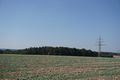
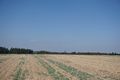
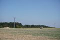
A harvested field near Laufersweiler (Hunsrück).
Participants
Plans
It was possible to reach todays hash in the Luxembourg-graticule from Prüm (where I ended up yesterday) and continue the ride to Trier, where I could certainly find a train that'd bring me home. But I saw the possibility for my first multi-hash achievement, when I go for this one (and the Mannheim-one).
Expedition
First of all I had to get to a station to get near the hash. The next station to Prüm was in Gerolstein, 24 kilometers away, as komoot told me. The train to Trier goes every two hours. I wanted to catch the one at 10:03, so I started unusual early at 8:30 (I even wanted to start earlier, but that didn't work). Just when I left Prüm I had to conquer 150 m of height. So I was pretty late, when I reached the main road to Gerolstein again. I decided, not to follow the planned way but to continue the ride on the main road to catch my train. That way the route was 5 kilometers shorter. So everything went as planned. I got the train at 10:03, changed trains in Trier and rode to Bullay (at the Mosel). From here I had planned to ride over the Hunsrück (where the hash was) to the rivulet Nahe, from where I could catch a train to Mainz, close to the hash in the Mannheim graticule.
I reached Bullay in time at 12:09 and started to ride. First I had to cross the Moselle and it took me some time (and more than a kilometer) to find the way onto the bridge. After that, I followed the Moselle for some time. In Zell I left the river. From here I had to climb 350m and so the next 10 kilometers took me more than an hour. After I rode a while over the heights of the Hunsrück I got really hungry. I planned, to eat some ice-cream in the next occasion. Soren seemed be a bigger village, but I didn't find any ice-cream there. So I switched to some fried potatoes and curry sausage. Invigorated I went about the last part to the hash. Two kilometers after Sohren I had to leave the road and take some country lanes, then I reached the hash field. 100m into the harvested field, and another success was reached. It was an important one for me, because it was my 128th, what brings me another shiny ribbon :-)
I still had 20 kilometers to go, so I hurried to get on. Soon I reached the next road but I had to leave it again and roll down a small grassy path to the next one. Then I drove down to Rhauonen in the valley of the Idarbach, but I had to leave the valley again to go to Bundenbach.I thought that I could just roll down to the Nahe from here, but komoot sent me on a forrest path, that was much to small and uneven to ride and so I had to push my bike for a while. But at least I reached another road and soon I reached the station in Kirn. At 16:21 I got the RB29577 to Mainz.
Tracklog
24 KM by bike from Prüm to Gerolsteimn and another 52 KM from Bullay to the hash and further to Kirn. I haven't tracked another 185 KM by train.
Photos
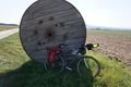
bike
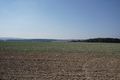
view to the hash
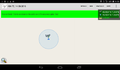
proof
south
west
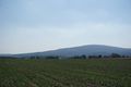
north
east (with bike)

stupid grin


Achievements
DODO earned the Land geohash achievement
|
DODO earned the Two to the N achievement
|
Hey, I got there by train, or is that invalidated by biking 76 kilometers?
DODO earned the Public transport geohash achievement
|
DODO earned the Consecutive geohash achievement
|
DODO earned the Regional geohashing achievement
|